Show All Information
Maps
Part Of
May and Elmer Ellingsen fonds
Description Level
Series
Material Type
textual records
cartographic material
Date Range
[ca.1900]-1974
Scope and Content
Series consists of maps of Hernando and Cortes Islands. Some of the maps contain information on pre-emptions and homesteads.
Show All Information
Maps of Hernando Island
Part Of
May and Elmer Ellingsen fonds
Description Level
File
Material Type
cartographic material
textual records
Date Range
[190?] - 1955
Scope and Content
File contains five maps of Hernando Island: two showing plans of pre-emptions, 1891-1892; two copies of an old hand-drawn map, 1955; and one map of a later proposed development (undated). Some maps have notes on homesteads.
Part Of
May and Elmer Ellingsen fonds
Description Level
File
Fonds Number
2007.001
Series Number
10
File Number
1
Material Type
cartographic material textual records
Date Range
[190?] - 1955
Scope and Content
File contains five maps of Hernando Island: two showing plans of pre-emptions, 1891-1892; two copies of an old hand-drawn map, 1955; and one map of a later proposed development (undated). Some maps have notes on homesteads.
Storage Location
7-64
Storage Range
7-64
Geographic Access
Hernando Island
Show less information
Show All Information
Map of N. Vancouver Island area by the Dept. of Lands and Forests
Part Of
May and Elmer Ellingsen fonds
Description Level
File
Material Type
textual records
cartographic material
Date Range
1948
Scope and Content
File contains
Show All Information
Maps of Cortes Island and Read Island
Part Of
May and Elmer Ellingsen fonds
Description Level
File
Material Type
textual records
Date Range
[1949?]
Scope and Content
File contains blue copies of maps showing property lot lines on Cortes Island and Read Island.
Part Of
May and Elmer Ellingsen fonds
Description Level
File
Fonds Number
2007.001
Series Number
10
File Number
3
Material Type
textual records
Date Range
[1949?]
Scope and Content
File contains blue copies of maps showing property lot lines on Cortes Island and Read Island.
Storage Location
7-66
Storage Range
7-66
Show less information
Show All Information
Maps
Part Of
May and Elmer Ellingsen fonds
Description Level
File
Material Type
cartographic material
textual records
Date Range
1950-1974
Scope and Content
File contains maps of Bute Inlet (1970), Cortes Island/Read Island and surrounding area (ca. 1950), Powell River (1968) and Cortes Island zoning maps (Jan 1974).
Show All Information
Map of Section 6/7 on Hague Lake
Part Of
May and Elmer Ellingsen fonds
Description Level
File
Material Type
textual records
Date Range
1953
Scope and Content
File contains a map of Section 6/7 by Hague Lake.
Show All Information
Map of Cortes Island REFILED?? check
Part Of
May and Elmer Ellingsen fonds
Description Level
File
Material Type
textual records
Date Range
1963
Scope and Content
File contains a photo-copy of a hand-drawn map of Cortes Island.
Show All Information
Maps of Cortes Island & surrounding area
Part Of
May and Elmer Ellingsen fonds
Description Level
File
Accession Number
2019.002
Date Range
1994
Scope and Content
File contains four (4) maps, one with handwritten notations of old homesteads.
Part Of
May and Elmer Ellingsen fonds
Description Level
File
Fonds Number
2007.001
Series Number
10
File Number
8
Accession Number
2019.002
Date Range
1994
Scope and Content
File contains four (4) maps, one with handwritten notations of old homesteads.
Storage Location
Map cabinet
Storage Range
Map cabinet
Show less information
Show All Information
Settlement maps
Part Of
May and Elmer Ellingsen fonds
Description Level
File
Material Type
textual records
cartographic material
Date Range
[191?]
Scope and Content
File contains hand-drawn maps from the early 1900s. There are two copies of the plan of part of SW 1/4 of Section 34; a plan of Gorge Harbour with names of owners written in; and a plan showing part of Read Island.
Part Of
May and Elmer Ellingsen fonds
Description Level
File
Fonds Number
2007.001
Series Number
6
File Number
2
Material Type
textual records cartographic material
Date Range
[191?]
Scope and Content
File contains hand-drawn maps from the early 1900s. There are two copies of the plan of part of SW 1/4 of Section 34; a plan of Gorge Harbour with names of owners written in; and a plan showing part of Read Island.
Storage Location
6-9
Storage Range
6-9
Show less information
Show All Information
Electrical service: Maps and plans for BC Hydro pole installation and subdivisions
Part Of
May and Elmer Ellingsen fonds
Description Level
File
Material Type
textual records
Date Range
1969-1980
Scope and Content
File contains maps and plans for the installation of power poles, subdivisions, and the school property.
Part Of
May and Elmer Ellingsen fonds
Description Level
File
Fonds Number
2007.001
Series Number
8
File Number
46
Material Type
textual records
Date Range
1969-1980
Scope and Content
File contains maps and plans for the installation of power poles, subdivisions, and the school property.
Storage Location
7-46
Storage Range
7-46
Show less information
Show All Information
Electrical service: road construction standards; maps for electrical pole placement
Part Of
May and Elmer Ellingsen fonds
Description Level
File
Material Type
textual records
Date Range
1980-1986
Scope and Content
File contains a guide to road constructions standards, and a map for the placement of electrical poles for B.C. Hydro.
Part Of
May and Elmer Ellingsen fonds
Description Level
File
Fonds Number
2007.001
Series Number
8
File Number
47
Material Type
textual records
Date Range
1980-1986
Scope and Content
File contains a guide to road constructions standards, and a map for the placement of electrical poles for B.C. Hydro.
Storage Location
7-47
Storage Range
7-47
Show less information
Show All Information
Electrical service: BC Hydro maps and contracts
Part Of
May and Elmer Ellingsen fonds
Description Level
File
Material Type
textual records
Date Range
1984-1985
Scope and Content
File contains BC Hydro maps and contracts with Elmer Ellingsen.
Show All Information
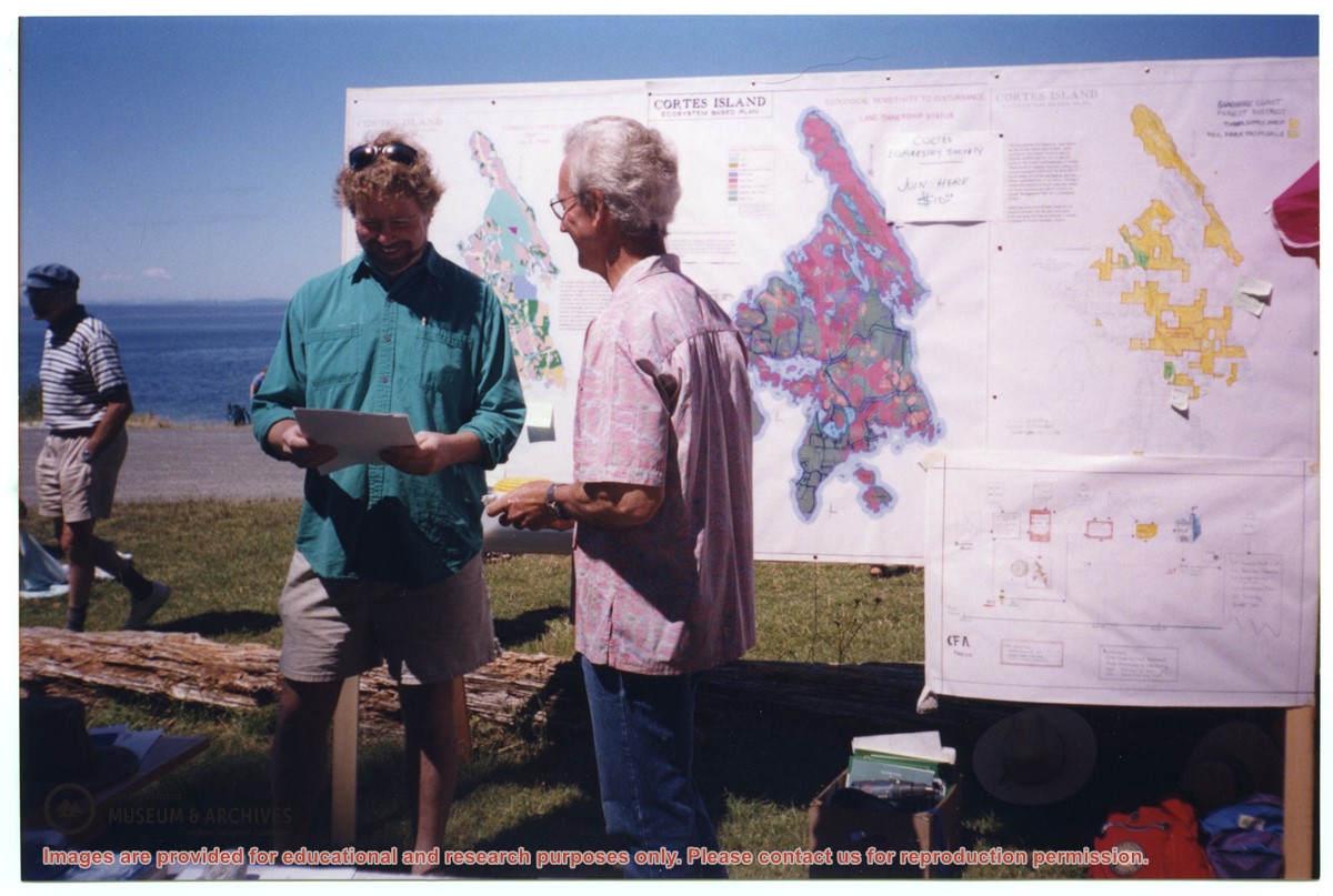
David Shipway and Bruce Ellingsen in front of CES map display at Smelt Bay
Show All Information
David Shipway (L) and Bruce Ellingen in front of CES map display, Smelt Bay