Show All Information
"1:10,000 Composite Mapping for Planning Department of RDCS"
Part Of
Regional Director of Area I (Cortes Island) fonds
Description Level
File
Material Type
textual records
cartographic material
Accession Number
2004.004
Date Range
[198?]
Scope and Content
File contains one book of composite maps of Cortes Island properties in a cerlox binding.
Show All Information
"1:10,000 Composite Mapping for Planning Department of RDCS, June 1987"
Part Of
Regional Director of Area I (Cortes Island) fonds
Description Level
File
Material Type
textual records
cartographic material
Accession Number
2004.004
Date Range
1987
Scope and Content
File contains one book of composite maps of Cortes Island properties in a cerlox binding.
Show All Information
"1:10,000 Composite Mapping for Planning Department of RDCS, September 1990"
Part Of
Regional Director of Area I (Cortes Island) fonds
Description Level
File
Material Type
textual records
cartographic material
Accession Number
2004.004
Date Range
1990
Scope and Content
File contains one book of composite maps of Cortes Island properties in a cerlox binding, with annotations.
Show All Information
Ancient map of Canada
Part Of
Gilean Douglas fonds
Description Level
File
Material Type
cartographic material
Date Range
[197?; orig. 1550]
Scope and Content
A reproduction of a map made by Pierre Desceliers, a cartographer-artist working near Dieppe, after Jacques Cartier's explorations.
Part Of
Gilean Douglas fonds
Description Level
File
Fonds Number
1999.001
Series Number
16
File Number
12
Material Type
cartographic material
Date Range
[197?; orig. 1550]
Physical Description
1 map : 21.75 x 17.25 inches
Scope and Content
A reproduction of a map made by Pierre Desceliers, a cartographer-artist working near Dieppe, after Jacques Cartier's explorations.
Storage Location
Map box
Storage Range
Map box
Name Access
Douglas, Gilean
Show less information
Show All Information
Annotated Cortes Island map
Part Of
Gilean Douglas fonds
Description Level
File
Material Type
cartographic material
Date Range
1969
Scope and Content
The base map is a zoning map produced by the Regional District of Comox-
Strathcona for the Cortes Island Land Use Project (Aug 1969). Edwards used
coloured pencil to show land and foreshore zones, and transferred information
about early preemptions and old roads and trails from an earlier map (see
Donald Palmer fonds, 2020.002.011, map of Cortes Island, Sayward District, ca.
1915).
Part Of
Gilean Douglas fonds
Description Level
File
Fonds Number
1999.001
Series Number
16
File Number
8
Material Type
cartographic material
Date Range
1969
Physical Description
42 x 67 inches (107 x 170 cm)
Scope and Content
The base map is a zoning map produced by the Regional District of Comox-
Strathcona for the Cortes Island Land Use Project (Aug 1969). Edwards used
coloured pencil to show land and foreshore zones, and transferred information
about early preemptions and old roads and trails from an earlier map (see
Donald Palmer fonds, 2020.002.011, map of Cortes Island, Sayward District, ca.
1915).
Storage Location
Map box
Storage Range
Map box
Name Access
Douglas, Gilean
Show less information
Show All Information
Booklet of Cortes Island maps showing house numbers
Part Of
Doreen Thompson fonds
Description Level
File
Material Type
cartographic material
Accession Number
2006.001
Date Range
2001
Show All Information
British Columbia Department of Lands map of Southwestern Districts of BC
Part Of
Gilean Douglas fonds
Description Level
File
Material Type
cartographic material
Date Range
1925
Scope and Content
Coloured map of southwestern BC showing municipalities, geographical features, land and sea routes, natural resources, etc. The back of the map is fully printed with information about BC and suggested travel itineraries.
Map needs preservation: edges are frayed and there are several tears.
Part Of
Gilean Douglas fonds
Description Level
File
Fonds Number
1999.001
Series Number
16
File Number
7
Material Type
cartographic material
Date Range
1925
Physical Description
38 x 36.25 in (31.5 x 80 cm)
Scope and Content
Coloured map of southwestern BC showing municipalities, geographical features, land and sea routes, natural resources, etc. The back of the map is fully printed with information about BC and suggested travel itineraries.
Map needs preservation: edges are frayed and there are several tears.
Storage Location
Map box
Storage Range
Map box
Name Access
Douglas, Gilean
Show less information
Show All Information
Cortes Island Bylaw No. 2454, to amend Schedule A-1 "The Plan Map" to reflect the Official Community Plan
Part Of
Regional Director of Area I (Cortes Island) fonds
Description Level
File
Material Type
textual records
cartographic material
Accession Number
2004.004
Date Range
1995-2002
Scope and Content
File contains a copy of the bylaw and map of 1995, a summary of the changes (meant to reconcile 25 year gap between the previous zoning bylaws and the current OCP), and a completion and adoption strategy.
Show All Information
Cortes Island map
Part Of
Doreen Thompson fonds
Description Level
File
Material Type
cartographic material
Accession Number
2006.001
Date Range
[196?]
Scope and Content
File contains a map of Cortes Island showing quarter-sections with preemption names.
Show All Information
Cortes Island - showing places of interest to our visitors by George Griffin, hand drawn map.
Show All Information
Cortes Island subdivision map
Part Of
Gilean Douglas fonds
Description Level
File
Material Type
cartographic material
Date Range
2001
Scope and Content
Map produced by the Regional District of Comox-Strathcona showing lots with their plan numbers.
Part Of
Gilean Douglas fonds
Description Level
File
Fonds Number
1999.001
Series Number
16
File Number
6
Material Type
cartographic material
Date Range
2001
Physical Description
38 x 36.25 in (96.5 x 92 cm.)
Scope and Content
Map produced by the Regional District of Comox-Strathcona showing lots with their plan numbers.
Storage Location
Map box
Name Access
Douglas, Gilean
Show less information
Show All Information
Cortes Island zoning map, including rezoning requests and four partial maps of Cortes Island showing specific subdivision proposals
Show All Information
Cortes Island zoning maps
Part Of
Regional Director of Area I (Cortes Island) fonds
Description Level
File
Fonds Number
2002.001.3
Sous Fonds Number
3
Series Number
2
File Number
38
Accession Number
2004.004
Material Type
cartographic material
Date Range
1990
Custodial History
File contains zoning maps for Bylaw 41, Electoral Area I, Schedules A1-A7 with revisions to 1999. There is a map of the whole island and larger scale maps of island areas.
Storage Location
Map cabinet (4-14)
Storage Range
Map cabinet (4-14)
Name Access
Sirk, George
Geographic Access
Cortes Island
Show less information
Show All Information
"Cortes Official Community Plan Draft, Sept 1994" with a list of agency referral forms and draft Plan Map Schedules A and B
Show All Information
David Guthrie's map of early Cortes Island property owners
Part Of
CIMAS audiovisual collection
Description Level
Item
Material Type
multiple media
Accession Number
2019.013
Date Range
[200?]
Scope and Content
CD of a map of early Cortes property owners; a copy of the map is in the map cabinet.
Part Of
CIMAS audiovisual collection
Description Level
Item
Creator
Guthrie, David
Series Number
2
Item Number
2019.013.006
Accession Number
2019.013
Material Type
multiple media
Date Range
[200?]
Physical Description
1 CD
Scope and Content
CD of a map of early Cortes property owners; a copy of the map is in the map cabinet.
Storage Location
CD/DVD album
Geographic Access
Cortes Island
Show less information
Show All Information
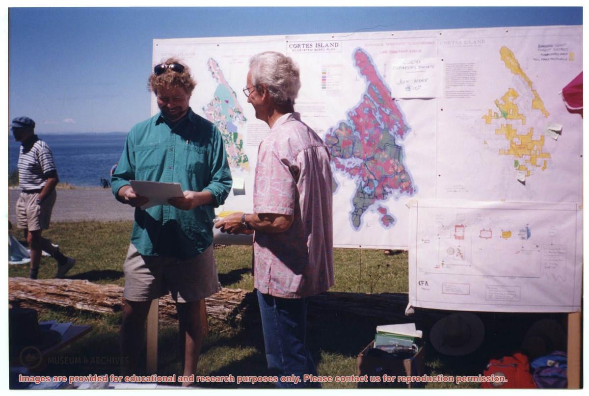
David Shipway and Bruce Ellingsen in front of CES map display at Smelt Bay
Show All Information
David Shipway (L) and Bruce Ellingen in front of CES map display, Smelt Bay
Show All Information
Electrical service: BC Hydro maps and contracts
Part Of
May and Elmer Ellingsen fonds
Description Level
File
Material Type
textual records
Date Range
1984-1985
Scope and Content
File contains BC Hydro maps and contracts with Elmer Ellingsen.
Show All Information
Electrical service: Maps and plans for BC Hydro pole installation and subdivisions
Part Of
May and Elmer Ellingsen fonds
Description Level
File
Material Type
textual records
Date Range
1969-1980
Scope and Content
File contains maps and plans for the installation of power poles, subdivisions, and the school property.
Part Of
May and Elmer Ellingsen fonds
Description Level
File
Fonds Number
2007.001
Series Number
8
File Number
46
Material Type
textual records
Date Range
1969-1980
Scope and Content
File contains maps and plans for the installation of power poles, subdivisions, and the school property.
Storage Location
7-46
Storage Range
7-46
Show less information
Show All Information
Electrical service: road construction standards; maps for electrical pole placement
Part Of
May and Elmer Ellingsen fonds
Description Level
File
Material Type
textual records
Date Range
1980-1986
Scope and Content
File contains a guide to road constructions standards, and a map for the placement of electrical poles for B.C. Hydro.
Part Of
May and Elmer Ellingsen fonds
Description Level
File
Fonds Number
2007.001
Series Number
8
File Number
47
Material Type
textual records
Date Range
1980-1986
Scope and Content
File contains a guide to road constructions standards, and a map for the placement of electrical poles for B.C. Hydro.
Storage Location
7-47
Storage Range
7-47
Show less information