Show All Information
Original Certificate of Improvement re pre-emption of NW 1/4 Section 5 by C C Jurgenson
Show All Information
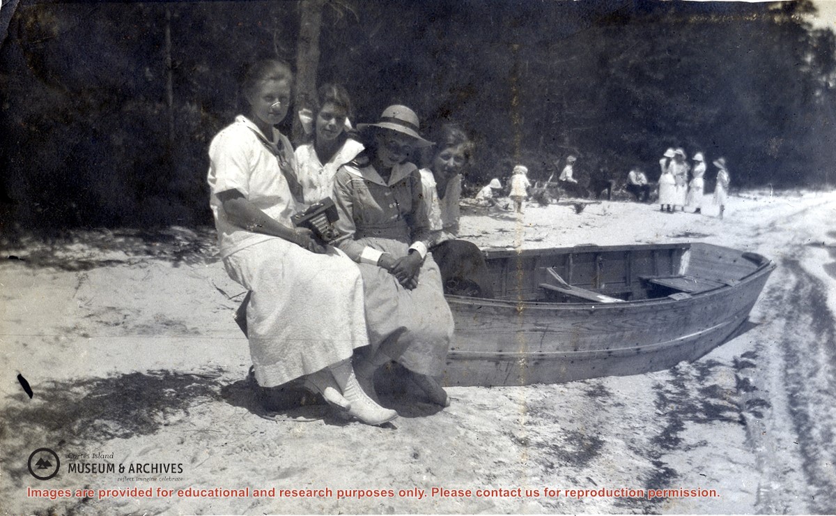
"M. Robertson, M. MIddleton, M. Copland & E. Allen, Manson's Lake, July 1, 1919"
Part Of
Dorothy Huck Whalley fonds
Description Level
Item
Material Type
graphic material
Date Range
1919
Scope and Content
Meg Robertson (Shaw), Margaret Middleton, Margaret Copland and Elsie Allen seated on a beached rowboat at a sandy beach at the lake at Manson's Landing. Other people, including children, can be seen in the background.
Part Of
Dorothy Huck Whalley fonds
Description Level
Item
Creator
Whalley, Dorothy Huck
Fonds Number
2011.001
Series Number
1
Item Number
2011.001.070
Material Type
graphic material
Date Range
1919
Physical Description
1 photograph print: b&w; 10 x 6 cm
Scope and Content
Meg Robertson (Shaw), Margaret Middleton, Margaret Copland and Elsie Allen seated on a beached rowboat at a sandy beach at the lake at Manson's Landing. Other people, including children, can be seen in the background.
Geographic Access
Manson's Landing
Show less information
Show All Information
British Columbia Department of Lands map of Southwestern Districts of BC
Part Of
Gilean Douglas fonds
Description Level
File
Material Type
cartographic material
Date Range
1925
Scope and Content
Coloured map of southwestern BC showing municipalities, geographical features, land and sea routes, natural resources, etc. The back of the map is fully printed with information about BC and suggested travel itineraries.
Map needs preservation: edges are frayed and there are several tears.
Part Of
Gilean Douglas fonds
Description Level
File
Fonds Number
1999.001
Series Number
16
File Number
7
Material Type
cartographic material
Date Range
1925
Physical Description
38 x 36.25 in (31.5 x 80 cm)
Scope and Content
Coloured map of southwestern BC showing municipalities, geographical features, land and sea routes, natural resources, etc. The back of the map is fully printed with information about BC and suggested travel itineraries.
Map needs preservation: edges are frayed and there are several tears.
Storage Location
Map box
Storage Range
Map box
Name Access
Douglas, Gilean
Show less information
Show All Information
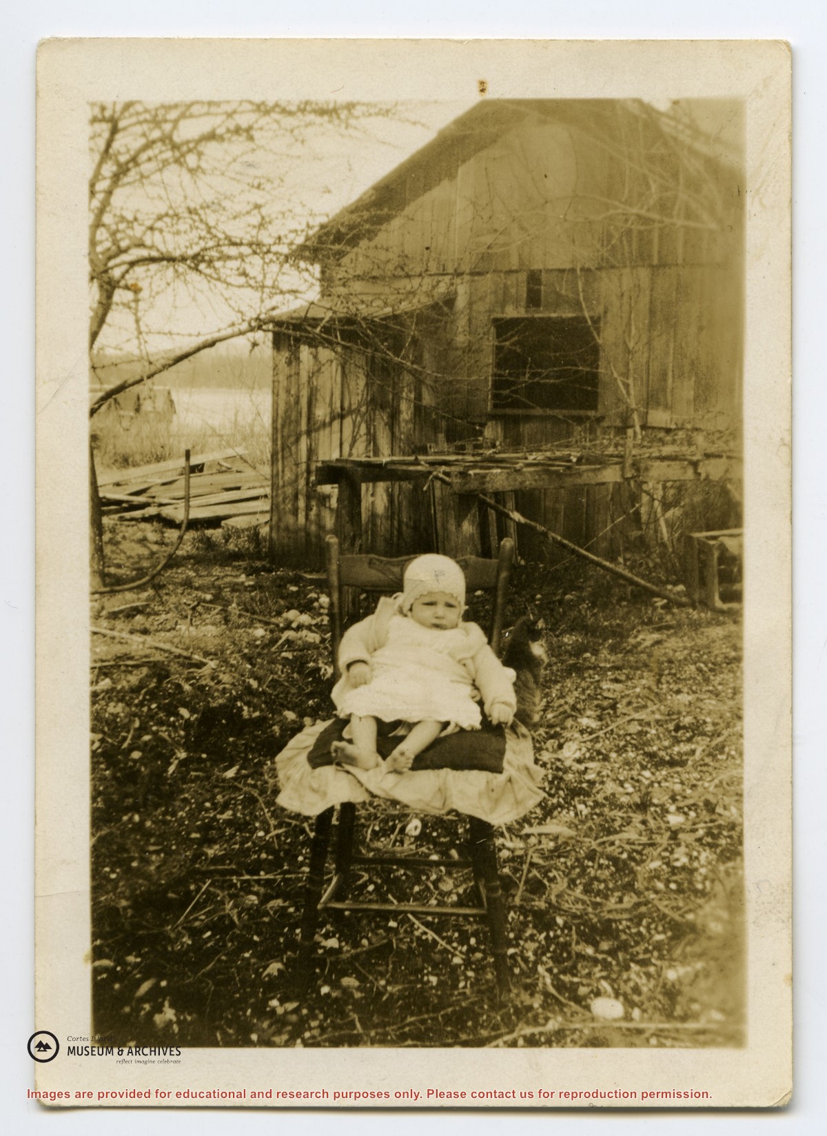
Jim Palmer, less than 1 year old, propped on a chair in front of a building on the Gibson homestead in Squirrel Cove
Part Of
Donald Palmer fonds
Description Level
Item
Material Type
graphic material
Accession Number
2020.002
Date Range
1927
Show All Information
Map of the Northerly Portion of Vancouver Island
Part Of
Gilean Douglas fonds
Description Level
File
Material Type
cartographic material
Date Range
1929
Scope and Content
British Columbia Dept. of Lands map "Northerly Portion of Vancouver Island" showing Crown grants and other land use information
Part Of
Gilean Douglas fonds
Description Level
File
Fonds Number
1999.001
Series Number
16
File Number
1
Material Type
cartographic material
Date Range
1929
Scope and Content
British Columbia Dept. of Lands map "Northerly Portion of Vancouver Island" showing Crown grants and other land use information
Storage Location
6-25
Storage Range
6-25
Name Access
Douglas, Gilean
Show less information
Show All Information
Map of N. Vancouver Island area by the Dept. of Lands and Forests
Part Of
May and Elmer Ellingsen fonds
Description Level
File
Material Type
textual records
cartographic material
Date Range
1948
Scope and Content
File contains
Show All Information
Map of British Columbia highways
Part Of
Gilean Douglas fonds
Description Level
File
Material Type
cartographic material
Date Range
1949
Scope and Content
Map of British Columbia highways with calendar of 1949-1951, published by McLennan McFeely & Prior, Ltd., a shipping company
Part Of
Gilean Douglas fonds
Description Level
File
Fonds Number
1999.001
Series Number
16
File Number
3
Material Type
cartographic material
Date Range
1949
Scope and Content
Map of British Columbia highways with calendar of 1949-1951, published by McLennan McFeely & Prior, Ltd., a shipping company
Storage Location
Map box
Storage Range
Map box
Name Access
Douglas, Gilean
Show less information
Show All Information
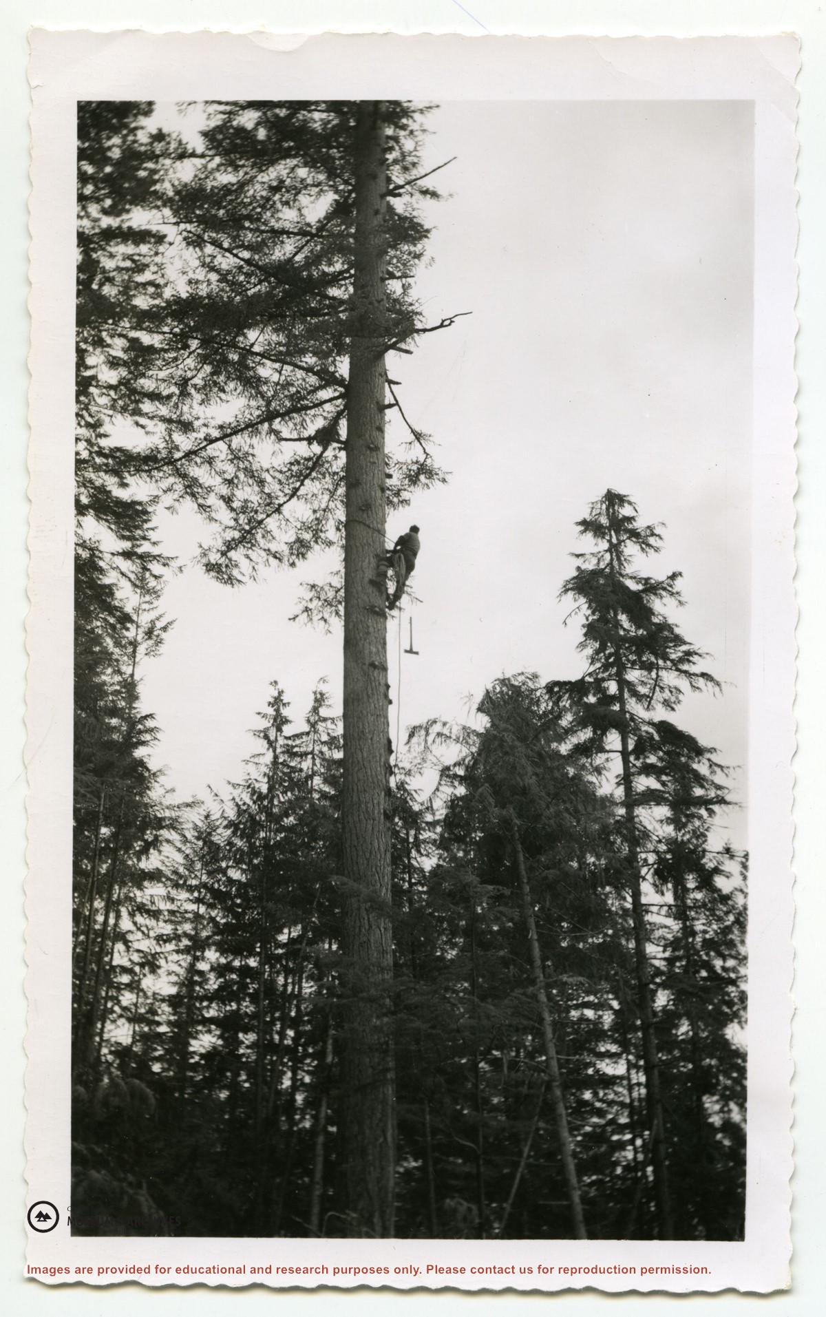
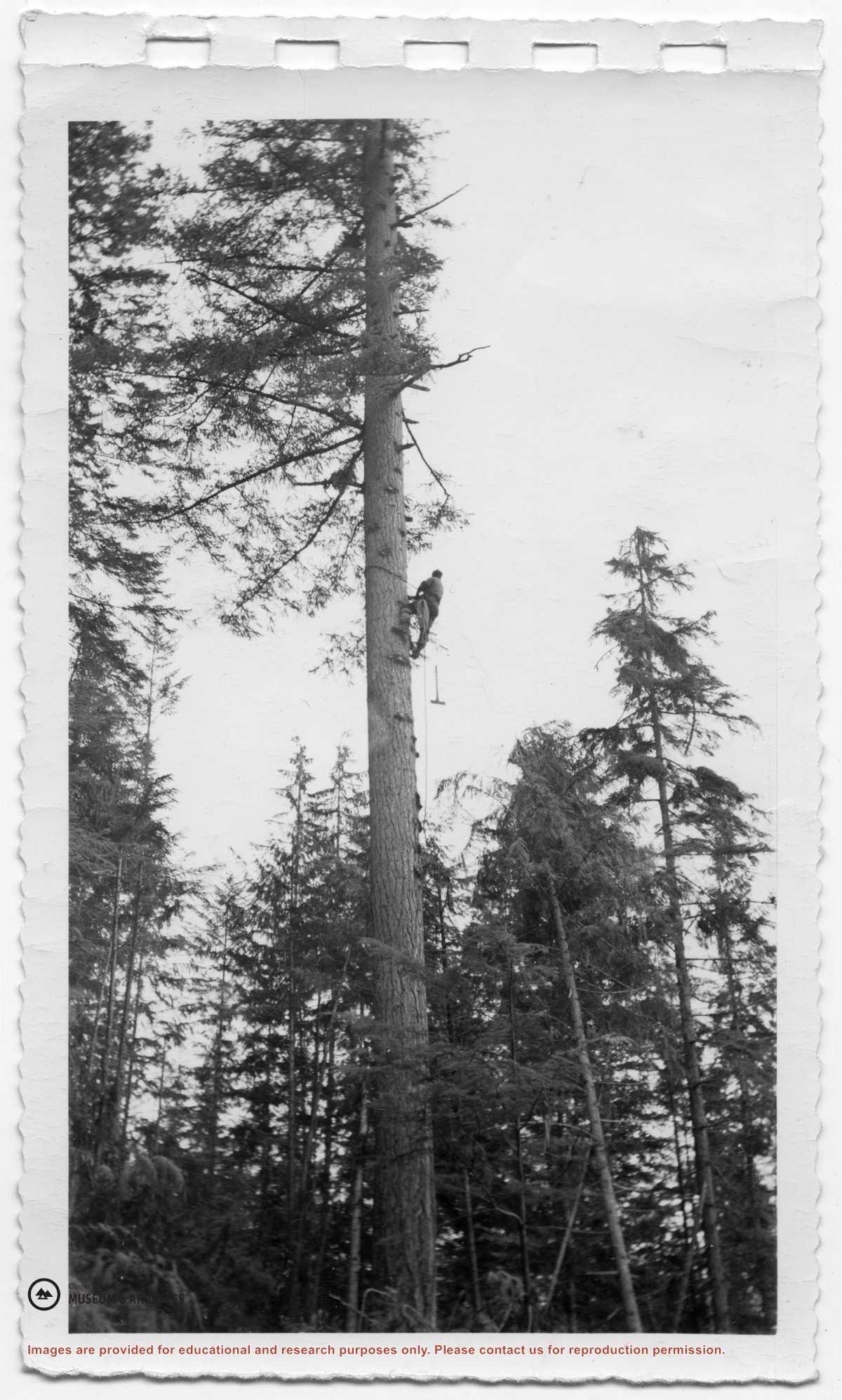
Logger climbing a tall fir tree with an axe and a chainsaw (#1 of a series of 4 photographs)
Part Of
Maclean family fonds
Description Level
Item
Material Type
graphic material
Date Range
1953
Scope and Content
On verso: "Local logging 1953 Whaletown". Duplicate: Item 2003.002.489
Part Of
Maclean family fonds
Description Level
Item
Fonds Number
2019.023
Item Number
2019.023.017
Material Type
graphic material
Date Range
1953
Physical Description
1 photograph print: b&w ; 15 x 9 cm
Scope and Content
On verso: "Local logging 1953 Whaletown". Duplicate: Item 2003.002.489
Storage Location
Photo Box 3
Name Access
Kerr, Janice Maclean
Subject Access
Logging
Geographic Access
Whaletown
Show less information
Show All Information
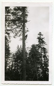
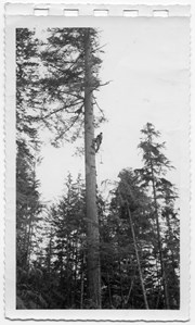
Logger climbing a tall fir tree with an axe and a chainsaw (#1 of a series of 4 photographs) (ID)
Part Of
Mary and Otto Weiler fonds
Description Level
Item
Material Type
graphic material
Date Range
1953
Scope and Content
(Duplicate: Item 2019.023.017)
Show All Information
Map of Section 6/7 on Hague Lake
Part Of
May and Elmer Ellingsen fonds
Description Level
File
Material Type
textual records
Date Range
1953
Scope and Content
File contains a map of Section 6/7 by Hague Lake.
Show All Information
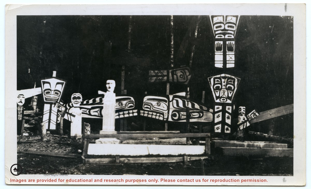
Grave totems of the Newittee Indians on Hope Island (1)
Part Of
Gilean Douglas fonds
Description Level
Item
Material Type
graphic material
Date Range
1954
Scope and Content
Photograph of grave totems of the Newittee on Hope Island.
Show All Information
Sketch of Plan of Proposed Diversion by Department of Highways
Part Of
May and Elmer Ellingsen fonds
Description Level
File
Material Type
textual records
cartographic material
Date Range
1957
Scope and Content
File contains a map of a proposed road diversion at the Arne Anderson property by Gunflint Lake.
Show All Information
Department of Transport "News on the DOT"
Part Of
Gilean Douglas fonds
Description Level
File
Material Type
textual records
Date Range
1963
Scope and Content
March-April 1963 publication of the Dept. of Transport with articles on volunteer Weather Observers
Part Of
Gilean Douglas fonds
Description Level
File
Fonds Number
1999.001
Series Number
9
File Number
36
Material Type
textual records
Date Range
1963
Scope and Content
March-April 1963 publication of the Dept. of Transport with articles on volunteer Weather Observers
Storage Location
4-36
Storage Range
4-36
Name Access
Douglas, Gilean
Show less information
Show All Information
Cortes Island - showing places of interest to our visitors by George Griffin, hand drawn map.
Show All Information
Map of Cortes Island REFILED?? check
Part Of
May and Elmer Ellingsen fonds
Description Level
File
Material Type
textual records
Date Range
1963
Scope and Content
File contains a photo-copy of a hand-drawn map of Cortes Island.
Show All Information
Historic Map of Canada
Part Of
Gilean Douglas fonds
Description Level
File
Material Type
cartographic material
Date Range
1964
Scope and Content
Historic Map of Canada published by Maclean Hunter
Show All Information
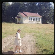
Sarah Weiler walking towards the Whaletown school on her first day of school (Grade 1)
Show All Information
Map of Hernando Island
Part Of
CIMAS ephemera collection
Description Level
File
Date Range
1966
Scope and Content
File contains a hand-drawn map of Hernando Island showing original pre-emptions, with information about settlement, schools and changes of title written on it.
Part Of
CIMAS ephemera collection
Description Level
File
File Number
28
Date Range
1966
Custodial History
Unknown
Scope and Content
File contains a hand-drawn map of Hernando Island showing original pre-emptions, with information about settlement, schools and changes of title written on it.
Storage Location
Ephemera - Box 1
Storage Range
1-28
Geographic Access
Hernando Island
Show less information
Show All Information
Planning seminars for APCs
Show All Information
Electoral Area I Planning study by Regional District of Comox-Strathcona draft report