File contains a page of notes, and photocopies of a tax sale notice (1938) and list of properties forfeited for non-payment of taxes, Crown Grants and other title information for the following:
William Walter James: 1926, Crown Grant for NW 1/4 of Sec. 38; 156 acres for $1.00; forfeited to Crown in 1939
Tom Albinson: 1919, Crown Grant for Lot 867; forfeited in 1927
Sadie McMurray: 1917, NE 1/4 of Sec. 39; 160 acres for $160
Peter Police: 1925, fractional NW 1/4 of Sec. 39; 103 acres for $1.00
(Files 12 through 16 are from the same envelope.)
File contains a key map which was pasted on the front of the envelope indicating the areas researched for Files 12-16; notes on the titles; photocopies of Crown Grants and subsequent title information for:
BC Buildings Corp: 1982, Crown Grant for Block A of SW 1/4 of Sec. 25 (Highways Maintenance Yard)
District Lot 871 (40 acres between Carrington and Coulter Bays): to James Frederick McManus, 1919
To Ernest Henry Vaughn: 1922, Crown Grant for NE 1/4 and NW 1/4 of NE 1/4 of Sec. 24; SE 1/4 of SW 1/4 and SW 1/4 of SE 1/4 of Sec 31
Herbert Proctor: 1928 for fractional SW 1/4 of Sec. 41, bordering Tork Reserve; 159 acres for $159.00 (orig. Crown Grant to Herbert Proctor in 1922)
To William Cowan: 1937, E 1/2 of SE 1/4 of Sec. 26, 89 acres
(Files 12 through 16 are from the same envelope.)
File contains title information and photocopies of land grants and subsequent conveyances for the following:
John Williams: 1914, Crown Grant for the fractional SW 1/4 of Sec 22 and fractional NW 1/4 of Sec 22 (east of Gorge Harbour entrance)
John Williams: 1914, Crown Grant for the fractional SW 1/4 of Sec 22 and frac. NW 1/4 of Sec 18 (west of the Gorge Harbour entrance)
File contains three oversize maps which are stored in the map cabinet: Map of Section 22, Plan VIP52378, Lots A,B,C (blueprint map; 85 cm x 54 cm, 1985); map of Plan 27966 (blueprint map; 55 cm x 43 cm, 1974); photocopy of map of fractional NW 1/4 Sec 17 (55 cm x 43 cm, 1973)
(Files 3 through 7 are from the same envelope.)
File contains a photocopy of Crown Grant and documentation of subsequent changes in title for:
William Barrett Lennard: 1928, Crown Grant for the SE and SW 1/4s of Section 23 (on the SE shore of Gorge Harbour)
(Files 3 through 7 are from the same envelope.)
File contains a photocopy of Crown Grant and documentation of subsequent changes in title for:
William Barrett Lennard: 1928, Crown Grant for the SE and SW 1/4s of Section 23 (on the SE shore of Gorge Harbour)
(Files 3 through 7 are from the same envelope.)
File contains a photocopy of Crown Grant and documentation of subsequent changes in title for:
Eliza Breeze: 1920, Crown Grant for Fractional NW 1/4 of Section 18 (east of the entrance to Gorge Harbour)
(Files 3 through 7 are from the same envelope.)
File contains a photocopy of Crown Grant and documentation of subsequent changes in title for:
Eliza Breeze: 1920, Crown Grant for Fractional NW 1/4 of Section 18 (east of the entrance to Gorge Harbour)
(Files 3 through 7 are from the same envelope.)
File contains a section map showing properties southeast of Gorge Harbour and title information on the property, later owned by Gilean Douglas, and known as Channel Rock.
To John Pool: 1930, Crown Grant of the W 1/2 of the SE 1/4 of Sec. 21 and fractional SW 1/4 of Sec. 21 and Crown Grant fo the fractional E 1/2 of fractional SE 1/4 of Sec. 21
File contains a coloured map with researched properties coloured in, and title information and photocopies of land grants and subsequent conveyances for the following:
Edward James Breeze: 1931, Crown Grant for District Lot 1373 (parts of Section 23 and Section 17, at the southeast end of Gorge Harbour by Anvil Lake)
Frank Harper: 1913, Crown Grant for the NE 96 acres of Section 23 (at the northeast end of Gorge Harbour)
(Files 3 through 7 are from the same envelope.)
File contains title information to 1991 and a photocopy of the original Crown Grant to:
Nicholas Thompson: 1920, Crown Grant of Fractional SW 1/4 of Section 35; 54 acres on the southwest of Whaletown Bay
File contains a small explanatory map if a 5.5 acre portion of fractional SW 1/4 of Sec. 35, 1949, and a Subdivision Plan map of part of fractional SW 1/4 of Sec. 35, 1957 (stored in the Map Cabinet).
(Files 9 and 10 are from the same envelope.)
File contains a map key to the areas of Sections 17, 18, 19, 22 and 34 (south of Gorge Harbour) which were researched (Information in Files 3-7).
It contains photocopies of original land grants and subsequent conveyances for the following:
Reginald James Smith: 1946, Crown Grant 165414I for fractional SE 1/4 of Sec 23, 1946 (the Thunder Road subdivision at the eastern end of Gorge Harbour).
(Files 3 through 7 are from the same envelope.)
File contains photocopies of the original Crown Grants and subsequent title changes with plan maps.
To Moses Ireland: 1893, Crown Grant for the W 1/2 of the SW 1/4 of Section 35 and the fractional SE 1/4 of Section 35 (161 acres around Whaletown Bay
To George Alderson: 1961, Crown Grant for Lot 3 of Section 34
File contains a photocopied part of a map showing the locations of researched property in the Whaletown Lagoon and Whaletown Harbour area. The map is glued to an envelope which has a list of Crown grants and other conveyances on the back.
It contains photocopies of original land grants and other conveyances for the following:
Moses Ireland: 1893, Crown Grant for the W 1/2 of SW 1/4 of Sec 35 and W 1/2 of the SW 1/4 of Section 34
Joseph Youart: 1900, Crown Grant for Fractional NE 1/4 of Sec 35 (sold to Alice Robertson in 1908; "Burnside" is still in the Robertson family).
Nicholas Thompson: 1920, Crown Grant for the Fractional SW 1/4 of Sec 35
Charles Strange: 1914, Crown Grant for the NW 1/4 of Sec 35
File contains information on subdivision and title changes, and a photocopy of the original Crown grant, in the Whaletown Lagoon area, to:
Samuel Thompson: 1894, Crown Grant for SW 1/4 of Section 35 and NW 1/4 of Section 34, 160 acres
File also contains four maps (stored in the Map Cabinet):
1) Subdivision map of part of NE 1/4 of Sec. 34 and part of NE 1/4 of Sec. 34, 1995
2) Subdivision Plan of NW 1/4 of Sec. 34 and NE 1/4 of Sec. 34 and part of E 1/2 of SE 1/2 of Sec. 34, 1995
3) Subdivision Plan of Lot A, NW 1/4 of Sec. 34, 1976
4) Subdivision Plan of part of NW 1/4 of Section 34, 1994
(Files 9 and 10 are from the same envelope.)
File contains a key map and list for the areas researched and information on the following:
George Herbert Wailes: 1920, Crown Grant for fractional SW 1/4 of Sec. 48; 48 acres for $217; with a tax sale notice, 1939
Ina Vernon Munro: 1920, Crown Grant for NE 1/4 of Sec. 37; 161 acres; includes a sale to Hawkins and a forfeit in 1939
Allan Olmsted: 1939, Crown Grant for SW 1/4 of Sec. 37
Ira Furry: 1911, Crown Grant for W 1/2 of SE 1/4 of Sec. 33
Walter Malcolm: 1919, Crown Grant for fractional SW 1/4 of Sec. 36
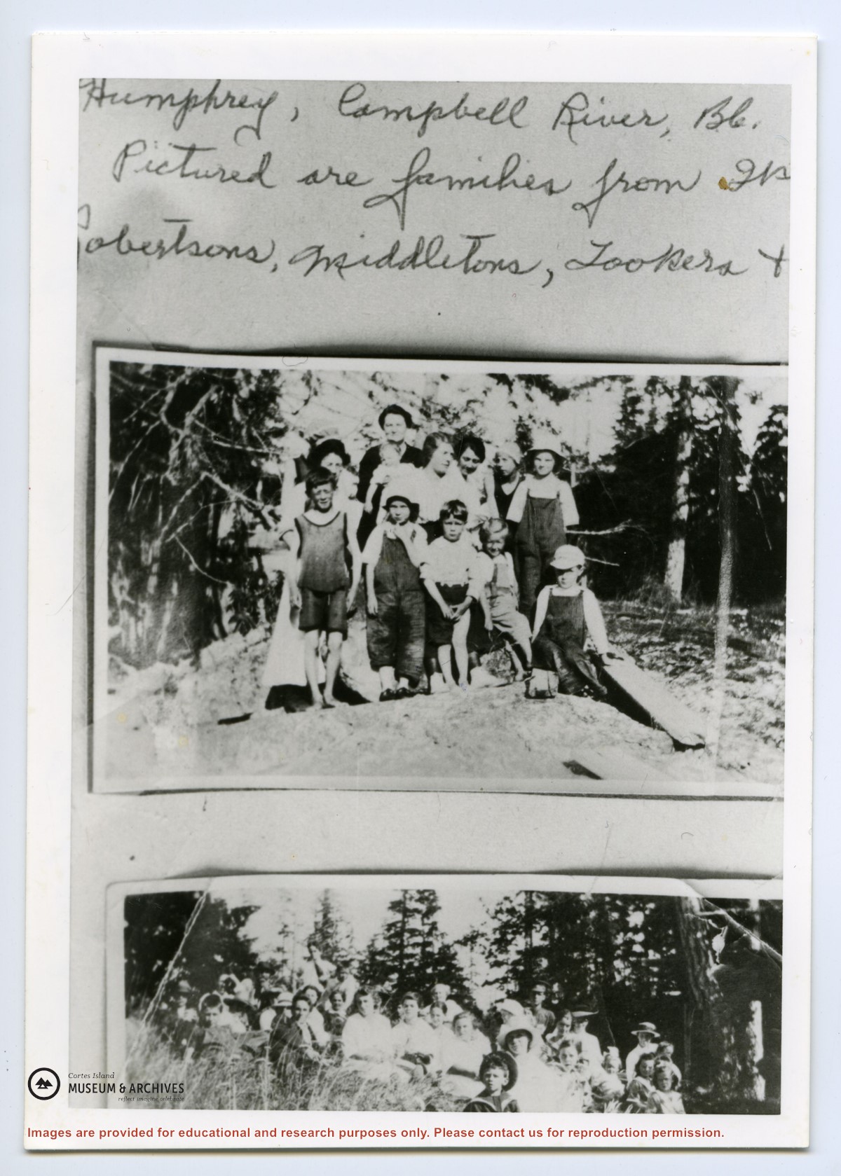
Frank Leslie Tooker: 1926, Crown Grant for N 1/2 of Sec. 36, 124 acres
Ira Furry: 1897, Crown Grant for SE 1/4 of Sec 36; 160 acres for $160.00.
Donald McDonald: 1926, Crown Grant for fractional NW 1/2 of Sec. 37; 144 acres for $1.00
File contains a key map and list for the areas researched and information on the following:
George Herbert Wailes: 1920, Crown Grant for fractional SW 1/4 of Sec. 48; 48 acres for $217; with a tax sale notice, 1939
Ina Vernon Munro: 1920, Crown Grant for NE 1/4 of Sec. 37; 161 acres; includes a sale to Hawkins and a forfeit in 1939
Allan Olmsted: 1939, Crown Grant for SW 1/4 of Sec. 37
Ira Furry: 1911, Crown Grant for W 1/2 of SE 1/4 of Sec. 33
Walter Malcolm: 1919, Crown Grant for fractional SW 1/4 of Sec. 36
Frank Leslie Tooker: 1926, Crown Grant for N 1/2 of Sec. 36, 124 acres
Ira Furry: 1897, Crown Grant for SE 1/4 of Sec 36; 160 acres for $160.00.
Donald McDonald: 1926, Crown Grant for fractional NW 1/2 of Sec. 37; 144 acres for $1.00
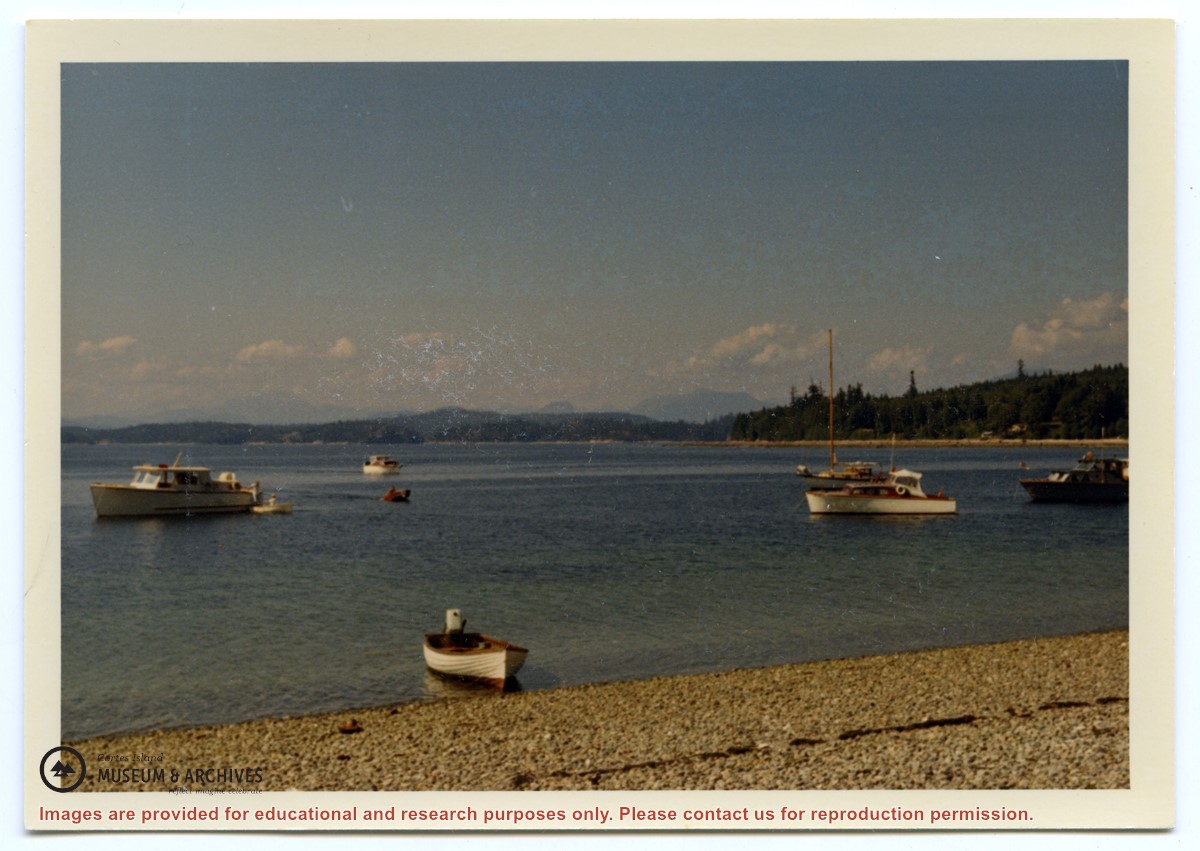
Written info on Carrington Bay and Coulter Bay with info from late 1800s; info from Doris (Houghton-Brown) Henderson on Cortes Island early history, late 1920s. Ian and Mary McMillan's island in Coulter Bay listing, early 1950s. Info about Rendezvous Rock in Coulter Bay, 1953, from CIMAS photo albums. Excerpt from The Columbia is Coming!, Doris Anderson, 1982. Clippings from WNE with info on Coulter Bay, 1982-1992. Typed transcript of written letter from Mary McMillen to Doreen Thompson, undated.
Written info on Carrington Bay and Coulter Bay with info from late 1800s; info from Doris (Houghton-Brown) Henderson on Cortes Island early history, late 1920s. Ian and Mary McMillan's island in Coulter Bay listing, early 1950s. Info about Rendezvous Rock in Coulter Bay, 1953, from CIMAS photo albums. Excerpt from The Columbia is Coming!, Doris Anderson, 1982. Clippings from WNE with info on Coulter Bay, 1982-1992. Typed transcript of written letter from Mary McMillen to Doreen Thompson, undated.
Info on Carrington Bay history and early settler homesteaders from late 1800s onward; scans from Whaletown to 1930 album; scan of location for Department of Energy, Mines and Resources, 1945; park brochure; clippings about Carrington from 1982-2014; excerpt from interview with Clarence and Etta Byers, 2001; notes from exhibit curation (labels, photo captions, etc); excerpts rom June Cameron's Destination Cortez; topographic map of Green Mountain; emails about exhibit; printed photographs for exhibit. Keywords: drowing, Island Timberland, Coulter Bay, stream keepers
Info on Carrington Bay history and early settler homesteaders from late 1800s onward; scans from Whaletown to 1930 album; scan of location for Department of Energy, Mines and Resources, 1945; park brochure; clippings about Carrington from 1982-2014; excerpt from interview with Clarence and Etta Byers, 2001; notes from exhibit curation (labels, photo captions, etc); excerpts rom June Cameron's Destination Cortez; topographic map of Green Mountain; emails about exhibit; printed photographs for exhibit. Keywords: drowing, Island Timberland, Coulter Bay, stream keepers
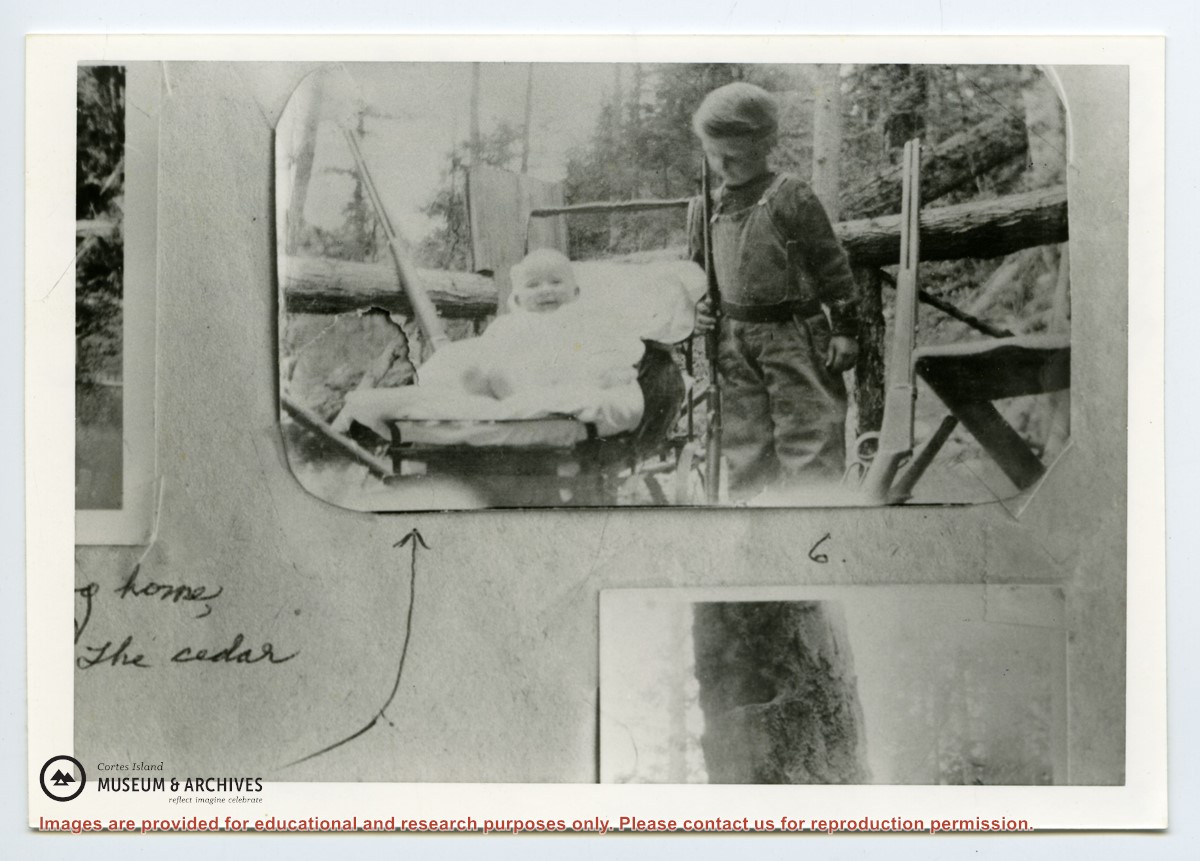
"Note the 38.55 Winchester rifle leaning on porch rail beside Frank. This and the .56 were since referred to as the guns that "won the West". Frank holds a .22 Winchester that got many grouse and some deer. The 38.55 W. was Frank Tooker Sr's and now belongs to grandson Fred Reedel--a keepsake from early days on Cortes Island."
"Note the 38.55 Winchester rifle leaning on porch rail beside Frank. This and the .56 were since referred to as the guns that "won the West". Frank holds a .22 Winchester that got many grouse and some deer. The 38.55 W. was Frank Tooker Sr's and now belongs to grandson Fred Reedel--a keepsake from early days on Cortes Island."
Writing, emails and excerpts with info on early homesteaders, early postmasters, the first post box in Cortes Bay, Frabjous Bay/Frabjous Day, The Columbia Coast Mission, and the Rendezvous. Map of lots with some names of early homesteaders near Cortes Bay. Old postcard of Cortes Bay
Writing, emails and excerpts with info on early homesteaders, early postmasters, the first post box in Cortes Bay, Frabjous Bay/Frabjous Day, The Columbia Coast Mission, and the Rendezvous. Map of lots with some names of early homesteaders near Cortes Bay. Old postcard of Cortes Bay