Series consists of material generated and collected by Douglas during her term on the Comox-Strathcona Regional Board. Douglas served as Alternate Director from 1968 to 1973, and as Director from 1973 to 1978. During this time, island residents were actively involved in the formulation of Cortes' first Official Settlement Plan and Zoning By-law. Series includes reports, correspondence, notes, copies of studies, Regional District by-laws and drafts of by-laws, including the Official Settlement Plan. It also contains materials on community organizations generated after her term which she collected because of a continuing interest in local government and community planning, and because, as a former Director, she was often consulted on island issues.
Series consists of material generated and collected by Douglas during her term on the Comox-Strathcona Regional Board. Douglas served as Alternate Director from 1968 to 1973, and as Director from 1973 to 1978. During this time, island residents were actively involved in the formulation of Cortes' first Official Settlement Plan and Zoning By-law. Series includes reports, correspondence, notes, copies of studies, Regional District by-laws and drafts of by-laws, including the Official Settlement Plan. It also contains materials on community organizations generated after her term which she collected because of a continuing interest in local government and community planning, and because, as a former Director, she was often consulted on island issues.
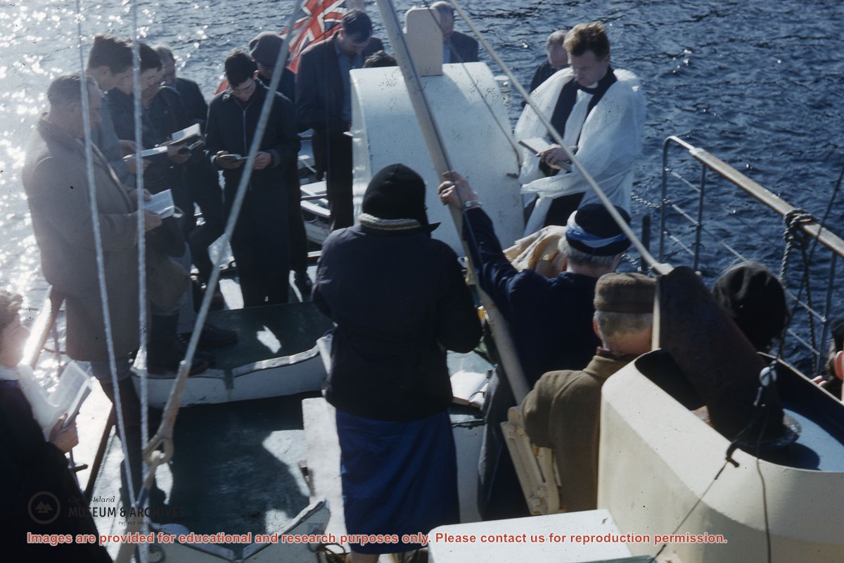
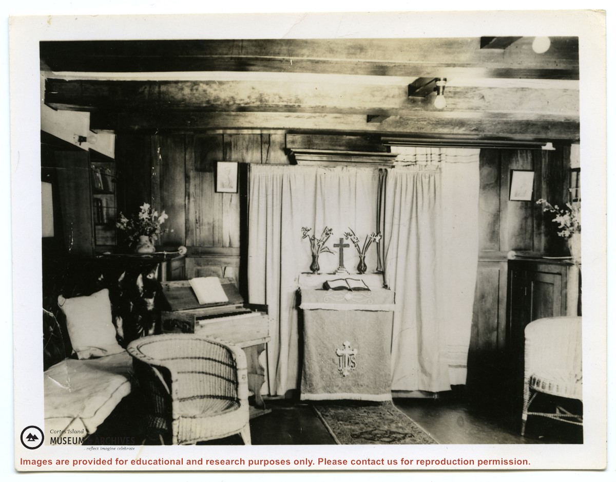
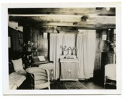
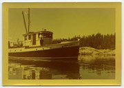
Photograph of the chapel in the cabin of the second "Columbia", with the organ on the left and the portable altar set up for a service. (see "Anderson, Doris, "The Columbia Is Coming"; Gray's Publishing, 1982, photo inset)
2 photograph prints: b&w; 25.6 x 20 and 13 x 10 cm
Scope and Content
Photograph of the chapel in the cabin of the second "Columbia", with the organ on the left and the portable altar set up for a service. (see "Anderson, Doris, "The Columbia Is Coming"; Gray's Publishing, 1982, photo inset)
Series consists of minutes of the School Board concerning Cortes Island schools, correspondence and a school bulletin from the Manson's Landing school collected by Douglas during her term as a school trustee.
Series consists of minutes of the School Board concerning Cortes Island schools, correspondence and a school bulletin from the Manson's Landing school collected by Douglas during her term as a school trustee.
File contains title information and photocopies of land grants and subsequent conveyances for the following:
John Williams: 1914, Crown Grant for the fractional SW 1/4 of Sec 22 and fractional NW 1/4 of Sec 22 (east of Gorge Harbour entrance)
John Williams: 1914, Crown Grant for the fractional SW 1/4 of Sec 22 and frac. NW 1/4 of Sec 18 (west of the Gorge Harbour entrance)
File contains three oversize maps which are stored in the map cabinet: Map of Section 22, Plan VIP52378, Lots A,B,C (blueprint map; 85 cm x 54 cm, 1985); map of Plan 27966 (blueprint map; 55 cm x 43 cm, 1974); photocopy of map of fractional NW 1/4 Sec 17 (55 cm x 43 cm, 1973)
(Files 3 through 7 are from the same envelope.)
File contains a photocopy of Crown Grant and documentation of subsequent changes in title for:
William Barrett Lennard: 1928, Crown Grant for the SE and SW 1/4s of Section 23 (on the SE shore of Gorge Harbour)
(Files 3 through 7 are from the same envelope.)
File contains a photocopy of Crown Grant and documentation of subsequent changes in title for:
William Barrett Lennard: 1928, Crown Grant for the SE and SW 1/4s of Section 23 (on the SE shore of Gorge Harbour)
(Files 3 through 7 are from the same envelope.)
File contains a photocopy of Crown Grant and documentation of subsequent changes in title for:
Eliza Breeze: 1920, Crown Grant for Fractional NW 1/4 of Section 18 (east of the entrance to Gorge Harbour)
(Files 3 through 7 are from the same envelope.)
File contains a photocopy of Crown Grant and documentation of subsequent changes in title for:
Eliza Breeze: 1920, Crown Grant for Fractional NW 1/4 of Section 18 (east of the entrance to Gorge Harbour)
(Files 3 through 7 are from the same envelope.)
File contains a section map showing properties southeast of Gorge Harbour and title information on the property, later owned by Gilean Douglas, and known as Channel Rock.
To John Pool: 1930, Crown Grant of the W 1/2 of the SE 1/4 of Sec. 21 and fractional SW 1/4 of Sec. 21 and Crown Grant fo the fractional E 1/2 of fractional SE 1/4 of Sec. 21
File contains a coloured map with researched properties coloured in, and title information and photocopies of land grants and subsequent conveyances for the following:
Edward James Breeze: 1931, Crown Grant for District Lot 1373 (parts of Section 23 and Section 17, at the southeast end of Gorge Harbour by Anvil Lake)
Frank Harper: 1913, Crown Grant for the NE 96 acres of Section 23 (at the northeast end of Gorge Harbour)
(Files 3 through 7 are from the same envelope.)
File contains title information to 1991 and a photocopy of the original Crown Grant to:
Nicholas Thompson: 1920, Crown Grant of Fractional SW 1/4 of Section 35; 54 acres on the southwest of Whaletown Bay
File contains a small explanatory map if a 5.5 acre portion of fractional SW 1/4 of Sec. 35, 1949, and a Subdivision Plan map of part of fractional SW 1/4 of Sec. 35, 1957 (stored in the Map Cabinet).
(Files 9 and 10 are from the same envelope.)
.jpg?width=1200&404=no-img.jpg&watermark=wmk)
.jpg?width=1200&404=no-img.jpg&watermark=wmk)
.jpg?width=180&404=no-img.jpg)
.jpg?width=1200&404=no-img.jpg&watermark=wmk)
.jpg?width=1200&404=no-img.jpg&watermark=wmk)
.jpg?width=180&404=no-img.jpg)