Hornby Island draft community plan and map
Planning seminars for APCs
APC planning worksheets
Reports of CIRA planning committees
Reports of CIRA planning committees
Cortes Island Community Planning Study
Electoral Area I Planning study by Regional District of Comox-Strathcona draft report
Zoning map of Cortes Island
David Guthrie's map of early Cortes Island property owners
- Part Of
- CIMAS audiovisual collection
- Description Level
- Item
- Material Type
- multiple media
- Accession Number
- 2019.013
- Date Range
- [200?]
- Scope and Content
- CD of a map of early Cortes property owners; a copy of the map is in the map cabinet.
- Part Of
- CIMAS audiovisual collection
- Description Level
- Item
- Creator
- Guthrie, David
- Series Number
- 2
- Item Number
- 2019.013.006
- Accession Number
- 2019.013
- Material Type
- multiple media
- Date Range
- [200?]
- Physical Description
- 1 CD
- Scope and Content
- CD of a map of early Cortes property owners; a copy of the map is in the map cabinet.
- Storage Location
- CD/DVD album
- Geographic Access
- Cortes Island
Show less information
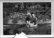
Two women and a dog, swimming at the Gorge Lodge (1)
- Part Of
- Ballantyne family fonds
- Description Level
- Item
- Material Type
- graphic material (electronic)
- Accession Number
- 2020.006
- Date Range
- [ca. 1930]
Cortes Island zoning map, including rezoning requests and four partial maps of Cortes Island showing specific subdivision proposals
Land-use Questionnaire forms, 2 blanks and 1 completed
Zoning maps of Cortes Island: Regional District of Comox-Strathcona zoning maps
Engineering plan for Whaletown ferry terminal
Official Settlement Plan, Cortes Island
Cortes Island - showing places of interest to our visitors by George Griffin, hand drawn map.
Technical guide for preparation of the Official Settlement Plan
Cortes Island Community Plan - preliminary drafts
Cortes Island Community Plan draft revision
Cortes Island Official Settlement Plan, draft