L to R: Kyoshi Kosky, Justin Stirn
Part of a series of 8 photographs which document a clean-up at the proposed Carrington Bay Park site. The squatters' cabin was built in the 1970s, on the east side of Carrington Bay.
L to R: Kyoshi Kosky, Justin Stirn
Part of a series of 8 photographs which document a clean-up at the proposed Carrington Bay Park site. The squatters' cabin was built in the 1970s, on the east side of Carrington Bay.
File contains a key map which was pasted on the front of the envelope indicating the areas researched for Files 12-16; notes on the titles; photocopies of Crown Grants and subsequent title information for:
BC Buildings Corp: 1982, Crown Grant for Block A of SW 1/4 of Sec. 25 (Highways Maintenance Yard)
District Lot 871 (40 acres between Carrington and Coulter Bays): to James Frederick McManus, 1919
To Ernest Henry Vaughn: 1922, Crown Grant for NE 1/4 and NW 1/4 of NE 1/4 of Sec. 24; SE 1/4 of SW 1/4 and SW 1/4 of SE 1/4 of Sec 31
Herbert Proctor: 1928 for fractional SW 1/4 of Sec. 41, bordering Tork Reserve; 159 acres for $159.00 (orig. Crown Grant to Herbert Proctor in 1922)
To William Cowan: 1937, E 1/2 of SE 1/4 of Sec. 26, 89 acres
(Files 12 through 16 are from the same envelope.)
File contains photocopies of original Crown Grants, subsequent title changes and maps for:
To Joseph Gregson: 1926, Crown Grant for fractional W 1/2 of Lot 899 and Lot 901 (between Coulter and Carrington Bays), with a water easement for Wailes
To John Nugent McIllree: 1957, Crown Grant of mineral rights to lots at Coulter Bay surveyed as the "Arrow" and "Bullseye" mineral claims
To Hilda Peterson: 1919, Crown Grant for Lot 878, Carrington Bay, 55 acres
(Files 12 through 16 are from the same envelope.)
File contains a page of notes, and photocopies of a tax sale notice (1938) and list of properties forfeited for non-payment of taxes, Crown Grants and other title information for the following:
William Walter James: 1926, Crown Grant for NW 1/4 of Sec. 38; 156 acres for $1.00; forfeited to Crown in 1939
Tom Albinson: 1919, Crown Grant for Lot 867; forfeited in 1927
Sadie McMurray: 1917, NE 1/4 of Sec. 39; 160 acres for $160
Peter Police: 1925, fractional NW 1/4 of Sec. 39; 103 acres for $1.00
(Files 12 through 16 are from the same envelope.)
File contains information for the following properties:
E. H. Vaughn: 1893, Crown Grant for fractional N 1/2 of Sec. 22; 90 acres for $90.00.
James P. Allen: 1913, Crown Grant for NW 34 acres of Sec. 23; $170.00
Bernard Robinson Allen: 1919, Crown Grant for SW 1/4 of Sec. 23, 159 acres
Charles Allen: 1912, Crown Grant for SW 1/4 of Sec. 33; 160 acres for $160.00
Harold Marshall Wood: Crown Grant for E 1/2 of NE 1/4 of Sec. 46 (east of Carrington Bay); 81 acres for $1.00.
File contains the following maps, stored in the Map Cabinet:
Subdivision Plan of parcel C & E, NW 1/4 of Sec. 21, 1976
Subdivision of the fractional NE 1/4 of Sec 21, 1966; with names of property owners penciled in
Subdivision Plan of Parcel C and part of Parcel E of fractional NE 1/4 of Sec. 21, 1975
Subdivision Plan of fractional NE 1/4 of Sec. 21 and W 1/2 of SW 1/4 of Sec. 34
(Files 17 through 19 are from the same envelope.)
File contains correspondence regarding development in Carrington Bay, between Friends of Cortes Island (FOCI), Regional Director George Sirk, and Klahoose First Nation.
File contains correspondence regarding development in Carrington Bay, between Friends of Cortes Island (FOCI), Regional Director George Sirk, and Klahoose First Nation.
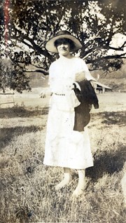
Photograph of Marion Cafferata standing in a clearing in front of a spreading tree. Fields, fences and a building can be seen in the background. The Cafferata family had a homestead at the present-day junction of Carrington Bay Rd. and the old road to Carrington Bay.
Photograph of Marion Cafferata standing in a clearing in front of a spreading tree. Fields, fences and a building can be seen in the background. The Cafferata family had a homestead at the present-day junction of Carrington Bay Rd. and the old road to Carrington Bay.
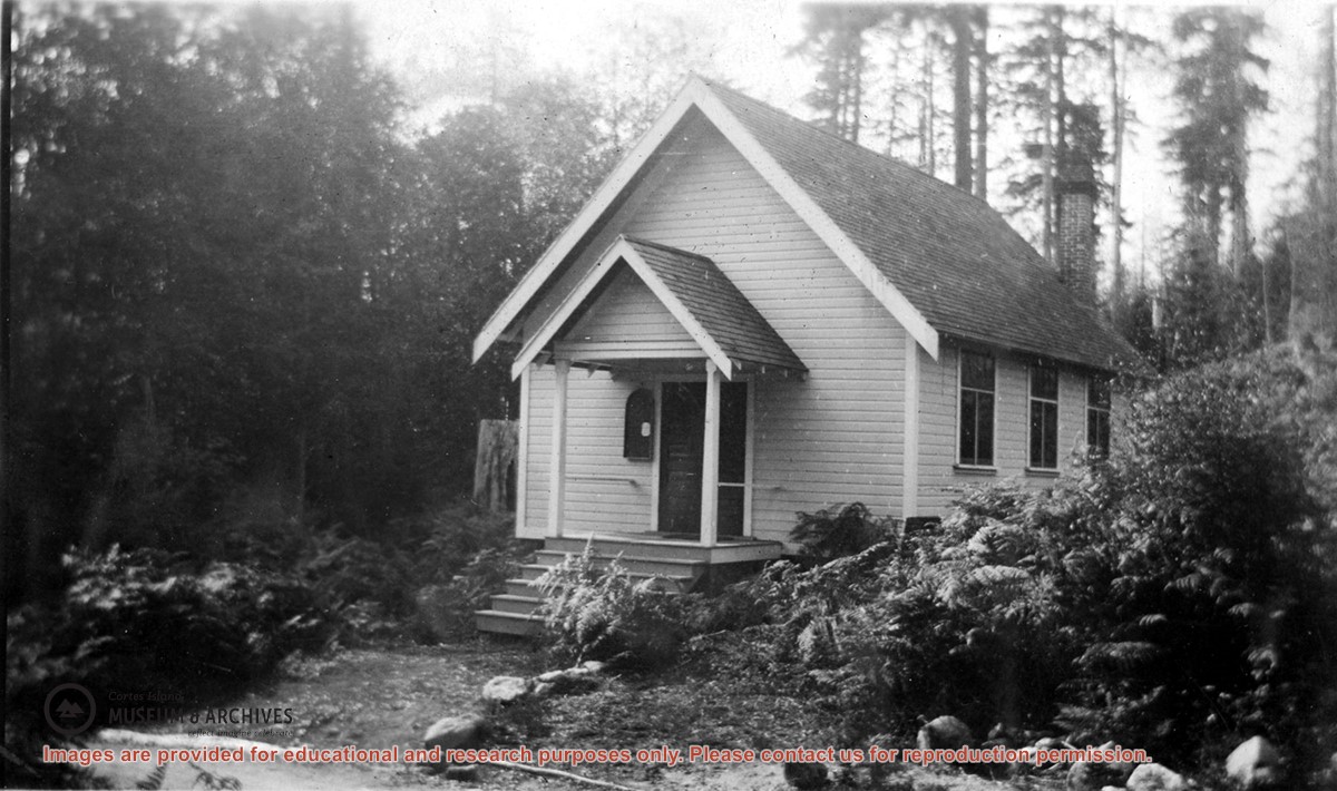
Photograph of the Church Hall in Whaletown, which stood in front of the old cemetery at the corner of Carrington Bay and Harbour roads. It served the community as both church and a venue for social events for almost forty years. The original Whaletown school became its kitchen, and a sleeping place for tired children.
Photograph of the Church Hall in Whaletown, which stood in front of the old cemetery at the corner of Carrington Bay and Harbour roads. It served the community as both church and a venue for social events for almost forty years. The original Whaletown school became its kitchen, and a sleeping place for tired children.
Series consists of records relating to logging on Cortes Island. It includes correspondence, account sheets, Forest Service scale sheets, timber sale maps of Von Donop Creek and Carrington Bay, and copies of Forestry regulations.
Series consists of records relating to logging on Cortes Island. It includes correspondence, account sheets, Forest Service scale sheets, timber sale maps of Von Donop Creek and Carrington Bay, and copies of Forestry regulations.
File consists of records relating to logging done by Freeman and Mathews on crown land near Carrington Bay. It contains account sheets of the log buyer, Forestry scale sheets, statements of expense and maps of the area of logging.
File consists of records relating to logging done by Freeman and Mathews on crown land near Carrington Bay. It contains account sheets of the log buyer, Forestry scale sheets, statements of expense and maps of the area of logging.
Fonds consists of two photograph albums containing 479 black and white photographs with captions, dating from 1916 to 1927. Most of the photographs depict family, friends and scenes from Cortes Island, especially the area known as Green Valley; some photographs show school friends and family from Vancouver and Saskatchewan. Titles in quotation marks are Dorothy Huck's photograph captions. Other information used in photograph descriptions comes from the "Green Valley", "Carrington Bay/Coulter Bay" and "Whaletown to 1930" albums created for CIMAS in 1999 by Doreen Huck Thompson, a grand-niece of Dorothy Huck. Unless otherwise noted, the location of all photos is Cortes Island.
Dorothy Mary Huck Whalley (June 30, 1904 - Nov. 17, 1983) was the oldest of five children born to Mabel Wells Huck and William Edward Huck. Her siblings were Wilfred Harold (Harry), John Edward (Jack), Margaret Ethel and William Frances (Billie). Shortly after the Huck family arrived on Cortes in 1915, William E. Huck enlisted in the Army. He was killed in France in 1916, leaving Mabel with five children to bring up on her own. Her brother, Harold John (Jack) Wells was invalided home from World War I in 1917 and moved to Cortes, where he boarded with Mabel.
The Huck homestead, referred to as Hell's Half Acre or Billy Goat Hill, was in the NE 1/4 of Section 40, in Green Valley, the area around what is now known as Blue Jay Lake. Neighbours included the Barrett, Middleton, Tait and Tiber families. Dorothy was sent to Vancouver for schooling, and then returned to Cortes to attend the new Squirrel Cove school in 1916. In 1920 the Huck family moved to the Robertson property, Burnside, in Whaletown. Dorothy, having outgrown the local school system, went to Moose Jaw, Sk. where she finished high school and then attended a secretarial school run by her aunt and uncle. She married Joe Whalley and lived in Saskatchewan for many years before returning to live in Vancouver and White Rock. Dorothy died in White Rock on Nov. 17, 1983.
Custodial History
The albums were created by Dorothy Huck Whalley and given to her daughter Dorothy Whalley Livingstone. Dorothy Livingstone passed the albums on to her cousin, Karen Lee (daughter of Margaret Huck Mann), who donated them to the Cortes Island Museum & Archives Society.
Scope and Content
Fonds consists of two photograph albums containing 479 black and white photographs with captions, dating from 1916 to 1927. Most of the photographs depict family, friends and scenes from Cortes Island, especially the area known as Green Valley; some photographs show school friends and family from Vancouver and Saskatchewan. Titles in quotation marks are Dorothy Huck's photograph captions. Other information used in photograph descriptions comes from the "Green Valley", "Carrington Bay/Coulter Bay" and "Whaletown to 1930" albums created for CIMAS in 1999 by Doreen Huck Thompson, a grand-niece of Dorothy Huck. Unless otherwise noted, the location of all photos is Cortes Island.
Geographic Access
Cortes Island
Squirrel Cove
Carrington Bay
Saskatchewan
Related Material
"Green Valley", "Carrington Bay/Coulter Bay" and "Whaletown to 1930" albums created by Doreen Huck Thompson.
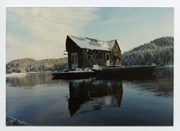
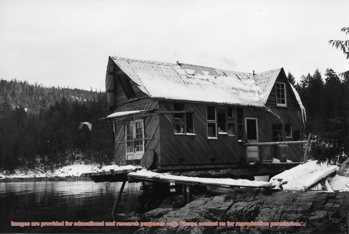
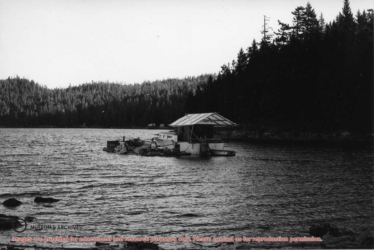
This floathouse was built at John and Anna Gregg's property in Manson's Landing, moved to Carrington Bay beside the entrance to Carrington Lagoon (ca. 1978), and then towed into Gorge Harbour by Bob Thompson with the "Sutil Chief" in 1985.
Transferred from Information Files August 20, 2020
Scope and Content
This floathouse was built at John and Anna Gregg's property in Manson's Landing, moved to Carrington Bay beside the entrance to Carrington Lagoon (ca. 1978), and then towed into Gorge Harbour by Bob Thompson with the "Sutil Chief" in 1985.
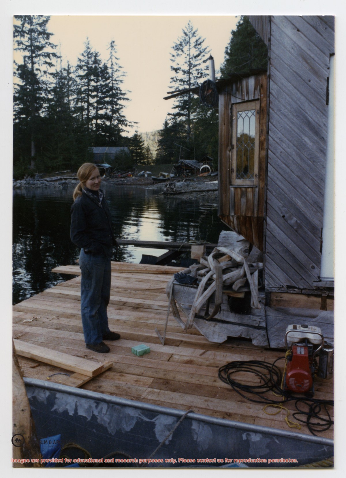
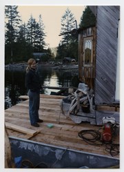
File contains scanned copies of photographs donated by Jim Palmer for the Carrington Bay exhibit in 2009, depicting the community living in Carrington Bay in the 1970s and 1980s.
Jim Palmer and Jan Gemmel lived in a house on the west side of the log jam between Carrington Lagoon and Carrington Bay. Jim built the house at the property of John and Anna Gregg in Manson's Landing and relocated it onto pilings in Carrington Bay. Jim and Jan later fabricated steel pontoons for it. In 1985 the house was moved onto the floats and towed into Gorge Harbour by Bob Thompson with his boat "Sutil Chief".