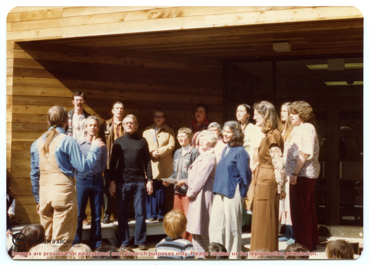
Back, L to R: Bruce Campbell, Duane Campbell, Bonnie Killian, Joan Disney, Peggy Newsham, Wendy Knudson, Kate Hathaway, Donna Norman
Front: David Blinzinger, Conductor; Bruce Ellingsen, Jack Killian, Fay Raymont, Velma Bergman, (ID), Rebecca Campbell
Back, L to R: Bruce Campbell, Duane Campbell, Bonnie Killian, Joan Disney, Peggy Newsham, Wendy Knudson, Kate Hathaway, Donna Norman
Front: David Blinzinger, Conductor; Bruce Ellingsen, Jack Killian, Fay Raymont, Velma Bergman, (ID), Rebecca Campbell
BC gov pamphlets from Victoria: Purchase and Lease of Crown Lands, Travel Bureau, Department of Trade and Industry, 1945; The Acquisition of Crown Lands, Lands Service, Deaprtment of Lands, Forests, and Water Resources, 1962
BC gov pamphlets from Victoria: Purchase and Lease of Crown Lands, Travel Bureau, Department of Trade and Industry, 1945; The Acquisition of Crown Lands, Lands Service, Deaprtment of Lands, Forests, and Water Resources, 1962
Email from Richard Lawton with aerial photographs and map of the Lawton land between Beasley and Cemetery Road, from a meeting on July 18, 2008. 10-part series of articles written by Lawton entitled "The End of an Era," published in the Cortes Marketer, 2013
Email from Richard Lawton with aerial photographs and map of the Lawton land between Beasley and Cemetery Road, from a meeting on July 18, 2008. 10-part series of articles written by Lawton entitled "The End of an Era," published in the Cortes Marketer, 2013
Info on Southern Cortes Community Association, 1956-2017. Info on building a new Manson's community hall, 1978-1979. Clippings, and emails regarding hall, and full issue of The Howling Wolf, 1982-2019. Additional info on history of Manson's hall, grant application, and community hall and tax service.
Info on Southern Cortes Community Association, 1956-2017. Info on building a new Manson's community hall, 1978-1979. Clippings, and emails regarding hall, and full issue of The Howling Wolf, 1982-2019. Additional info on history of Manson's hall, grant application, and community hall and tax service.
Clippings and emails with info on park, 1973-2018. Mansons Landing Provincial Park Master Plan, Province of British Columbia, 1987. Info packet "Fauna and Flora Associated with Manson's Lagoon, a portion of Manson's Landing Park," Fred and Ruth Zwickel, 2003. Info on Robert James Taylor, title holder of Manson's Landing in 1966-1967, received in 2010.
Clippings and emails with info on park, 1973-2018. Mansons Landing Provincial Park Master Plan, Province of British Columbia, 1987. Info packet "Fauna and Flora Associated with Manson's Lagoon, a portion of Manson's Landing Park," Fred and Ruth Zwickel, 2003. Info on Robert James Taylor, title holder of Manson's Landing in 1966-1967, received in 2010.
Historical info packets on history of colonization and early settlers, including info on the park and lagoon, from 1886 onwards. Timeline of early settlers, 1887-1940s. Publications of "Manson's Landing Mirror," Peg Pyner, 1954-1958. Transcribed interviews: Bert and Ken Summers in conversation with Susan Ellingsen, Dianne Hentschel and Doreen Thompson, 2005; Sue Ellingsen, Doreen Thompson, and Dianne Hentschel in conversation with Maryann McCoy, Anne Barton, and Fred Reedel; interview with Barbie Pyner; and interview with Nancy Anderson. Info on Heay Family and George Leask. Excerpts from: The Log, 1940-1946; Goosegrass and Buttercups, D.C. Kirk; The Columbia is Coming; Chalkdust & Outhouses, Barbara Ann Lambert; Seven-Knot Summers, Beth Hill; and PHSC Journal, 2012. Play script, "Gracious Living." Additional info in clippings, handwritten notes, pictures, and emails.
Historical info packets on history of colonization and early settlers, including info on the park and lagoon, from 1886 onwards. Timeline of early settlers, 1887-1940s. Publications of "Manson's Landing Mirror," Peg Pyner, 1954-1958. Transcribed interviews: Bert and Ken Summers in conversation with Susan Ellingsen, Dianne Hentschel and Doreen Thompson, 2005; Sue Ellingsen, Doreen Thompson, and Dianne Hentschel in conversation with Maryann McCoy, Anne Barton, and Fred Reedel; interview with Barbie Pyner; and interview with Nancy Anderson. Info on Heay Family and George Leask. Excerpts from: The Log, 1940-1946; Goosegrass and Buttercups, D.C. Kirk; The Columbia is Coming; Chalkdust & Outhouses, Barbara Ann Lambert; Seven-Knot Summers, Beth Hill; and PHSC Journal, 2012. Play script, "Gracious Living." Additional info in clippings, handwritten notes, pictures, and emails.
Info and photographs on history of businesses in Manson's Landing, from CIMAS "Manson's Landing & Lagoon" photo album, 1880s-1996. Documents for the operation of Manson's Landing store: Grant of Concession and additional documents; mandatory site inspection documents; and tender for operation, 1985. Correspondence re Robert James Taylor, owner of the store in 1966/67.
Info and photographs on history of businesses in Manson's Landing, from CIMAS "Manson's Landing & Lagoon" photo album, 1880s-1996. Documents for the operation of Manson's Landing store: Grant of Concession and additional documents; mandatory site inspection documents; and tender for operation, 1985. Correspondence re Robert James Taylor, owner of the store in 1966/67.
This folder is for the copies of Peg Pyner's column, "Manson's Landing Mirror," containing a wealth of information on local people and daily happenings, 1954-1958
This folder is for the copies of Peg Pyner's column, "Manson's Landing Mirror," containing a wealth of information on local people and daily happenings, 1954-1958
File contains photocopies of original Crown Grants, subsequent title changes and maps for:
To Joseph Gregson: 1926, Crown Grant for fractional W 1/2 of Lot 899 and Lot 901 (between Coulter and Carrington Bays), with a water easement for Wailes
To John Nugent McIllree: 1957, Crown Grant of mineral rights to lots at Coulter Bay surveyed as the "Arrow" and "Bullseye" mineral claims
To Hilda Peterson: 1919, Crown Grant for Lot 878, Carrington Bay, 55 acres
(Files 12 through 16 are from the same envelope.)
File contains a key map which was pasted on the front of the envelope indicating the areas researched for Files 12-16; notes on the titles; photocopies of Crown Grants and subsequent title information for:
BC Buildings Corp: 1982, Crown Grant for Block A of SW 1/4 of Sec. 25 (Highways Maintenance Yard)
District Lot 871 (40 acres between Carrington and Coulter Bays): to James Frederick McManus, 1919
To Ernest Henry Vaughn: 1922, Crown Grant for NE 1/4 and NW 1/4 of NE 1/4 of Sec. 24; SE 1/4 of SW 1/4 and SW 1/4 of SE 1/4 of Sec 31
Herbert Proctor: 1928 for fractional SW 1/4 of Sec. 41, bordering Tork Reserve; 159 acres for $159.00 (orig. Crown Grant to Herbert Proctor in 1922)
To William Cowan: 1937, E 1/2 of SE 1/4 of Sec. 26, 89 acres
(Files 12 through 16 are from the same envelope.)
File contains notes, photocopies of Crown Grants and subsequent title changes for:
William John Sheepwash: 1916, Crown Grant for fractional NE 1/4 of Sec. 45; 153 acres for $153
For Block A of District Lot 744:
-to Gwynn Henry Meredith: 1918, Crown Grant for 59 acres for $1
-to Alfred Edward Layton: 1970, Crown Grant for 59 acres for $460
William Carr Smith: 19??, Crown Grant for District Lot 1170 at Von Donop Creek Lagoon; 155 acres for $1.00
Royal Wells Borden: 1937, Crown Grant for NW 1/4 of Sec 38
(Files 12 through 16 are from the same envelope.)
File contains a photocopy of Crown Grant and documentation of subsequent changes in title for:
Eliza Breeze: 1920, Crown Grant for Fractional NW 1/4 of Section 18 (east of the entrance to Gorge Harbour)
(Files 3 through 7 are from the same envelope.)
File contains a photocopy of Crown Grant and documentation of subsequent changes in title for:
Eliza Breeze: 1920, Crown Grant for Fractional NW 1/4 of Section 18 (east of the entrance to Gorge Harbour)
(Files 3 through 7 are from the same envelope.)
File contains a section map showing properties southeast of Gorge Harbour and title information on the property, later owned by Gilean Douglas, and known as Channel Rock.
To John Pool: 1930, Crown Grant of the W 1/2 of the SE 1/4 of Sec. 21 and fractional SW 1/4 of Sec. 21 and Crown Grant fo the fractional E 1/2 of fractional SE 1/4 of Sec. 21
File contains title information and photocopies of land grants and subsequent conveyances for the following:
John Williams: 1914, Crown Grant for the fractional SW 1/4 of Sec 22 and fractional NW 1/4 of Sec 22 (east of Gorge Harbour entrance)
John Williams: 1914, Crown Grant for the fractional SW 1/4 of Sec 22 and frac. NW 1/4 of Sec 18 (west of the Gorge Harbour entrance)
File contains three oversize maps which are stored in the map cabinet: Map of Section 22, Plan VIP52378, Lots A,B,C (blueprint map; 85 cm x 54 cm, 1985); map of Plan 27966 (blueprint map; 55 cm x 43 cm, 1974); photocopy of map of fractional NW 1/4 Sec 17 (55 cm x 43 cm, 1973)
(Files 3 through 7 are from the same envelope.)