File contains correspondence (including copies of emails and faxes), maps, an Argosy Sea Farms management plan, APC minutes, Director's reports, print-outs of articles from Tideline (www.cortesisland.com), two Discovery Islander magazines (#370 and #371), one Cortes Community flyer and one Cove Notes flyer.
File contains correspondence (including copies of emails and faxes), maps, an Argosy Sea Farms management plan, APC minutes, Director's reports, print-outs of articles from Tideline (www.cortesisland.com), two Discovery Islander magazines (#370 and #371), one Cortes Community flyer and one Cove Notes flyer.
File contains minutes, agendas and other material relating to meetings of the Klahoose Table, attended by members of CILAC, Klahoose First Nations and government negotiators. It includes material relating to a proposed park at Carrington Bay.
File contains minutes, agendas and other material relating to meetings of the Klahoose Table, attended by members of CILAC, Klahoose First Nations and government negotiators. It includes material relating to a proposed park at Carrington Bay.
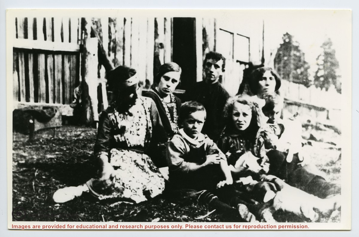
Fonds contains nine photographs depicting members of the Gibson and Palmer families who lived in Squirrel Cove; one large map (6 x 3 feet) showing the preemptions and homesteads of early Cortes settlers; and an account written by Etta (McKay) Byers of her Christmas in 1927.
9 photographs : b&w
1 map : 188 x 92 cm
5 pages of textual records
History / Biographical
Donald Palmer went to school on Cortes Island in the 1960s. His father, James Palmer, was born in 1927 to Elizabeth (Lizzie) and Cliff Palmer, who lived on the homestead of Lizzie's parents, Agnes and James Gibson, in Squirrel Cove. Their large property was on the uphill side of the road across from Tork Road.
Custodial History
Donated to CIMAS in July, 2020, by Donald Palmer
Scope and Content
Fonds contains nine photographs depicting members of the Gibson and Palmer families who lived in Squirrel Cove; one large map (6 x 3 feet) showing the preemptions and homesteads of early Cortes settlers; and an account written by Etta (McKay) Byers of her Christmas in 1927.
Fonds consists of two photograph albums containing 479 black and white photographs with captions, dating from 1916 to 1927. Most of the photographs depict family, friends and scenes from Cortes Island, especially the area known as Green Valley; some photographs show school friends and family from Vancouver and Saskatchewan. Titles in quotation marks are Dorothy Huck's photograph captions. Other information used in photograph descriptions comes from the "Green Valley", "Carrington Bay/Coulter Bay" and "Whaletown to 1930" albums created for CIMAS in 1999 by Doreen Huck Thompson, a grand-niece of Dorothy Huck. Unless otherwise noted, the location of all photos is Cortes Island.
Dorothy Mary Huck Whalley (June 30, 1904 - Nov. 17, 1983) was the oldest of five children born to Mabel Wells Huck and William Edward Huck. Her siblings were Wilfred Harold (Harry), John Edward (Jack), Margaret Ethel and William Frances (Billie). Shortly after the Huck family arrived on Cortes in 1915, William E. Huck enlisted in the Army. He was killed in France in 1916, leaving Mabel with five children to bring up on her own. Her brother, Harold John (Jack) Wells was invalided home from World War I in 1917 and moved to Cortes, where he boarded with Mabel.
The Huck homestead, referred to as Hell's Half Acre or Billy Goat Hill, was in the NE 1/4 of Section 40, in Green Valley, the area around what is now known as Blue Jay Lake. Neighbours included the Barrett, Middleton, Tait and Tiber families. Dorothy was sent to Vancouver for schooling, and then returned to Cortes to attend the new Squirrel Cove school in 1916. In 1920 the Huck family moved to the Robertson property, Burnside, in Whaletown. Dorothy, having outgrown the local school system, went to Moose Jaw, Sk. where she finished high school and then attended a secretarial school run by her aunt and uncle. She married Joe Whalley and lived in Saskatchewan for many years before returning to live in Vancouver and White Rock. Dorothy died in White Rock on Nov. 17, 1983.
Custodial History
The albums were created by Dorothy Huck Whalley and given to her daughter Dorothy Whalley Livingstone. Dorothy Livingstone passed the albums on to her cousin, Karen Lee (daughter of Margaret Huck Mann), who donated them to the Cortes Island Museum & Archives Society.
Scope and Content
Fonds consists of two photograph albums containing 479 black and white photographs with captions, dating from 1916 to 1927. Most of the photographs depict family, friends and scenes from Cortes Island, especially the area known as Green Valley; some photographs show school friends and family from Vancouver and Saskatchewan. Titles in quotation marks are Dorothy Huck's photograph captions. Other information used in photograph descriptions comes from the "Green Valley", "Carrington Bay/Coulter Bay" and "Whaletown to 1930" albums created for CIMAS in 1999 by Doreen Huck Thompson, a grand-niece of Dorothy Huck. Unless otherwise noted, the location of all photos is Cortes Island.
Geographic Access
Cortes Island
Squirrel Cove
Carrington Bay
Saskatchewan
Related Material
"Green Valley", "Carrington Bay/Coulter Bay" and "Whaletown to 1930" albums created by Doreen Huck Thompson.
Fonds consists of records of the Harbour Authority of Cortes Island and includes meeting minutes, financial statements, administrative documents, correspondence, leases and newsletters. Original order has been maintained.
In 1995, Canada's Department of Fisheries and Oceans (DFO) was directed to divest all its recreational harbours managed under the Small Craft Harbours program. In the following years, the DFO launched a program to encourage local non-profit groups to assume day-to-day management and operation of fishing harbours.
The Harbour Authority of Cortes Island was formed in 1998 or 1999 to "[r]epresent the community of Cortes Island to preserve and promote the present and future marine infrastructure and maritime transportation links, including wharves; docking launch and moorage facilities until being replaced by a suitable public representative or government agency".
The Harbour Authority of Cortes Island manages five locations, Cortes Bay, Squirrel Cove Dock, Gorge Harbour Government Dock, Manson’s Landing Dock and Whaletown Dock. All provide safe well-maintained moorage facilities for a wide-ranging group of marine users year round.
Custodial History
Records were donated to CIMAS by Lynne Jordan in 2012.
Scope and Content
Fonds consists of records of the Harbour Authority of Cortes Island and includes meeting minutes, financial statements, administrative documents, correspondence, leases and newsletters. Original order has been maintained.
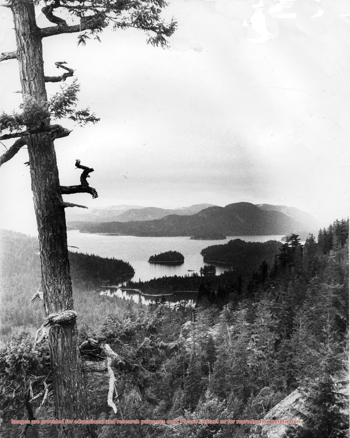
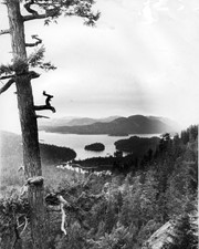
Looking north from Green Mountain over Carrington Lagoon and Carrington Bay (tidal falls in between) across 5 miles of water to Read Island, with a slew of islands to the north.
File contains May Ellingsen's notes on Cortes history, including pre-emptions, a trip to Mexico, and information about Squirrel Cove and Redonda Island.
File contains May Ellingsen's notes on Cortes history, including pre-emptions, a trip to Mexico, and information about Squirrel Cove and Redonda Island.
File contains text of the Memorandum of Understanding developed by Cortes Ecoforestry Society and Klahoose First Nation. Also includes twenty-nine (29) color photographic prints and eleven (11) color inkjet prints, which depict the signing of the MoU at Squirrel Cove and an Ecoforestry display at Smelt Bay. Photographs are stored in Photo Box #3.
File contains text of the Memorandum of Understanding developed by Cortes Ecoforestry Society and Klahoose First Nation. Also includes twenty-nine (29) color photographic prints and eleven (11) color inkjet prints, which depict the signing of the MoU at Squirrel Cove and an Ecoforestry display at Smelt Bay. Photographs are stored in Photo Box #3.
File contains photocopies of original Crown Grants, subsequent title changes and maps for:
To Joseph Gregson: 1926, Crown Grant for fractional W 1/2 of Lot 899 and Lot 901 (between Coulter and Carrington Bays), with a water easement for Wailes
To John Nugent McIllree: 1957, Crown Grant of mineral rights to lots at Coulter Bay surveyed as the "Arrow" and "Bullseye" mineral claims
To Hilda Peterson: 1919, Crown Grant for Lot 878, Carrington Bay, 55 acres
(Files 12 through 16 are from the same envelope.)
File contains a key map which was pasted on the front of the envelope indicating the areas researched for Files 12-16; notes on the titles; photocopies of Crown Grants and subsequent title information for:
BC Buildings Corp: 1982, Crown Grant for Block A of SW 1/4 of Sec. 25 (Highways Maintenance Yard)
District Lot 871 (40 acres between Carrington and Coulter Bays): to James Frederick McManus, 1919
To Ernest Henry Vaughn: 1922, Crown Grant for NE 1/4 and NW 1/4 of NE 1/4 of Sec. 24; SE 1/4 of SW 1/4 and SW 1/4 of SE 1/4 of Sec 31
Herbert Proctor: 1928 for fractional SW 1/4 of Sec. 41, bordering Tork Reserve; 159 acres for $159.00 (orig. Crown Grant to Herbert Proctor in 1922)
To William Cowan: 1937, E 1/2 of SE 1/4 of Sec. 26, 89 acres
(Files 12 through 16 are from the same envelope.)
File contains a page of notes, and photocopies of a tax sale notice (1938) and list of properties forfeited for non-payment of taxes, Crown Grants and other title information for the following:
William Walter James: 1926, Crown Grant for NW 1/4 of Sec. 38; 156 acres for $1.00; forfeited to Crown in 1939
Tom Albinson: 1919, Crown Grant for Lot 867; forfeited in 1927
Sadie McMurray: 1917, NE 1/4 of Sec. 39; 160 acres for $160
Peter Police: 1925, fractional NW 1/4 of Sec. 39; 103 acres for $1.00
(Files 12 through 16 are from the same envelope.)
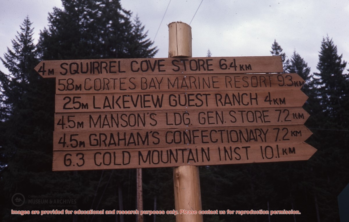
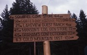
Signpost with directions to Squirrel Cove Store, Cortes Bay Marina, Lakeview Guest Ranch, Manson's Landing General Store, Graham's Confectionary, Cold Mountain Institute