Series consists of articles, maps, correspondence, and notes pertaining to public access of Hank's Beach and surrounding areas on the south end of Cortes Island.
Series consists of articles, maps, correspondence, and notes pertaining to public access of Hank's Beach and surrounding areas on the south end of Cortes Island.
John Manson (1868-1959) was born in the Shetland Islands and migrated to British Columbia in 1887, where he joined his brother Michael Manson on Cortes Island. He married Margaret Ellen Smith in 1894 and they had four children: Jack (born 1896), Anna (1898), Rose (1900) and Nicol (1906). The family lived at Sunny Brae Farm, on the south-east side of Cortes, across from Twin Islands.
Custodial History
Most of the files in this series were in an old wooden box when transferred to the archives, suggesting that they were collected from John Manson's house as a unit.
Scope and Content
Series consists of records created by John Manson of Sunny Brae farm, including legal documents, financial records, correspondence and ephemera.
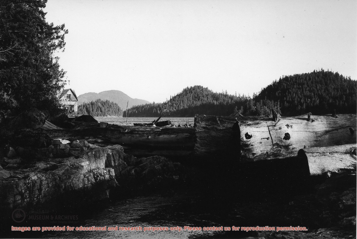
Series consists of 80 photographs with typed explanatory captions, depicting scenes and activities relating to the Manson's Landing school, general scenes of Cortes Island, and James Nixon family of Twin Islands. Many of the the photographs have information written on their backs.
May Ellingsen compiled this album from photographs in the possession of the Manson family and wrote the explanatory captions. The photographs of Manson's school were taken by Katherine Lettice, the teacher at the time; photographs of Twin Islands were taken by the Nixon family, who lived there and were friends of the Manson family. Photographs were turned over to May by Rose or John Manson. Some photographs were in May's possession as her mother, Robina (Manson) Freeman, was a daughter of Michael Manson.
Scope and Content
Series consists of 80 photographs with typed explanatory captions, depicting scenes and activities relating to the Manson's Landing school, general scenes of Cortes Island, and James Nixon family of Twin Islands. Many of the the photographs have information written on their backs.
Series contains records related to work on the Manson's Landing Community Hall in the 1960s, a major expansion and renovation project completed in 1982, and an expansion to add a medical clinic in 1988. It includes plans, grant applications, payroll records, financial reports, receipts, and correspondence.
25 files of textual material
4 photographs : col. ;
2 architectural drawings
Scope and Content
Series contains records related to work on the Manson's Landing Community Hall in the 1960s, a major expansion and renovation project completed in 1982, and an expansion to add a medical clinic in 1988. It includes plans, grant applications, payroll records, financial reports, receipts, and correspondence.
Series contains five maps:(1) Southern half of Cortes Island, BC Ministry of the Environment, 1975, 24" by 36"; (2) Marina Island and part of Gorge Harbour, BC Ministry of the Environment, 1975, 24" by 36"; (3)Cortes Island (West Half), surveyor's map, 1975, 18" by 44"; (4)Cortes Island (East Half), surveyor's map, 1975, 18" by 44"; (5) Cortes Island Coastal Resource Policies, Schedule B, 1987, 14" by 24", scale 1/50,000 - an RDCS planning map showing uses of the foreshore and water surrounding Cortes, with foreshore lease data to 1987.
Series contains five maps:(1) Southern half of Cortes Island, BC Ministry of the Environment, 1975, 24" by 36"; (2) Marina Island and part of Gorge Harbour, BC Ministry of the Environment, 1975, 24" by 36"; (3)Cortes Island (West Half), surveyor's map, 1975, 18" by 44"; (4)Cortes Island (East Half), surveyor's map, 1975, 18" by 44"; (5) Cortes Island Coastal Resource Policies, Schedule B, 1987, 14" by 24", scale 1/50,000 - an RDCS planning map showing uses of the foreshore and water surrounding Cortes, with foreshore lease data to 1987.
Series consists of a hand drawn map of Cortes Island showing places of interest to visitors, maps showing the location of hydro distribution lines on Cortes Island, maps related to zoning and rezoning on Cortes Island, the Official Settlement Plan, and a drawing showing an engineering plan for the Whaletown ferry terminal.
Series consists of a hand drawn map of Cortes Island showing places of interest to visitors, maps showing the location of hydro distribution lines on Cortes Island, maps related to zoning and rezoning on Cortes Island, the Official Settlement Plan, and a drawing showing an engineering plan for the Whaletown ferry terminal.
Series consists of records created or collected by Nursall during his term as Regional Director of Area I (Cortes Island) on the Comox-Strathcona Regional Board. It includes minutes of Advisory Planning Commission, community plans and maps, correspondence, background material and ephemera.
Series is arranged in five subseries following Nursall's original ordering: Advisory Planning Commission; Community Plans; Regional District of Comox-Strathcona: Regional Board; Regional District of Comox-Strathcona: Committees; and Subject Files - Cortes Affairs.
Storage Range
1-1 - 3-3
Related Material
Regional Director of Cortes Island Electoral Area fonds
Series consists of material generated and collected by Douglas during her term on the Comox-Strathcona Regional Board. Douglas served as Alternate Director from 1968 to 1973, and as Director from 1973 to 1978. During this time, island residents were actively involved in the formulation of Cortes' first Official Settlement Plan and Zoning By-law. Series includes reports, correspondence, notes, copies of studies, Regional District by-laws and drafts of by-laws, including the Official Settlement Plan. It also contains materials on community organizations generated after her term which she collected because of a continuing interest in local government and community planning, and because, as a former Director, she was often consulted on island issues.
Series consists of material generated and collected by Douglas during her term on the Comox-Strathcona Regional Board. Douglas served as Alternate Director from 1968 to 1973, and as Director from 1973 to 1978. During this time, island residents were actively involved in the formulation of Cortes' first Official Settlement Plan and Zoning By-law. Series includes reports, correspondence, notes, copies of studies, Regional District by-laws and drafts of by-laws, including the Official Settlement Plan. It also contains materials on community organizations generated after her term which she collected because of a continuing interest in local government and community planning, and because, as a former Director, she was often consulted on island issues.
Series consists of Timber Supply Area documents, including correspondence, newspaper clippings, reports, meeting minutes, maps, management plans, and a development plan.
Series consists of Timber Supply Area documents, including correspondence, newspaper clippings, reports, meeting minutes, maps, management plans, and a development plan.