The base map is a zoning map produced by the Regional District of Comox-
Strathcona for the Cortes Island Land Use Project (Aug 1969). Edwards used
coloured pencil to show land and foreshore zones, and transferred information
about early preemptions and old roads and trails from an earlier map (see
Donald Palmer fonds, 2020.002.011, map of Cortes Island, Sayward District, ca.
1915).
"Robina (Manson) Freeman's picture of baby Magnonie (Magnone?) (6 months old) of Union Bay, Vancouver Island. (Mother a girlhood friend when the Mike Manson family lived there.)
"Robina (Manson) Freeman's picture of baby Magnonie (Magnone?) (6 months old) of Union Bay, Vancouver Island. (Mother a girlhood friend when the Mike Manson family lived there.)
File contains material relating to fare rate increases: background financial information, correspondence, coverage of a protest in Campbell River, interview notes, and a Issue 153 of the Discovery Islander (June 1998) with an article on ferry fares roll-back.
File contains material relating to fare rate increases: background financial information, correspondence, coverage of a protest in Campbell River, interview notes, and a Issue 153 of the Discovery Islander (June 1998) with an article on ferry fares roll-back.
Coloured map of southwestern BC showing municipalities, geographical features, land and sea routes, natural resources, etc. The back of the map is fully printed with information about BC and suggested travel itineraries.
Map needs preservation: edges are frayed and there are several tears.
Coloured map of southwestern BC showing municipalities, geographical features, land and sea routes, natural resources, etc. The back of the map is fully printed with information about BC and suggested travel itineraries.
Map needs preservation: edges are frayed and there are several tears.
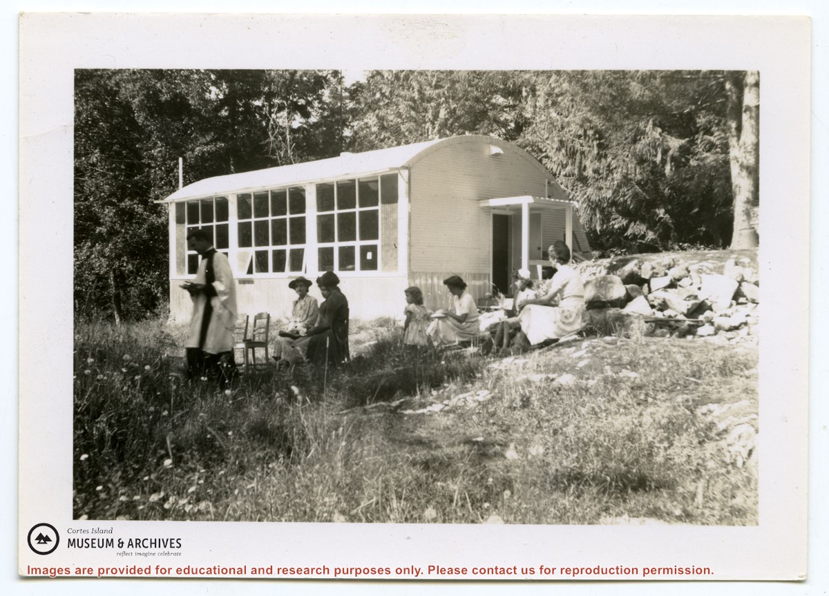
Photograph of Rev. Rollo Boas leading a church service just outside the school building at Surge Narrows on Read Island. Five women and a girl are seated in chairs or on the grass.
Photograph of Rev. Rollo Boas leading a church service just outside the school building at Surge Narrows on Read Island. Five women and a girl are seated in chairs or on the grass.
File contains a help-wanted ad for ferry positions and the third section of the Campbell River Upper Islander (Nov. 26, 1969) with a photo-story on the inaugural trip of the Cortes ferry. On page 3 is "Cortes Grapevine" with an account of Andy and Susan Ellingsen's wedding.
File contains a help-wanted ad for ferry positions and the third section of the Campbell River Upper Islander (Nov. 26, 1969) with a photo-story on the inaugural trip of the Cortes ferry. On page 3 is "Cortes Grapevine" with an account of Andy and Susan Ellingsen's wedding.
.jpg?width=1200&404=no-img.jpg&watermark=wmk)
.jpg?width=1200&404=no-img.jpg&watermark=wmk)
.jpg?width=180&404=no-img.jpg)