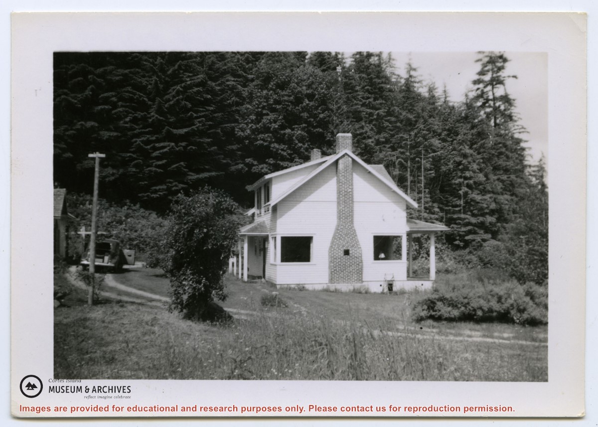
Photograph of two houses. George and Marjorie Griffin's house is in front; pilings for an addition can be seen on the right. Marjorie Griffin is painting the window frames. The house was completed in about 1955/1956 and demolished ca. 2012. To its right and slightly above it is a cottage built by Griffin for his son George and wife Joyce.
2 photograph prints: b&w;16.5 x 11.5 cm (A) and 9 x 6.5 cm (B)
Scope and Content
Photograph of two houses. George and Marjorie Griffin's house is in front; pilings for an addition can be seen on the right. Marjorie Griffin is painting the window frames. The house was completed in about 1955/1956 and demolished ca. 2012. To its right and slightly above it is a cottage built by Griffin for his son George and wife Joyce.
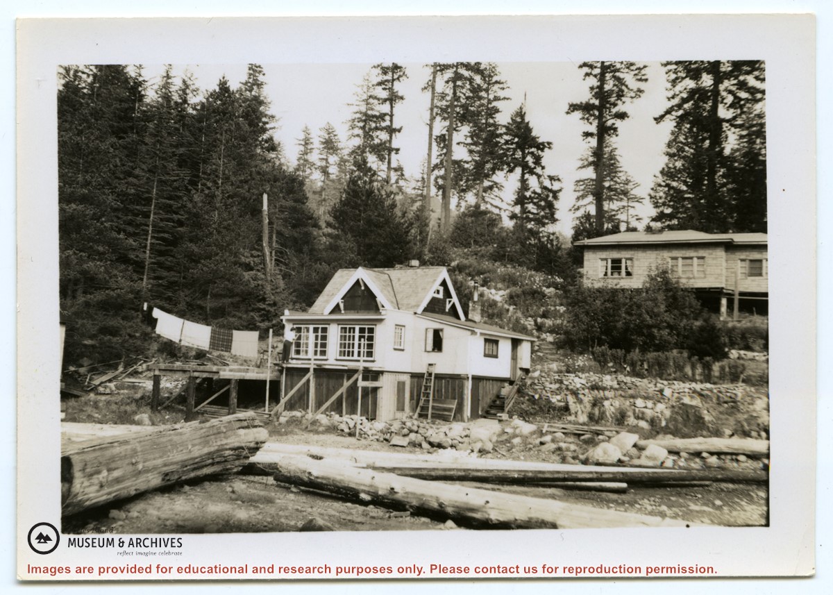
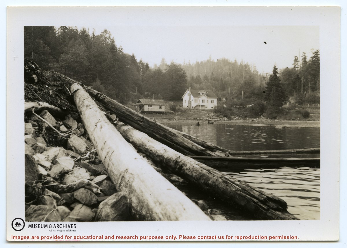
Photograph of the Hayes family house at the head of Cortes Bay. To the left on the beach is a smaller house; to the right a line of laundry is hanging, and a small building (outhouse or smokehouse?) is further to the right. In the foreground some logs are piled on the rocky beach. (same as #1999.001.653)
Photograph of the Hayes family house at the head of Cortes Bay. To the left on the beach is a smaller house; to the right a line of laundry is hanging, and a small building (outhouse or smokehouse?) is further to the right. In the foreground some logs are piled on the rocky beach. (same as #1999.001.653)
File contains a key map which was pasted on the front of the envelope indicating the areas researched for Files 12-16; notes on the titles; photocopies of Crown Grants and subsequent title information for:
BC Buildings Corp: 1982, Crown Grant for Block A of SW 1/4 of Sec. 25 (Highways Maintenance Yard)
District Lot 871 (40 acres between Carrington and Coulter Bays): to James Frederick McManus, 1919
To Ernest Henry Vaughn: 1922, Crown Grant for NE 1/4 and NW 1/4 of NE 1/4 of Sec. 24; SE 1/4 of SW 1/4 and SW 1/4 of SE 1/4 of Sec 31
Herbert Proctor: 1928 for fractional SW 1/4 of Sec. 41, bordering Tork Reserve; 159 acres for $159.00 (orig. Crown Grant to Herbert Proctor in 1922)
To William Cowan: 1937, E 1/2 of SE 1/4 of Sec. 26, 89 acres
(Files 12 through 16 are from the same envelope.)
File contains photocopies of original Crown Grants, subsequent title changes and maps for:
To Joseph Gregson: 1926, Crown Grant for fractional W 1/2 of Lot 899 and Lot 901 (between Coulter and Carrington Bays), with a water easement for Wailes
To John Nugent McIllree: 1957, Crown Grant of mineral rights to lots at Coulter Bay surveyed as the "Arrow" and "Bullseye" mineral claims
To Hilda Peterson: 1919, Crown Grant for Lot 878, Carrington Bay, 55 acres
(Files 12 through 16 are from the same envelope.)
File contains a page of notes, and photocopies of a tax sale notice (1938) and list of properties forfeited for non-payment of taxes, Crown Grants and other title information for the following:
William Walter James: 1926, Crown Grant for NW 1/4 of Sec. 38; 156 acres for $1.00; forfeited to Crown in 1939
Tom Albinson: 1919, Crown Grant for Lot 867; forfeited in 1927
Sadie McMurray: 1917, NE 1/4 of Sec. 39; 160 acres for $160
Peter Police: 1925, fractional NW 1/4 of Sec. 39; 103 acres for $1.00
(Files 12 through 16 are from the same envelope.)
File contains minutes, agendas and other material relating to meetings of the Klahoose Table, attended by members of CILAC, Klahoose First Nations and government negotiators. It includes material relating to a proposed park at Carrington Bay.
File contains minutes, agendas and other material relating to meetings of the Klahoose Table, attended by members of CILAC, Klahoose First Nations and government negotiators. It includes material relating to a proposed park at Carrington Bay.
File consists of the agreement between the Whaletown Women's Institute and the Columbia Coast Mission regarding the use and upkeep of the Church Hall and cemetery at the corner of present-day Carrington Bay and Harbour Rd. in Whaletown.
File consists of the agreement between the Whaletown Women's Institute and the Columbia Coast Mission regarding the use and upkeep of the Church Hall and cemetery at the corner of present-day Carrington Bay and Harbour Rd. in Whaletown.
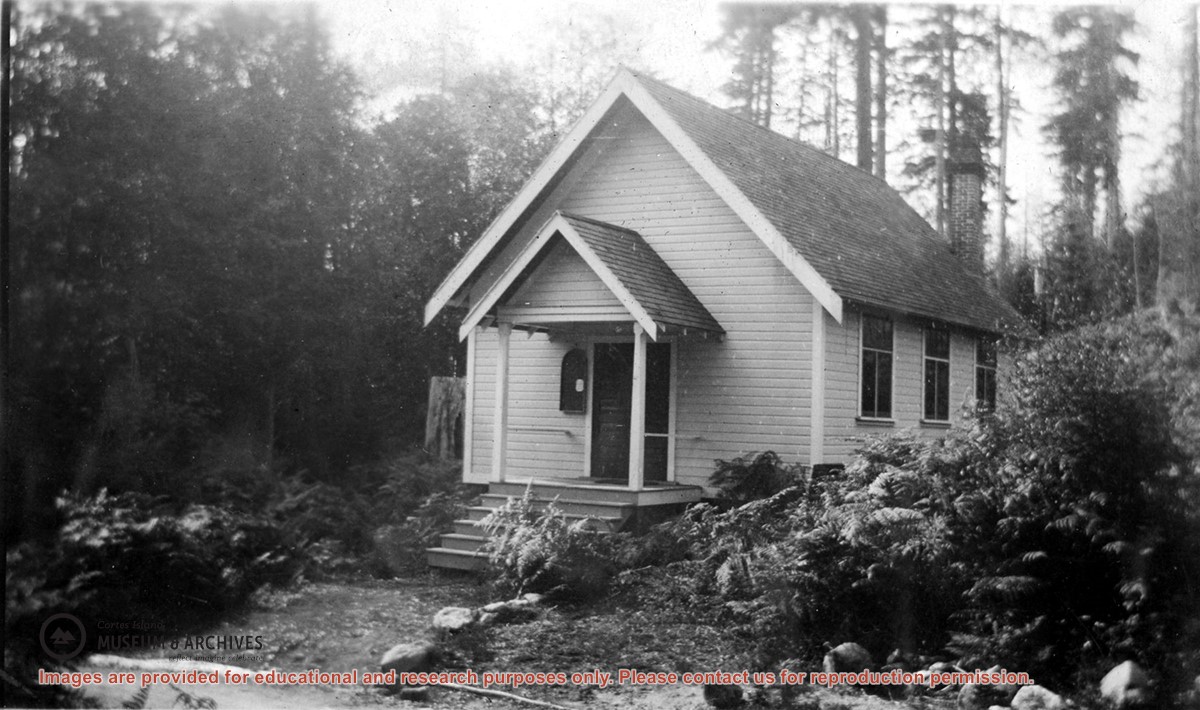
Photograph of the Church Hall in Whaletown, which stood in front of the old cemetery at the corner of Carrington Bay and Harbour roads. It served the community as both church and a venue for social events for almost forty years. The original Whaletown school became its kitchen, and a sleeping place for tired children.
Photograph of the Church Hall in Whaletown, which stood in front of the old cemetery at the corner of Carrington Bay and Harbour roads. It served the community as both church and a venue for social events for almost forty years. The original Whaletown school became its kitchen, and a sleeping place for tired children.
Fonds consists of a minute book and an accounts book of the Whaletown Church Hall Building Fund Committee, documents written by Canon Alan Greene setting out the history, responsibility and terms of use for the Church Hall, and a cover letter for the Certificate of Title from the Land Registry Office.
In 1919, the settlers of Whaletown decided to raise the funds necessary to erect a combined church and hall, to be used for both secular and religious purposes. The new building was attached to the first Whaletown school building, which was then used as a kitchen and dressing room. At this time, the parcel of land on which the school stood, at the corner of present-day Carrington Bay and Harbour Rd. in Whaletown, was deeded to the Diocese of Columbia by Mrs. Alice Robertson, and part of the property was set aside for a cemetery.
After a church was built in Whaletown in 1950, the Church Hall continued to be used for social events. In 1952 the Whaletown Community Club took over responsibility for the Gorge Hall, which then replaced the Church Hall as the main venue for weddings, dances, meetings and parties for both the Whaletown and Gorge Harbour communities. In 1953, the Whaletown Women's Institute signed agreements with both the Whaletown Community Club and the Columbia Coast Mission to assume responsibility for the use and upkeep of the Church Hall and cemetery. The Church Hall was used for a few more years. It was decommissioned in about 1957 and later dismantled.
Custodial History
Canon Alan Greene of the Columbia Coast Mission was involved in the project to build a new Church Hall, and wrote the document setting forth its history and terms of use; envelopes indicate the material was in his possession. Found in a box on the archives shelves; provenance unknown.
Scope and Content
Fonds consists of a minute book and an accounts book of the Whaletown Church Hall Building Fund Committee, documents written by Canon Alan Greene setting out the history, responsibility and terms of use for the Church Hall, and a cover letter for the Certificate of Title from the Land Registry Office.
1999.002 Whaletown Women's Institute fonds
2003.003 Whaletown Community Club fonds
2009.001 Island Women's Club fonds
2011.001 Dorothy Huck Whalley fonds
One of a series of photographs of volunteers removing the remains of shacks at Carrington Bay when Carrington Bay Marine Park was established.
L to R: Cedar DeTrey, Mike ?, John Shook
One of a series of photographs of volunteers removing the remains of shacks at Carrington Bay when Carrington Bay Marine Park was established.
L to R: Cedar DeTrey, Mike ?, John Shook
One of a series of photographs of volunteers removing the remains of shacks at Carrington Bay when Carrington Bay Marine Park was established.
L to R: John Shook, Justin Stirn, Pierre DeTrey, Kiyoshi Kosky, Cedar DeTrey.
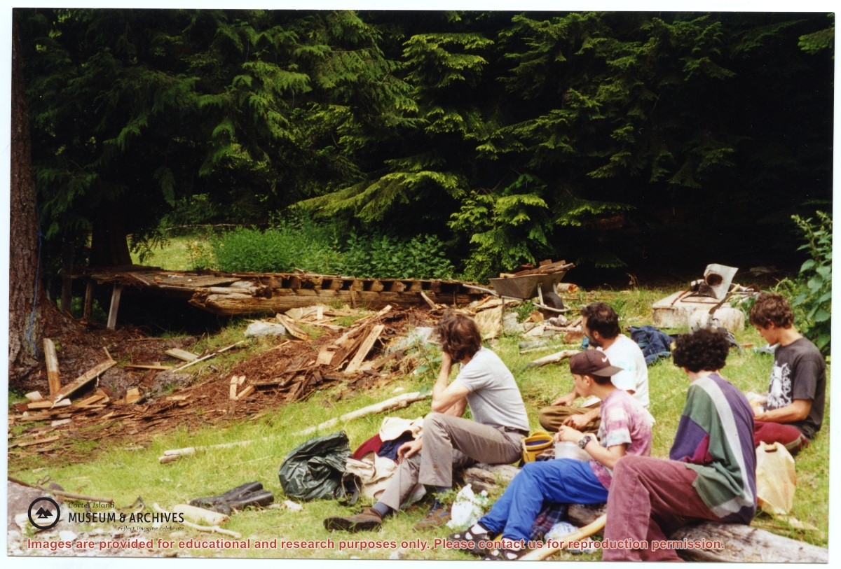
One of a series of photographs of volunteers removing the remains of shacks at Carrington Bay when Carrington Bay Marine Park was established.
L to R: John Shook, Justin Stirn, Pierre DeTrey, Kiyoshi Kosky, Cedar DeTrey.
One of a series of photographs of volunteers removing the remains of shacks at Carrington Bay when Carrington Bay Marine Park was established.
L to R: Kiyoshi Kosky, Pierre DeTrey, Cedar DeTrey
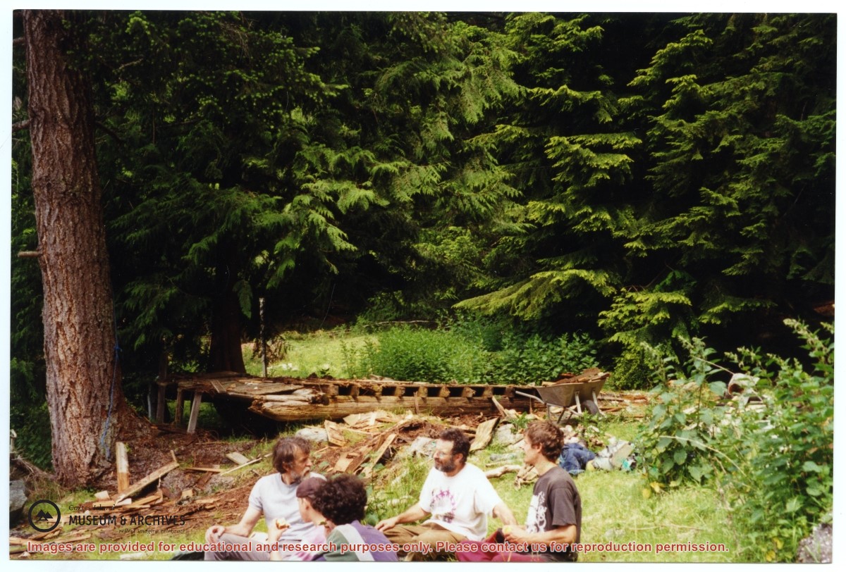
One of a series of photographs of volunteers removing the remains of shacks at Carrington Bay when Carrington Bay Marine Park was established.
L to R: Kiyoshi Kosky, Pierre DeTrey, Cedar DeTrey
L to R: John Shook, Justin Stirn, Pierre DeTrey, Kiyoshi Kosky, Cedar DeTrey
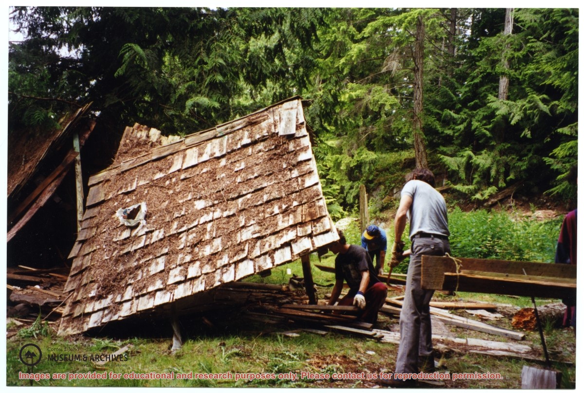
Part of a series of 8 photographs which document a clean-up at the proposed Carrington Bay Park site. The squatters' cabin was built in the 1970s, on the east side of Carrington Bay.
L to R: John Shook, Justin Stirn, Pierre DeTrey, Kiyoshi Kosky, Cedar DeTrey
Part of a series of 8 photographs which document a clean-up at the proposed Carrington Bay Park site. The squatters' cabin was built in the 1970s, on the east side of Carrington Bay.