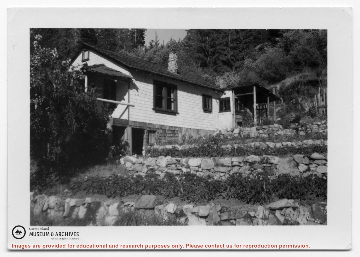
Photograph of a white house with rock-walled terraces to its right. This was Amy and Scotty McKenzie's float house, moved from Von Donop Inlet in 1951. Amy was daughter of Ruth and Henry Byers, who lived in the “Grey House” west of the ferry landing. (The "Grey House" was later moved to Squirrel Cove next to the Store.) The McKenzie house was between the Grey House and the ferry landing; it was torn down ca. 1974. The terraces may still be seen in the small park next to the ferry landing.
Photograph of a white house with rock-walled terraces to its right. This was Amy and Scotty McKenzie's float house, moved from Von Donop Inlet in 1951. Amy was daughter of Ruth and Henry Byers, who lived in the “Grey House” west of the ferry landing. (The "Grey House" was later moved to Squirrel Cove next to the Store.) The McKenzie house was between the Grey House and the ferry landing; it was torn down ca. 1974. The terraces may still be seen in the small park next to the ferry landing.
File contains a key map which was pasted on the front of the envelope indicating the areas researched for Files 12-16; notes on the titles; photocopies of Crown Grants and subsequent title information for:
BC Buildings Corp: 1982, Crown Grant for Block A of SW 1/4 of Sec. 25 (Highways Maintenance Yard)
District Lot 871 (40 acres between Carrington and Coulter Bays): to James Frederick McManus, 1919
To Ernest Henry Vaughn: 1922, Crown Grant for NE 1/4 and NW 1/4 of NE 1/4 of Sec. 24; SE 1/4 of SW 1/4 and SW 1/4 of SE 1/4 of Sec 31
Herbert Proctor: 1928 for fractional SW 1/4 of Sec. 41, bordering Tork Reserve; 159 acres for $159.00 (orig. Crown Grant to Herbert Proctor in 1922)
To William Cowan: 1937, E 1/2 of SE 1/4 of Sec. 26, 89 acres
(Files 12 through 16 are from the same envelope.)
File contains photocopies of original Crown Grants, subsequent title changes and maps for:
To Joseph Gregson: 1926, Crown Grant for fractional W 1/2 of Lot 899 and Lot 901 (between Coulter and Carrington Bays), with a water easement for Wailes
To John Nugent McIllree: 1957, Crown Grant of mineral rights to lots at Coulter Bay surveyed as the "Arrow" and "Bullseye" mineral claims
To Hilda Peterson: 1919, Crown Grant for Lot 878, Carrington Bay, 55 acres
(Files 12 through 16 are from the same envelope.)
File contains a page of notes, and photocopies of a tax sale notice (1938) and list of properties forfeited for non-payment of taxes, Crown Grants and other title information for the following:
William Walter James: 1926, Crown Grant for NW 1/4 of Sec. 38; 156 acres for $1.00; forfeited to Crown in 1939
Tom Albinson: 1919, Crown Grant for Lot 867; forfeited in 1927
Sadie McMurray: 1917, NE 1/4 of Sec. 39; 160 acres for $160
Peter Police: 1925, fractional NW 1/4 of Sec. 39; 103 acres for $1.00
(Files 12 through 16 are from the same envelope.)
File contains information for the following properties:
E. H. Vaughn: 1893, Crown Grant for fractional N 1/2 of Sec. 22; 90 acres for $90.00.
James P. Allen: 1913, Crown Grant for NW 34 acres of Sec. 23; $170.00
Bernard Robinson Allen: 1919, Crown Grant for SW 1/4 of Sec. 23, 159 acres
Charles Allen: 1912, Crown Grant for SW 1/4 of Sec. 33; 160 acres for $160.00
Harold Marshall Wood: Crown Grant for E 1/2 of NE 1/4 of Sec. 46 (east of Carrington Bay); 81 acres for $1.00.
File contains the following maps, stored in the Map Cabinet:
Subdivision Plan of parcel C & E, NW 1/4 of Sec. 21, 1976
Subdivision of the fractional NE 1/4 of Sec 21, 1966; with names of property owners penciled in
Subdivision Plan of Parcel C and part of Parcel E of fractional NE 1/4 of Sec. 21, 1975
Subdivision Plan of fractional NE 1/4 of Sec. 21 and W 1/2 of SW 1/4 of Sec. 34
(Files 17 through 19 are from the same envelope.)
File contains correspondence regarding development in Carrington Bay, between Friends of Cortes Island (FOCI), Regional Director George Sirk, and Klahoose First Nation.
File contains correspondence regarding development in Carrington Bay, between Friends of Cortes Island (FOCI), Regional Director George Sirk, and Klahoose First Nation.
File contains a proposal to MacMillan Bloedel Ltd., regarding the acquisition by the Klahoose First Nation of certain properties located at Squirrel Cove, Cortes Island.
File contains a proposal to MacMillan Bloedel Ltd., regarding the acquisition by the Klahoose First Nation of certain properties located at Squirrel Cove, Cortes Island.
File contains text of the Memorandum of Understanding developed by Cortes Ecoforestry Society and Klahoose First Nation. Also includes twenty-nine (29) color photographic prints and eleven (11) color inkjet prints, which depict the signing of the MoU at Squirrel Cove and an Ecoforestry display at Smelt Bay. Photographs are stored in Photo Box #3.
File contains text of the Memorandum of Understanding developed by Cortes Ecoforestry Society and Klahoose First Nation. Also includes twenty-nine (29) color photographic prints and eleven (11) color inkjet prints, which depict the signing of the MoU at Squirrel Cove and an Ecoforestry display at Smelt Bay. Photographs are stored in Photo Box #3.
Fonds consists of records of the Harbour Authority of Cortes Island and includes meeting minutes, financial statements, administrative documents, correspondence, leases and newsletters. Original order has been maintained.
In 1995, Canada's Department of Fisheries and Oceans (DFO) was directed to divest all its recreational harbours managed under the Small Craft Harbours program. In the following years, the DFO launched a program to encourage local non-profit groups to assume day-to-day management and operation of fishing harbours.
The Harbour Authority of Cortes Island was formed in 1998 or 1999 to "[r]epresent the community of Cortes Island to preserve and promote the present and future marine infrastructure and maritime transportation links, including wharves; docking launch and moorage facilities until being replaced by a suitable public representative or government agency".
The Harbour Authority of Cortes Island manages five locations, Cortes Bay, Squirrel Cove Dock, Gorge Harbour Government Dock, Manson’s Landing Dock and Whaletown Dock. All provide safe well-maintained moorage facilities for a wide-ranging group of marine users year round.
Custodial History
Records were donated to CIMAS by Lynne Jordan in 2012.
Scope and Content
Fonds consists of records of the Harbour Authority of Cortes Island and includes meeting minutes, financial statements, administrative documents, correspondence, leases and newsletters. Original order has been maintained.