This collection consists of ten photograph albums (binders) compiled and annotated by May Ellingsen. The albums contain both original and reproduced photographs of Cortes Island and nearby islands, including Twin Islands and Hernando Island. They are accompanied by captions and additional textual information such as pre-emption records, reminiscences and newspaper clippings. Most of the photographs date from the early decades of the 20th century, depicting homes and buildings, pioneer families, community activities, schools, wharves, boats, logging and marine activity. Fonds consists of two series: Series 1 (The May Ellingsen Historic Photograph Collection, Vol. 1-9, Accession 2004.003) and Series 2 (The Manson Family Album, Accession 2004.002).
Ten photograph albums (binders) containing 152 original photographs and 482 reproductions.
History / Biographical
May Ellingsen was born on March 13, 1914 to George and Robina Freeman. Her maternal grandfather, Michael Manson, was the first person to pre-empt land on Cortes Island, claiming a quarter section on Gunflint Lake in 1886. May spent her childhood on Hernando Island, where her family homesteaded and logged, and on Cortes Island, where she attended the log school at Manson's Landing.
In 1936 May married Elmer Ellingsen. They spent the next ten years in the Loughborough Inlet/Phillips Arm area while Elmer worked for his father's logging operations. During those years their children, Shirley, Bruce and Andy, were born. In 1946 the family moved to Von Donop Creek, where Elmer was logging. In 1950 they moved their float house, built at the time of their marriage, to Manson's Landing Lagoon and two years later, to its present permanent location on Hague Lake.
May and Elmer devoted much time and energy to building their community. Amongst her many community activities, May ran the library at Manson's Hall. She had a strong interest in local history, researching the history of land pre-emptions on the island, collecting and annotating photographs from pioneer families and recording interviews with old timers. She was a founder of the Cortes Island Museum and Archives Society; the archives reading room is named in her honor. Historical materials and artifacts gathered by May formed the kernel of the museum's collections and archives.
Custodial History
May Ellingsen created the albums in the 1980s, and kept adding to them throughout the 1990s. She kept them at the Manson's Landing library and then at the museum from 1999. She officially donated them to CIMAS in 2004.
Scope and Content
This collection consists of ten photograph albums (binders) compiled and annotated by May Ellingsen. The albums contain both original and reproduced photographs of Cortes Island and nearby islands, including Twin Islands and Hernando Island. They are accompanied by captions and additional textual information such as pre-emption records, reminiscences and newspaper clippings. Most of the photographs date from the early decades of the 20th century, depicting homes and buildings, pioneer families, community activities, schools, wharves, boats, logging and marine activity. Fonds consists of two series: Series 1 (The May Ellingsen Historic Photograph Collection, Vol. 1-9, Accession 2004.003) and Series 2 (The Manson Family Album, Accession 2004.002).
File contains a key map which was pasted on the front of the envelope indicating the areas researched for Files 12-16; notes on the titles; photocopies of Crown Grants and subsequent title information for:
BC Buildings Corp: 1982, Crown Grant for Block A of SW 1/4 of Sec. 25 (Highways Maintenance Yard)
District Lot 871 (40 acres between Carrington and Coulter Bays): to James Frederick McManus, 1919
To Ernest Henry Vaughn: 1922, Crown Grant for NE 1/4 and NW 1/4 of NE 1/4 of Sec. 24; SE 1/4 of SW 1/4 and SW 1/4 of SE 1/4 of Sec 31
Herbert Proctor: 1928 for fractional SW 1/4 of Sec. 41, bordering Tork Reserve; 159 acres for $159.00 (orig. Crown Grant to Herbert Proctor in 1922)
To William Cowan: 1937, E 1/2 of SE 1/4 of Sec. 26, 89 acres
(Files 12 through 16 are from the same envelope.)
File contains photocopies of original Crown Grants, subsequent title changes and maps for:
To Joseph Gregson: 1926, Crown Grant for fractional W 1/2 of Lot 899 and Lot 901 (between Coulter and Carrington Bays), with a water easement for Wailes
To John Nugent McIllree: 1957, Crown Grant of mineral rights to lots at Coulter Bay surveyed as the "Arrow" and "Bullseye" mineral claims
To Hilda Peterson: 1919, Crown Grant for Lot 878, Carrington Bay, 55 acres
(Files 12 through 16 are from the same envelope.)
File contains a page of notes, and photocopies of a tax sale notice (1938) and list of properties forfeited for non-payment of taxes, Crown Grants and other title information for the following:
William Walter James: 1926, Crown Grant for NW 1/4 of Sec. 38; 156 acres for $1.00; forfeited to Crown in 1939
Tom Albinson: 1919, Crown Grant for Lot 867; forfeited in 1927
Sadie McMurray: 1917, NE 1/4 of Sec. 39; 160 acres for $160
Peter Police: 1925, fractional NW 1/4 of Sec. 39; 103 acres for $1.00
(Files 12 through 16 are from the same envelope.)
File contains information for the following properties:
E. H. Vaughn: 1893, Crown Grant for fractional N 1/2 of Sec. 22; 90 acres for $90.00.
James P. Allen: 1913, Crown Grant for NW 34 acres of Sec. 23; $170.00
Bernard Robinson Allen: 1919, Crown Grant for SW 1/4 of Sec. 23, 159 acres
Charles Allen: 1912, Crown Grant for SW 1/4 of Sec. 33; 160 acres for $160.00
Harold Marshall Wood: Crown Grant for E 1/2 of NE 1/4 of Sec. 46 (east of Carrington Bay); 81 acres for $1.00.
File contains the following maps, stored in the Map Cabinet:
Subdivision Plan of parcel C & E, NW 1/4 of Sec. 21, 1976
Subdivision of the fractional NE 1/4 of Sec 21, 1966; with names of property owners penciled in
Subdivision Plan of Parcel C and part of Parcel E of fractional NE 1/4 of Sec. 21, 1975
Subdivision Plan of fractional NE 1/4 of Sec. 21 and W 1/2 of SW 1/4 of Sec. 34
(Files 17 through 19 are from the same envelope.)
Fonds consists of material that was gathered by Thompson as she researched island history for museum exhibits and local history albums. It includes land title information about Cortes Island properties going back to the original Crown Grants, correspondence and notes about Cortes Island history, photographs, maps and ephemera.
Fonds is arranged in five series: Land Titles Research; Historical Information; Maps; Photographs; and Ephemera.
30 cm of textual records
40 photographs
12 maps
2 CDs
History / Biographical
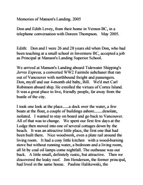
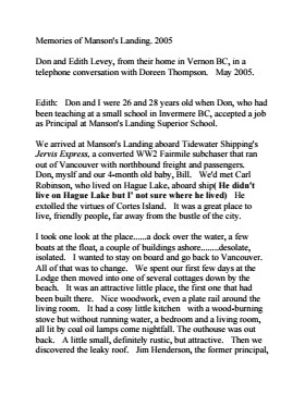
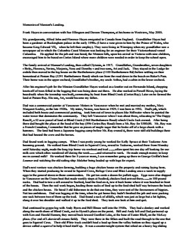
Doreen (Huck) Thompson, 1944-2006:
Doreen’s grandparents, William Edward Huck and Mabel Wells Huck, arrived on Cortes Island in 1915. Widowed in WWI, Mabel and her four children left Cortes for Vancouver in 1923. Her son Harry, Doreen’s father, returned to Cortes in the 1930s. He married Edith Launchbury in 1937 and had two children, Doreen (b.1944) and Ed (b.1945, d.1993). Doreen and Ed were raised in Whaletown and attended school there and at Manson’s Landing.
Doreen graduated from Vic High in Victoria before marrying Bob Thompson in 1962. From 1961 to 1963, Doreen lived in Teakerne Arm in a floathouse Bob had built on the shore of the Whaletown Lagoon and then moved to the shores of Heriot Bay on Quadra Island. Her children were born in 1964 (Janny) and 1965 (Debby). In 1970 the family and the house moved to Cortes Island where both daughters attended school to Grade 10.
Doreen spent a few years living in Alberta and Victoria in the early 1980s and then returned to Cortes Island. Doreen developed a deep knowledge of the history of the island and she devoted considerable time to preserving, gathering and sharing her own and others knowledge of the island through her volunteer work at the Cortes Island Museum and Archives.
Doreen was one of the founders of the Cortes Island Museum. She curated four exhibits at the Museum, including “Windows on Whaletown” in 1999, “Von Donop Inlet”, the commercial fishing portion of “Celebrating Wild Salmon”, and “Memories of Manson’s Landing”. She researched and created albums which combine photographs, reminiscences and clippings to document the history of various island areas, such as Green Valley and Whaletown. The Doreen Thompson Exhibit Gallery at the Museum commemorates her contributions.
Doreen was making a fourth cross-Canada road trip from Cortes to Newfoundland when she was killed in a car accident near Fort McLeod, Alberta on August 1, 2006.
Custodial History
Material was stored at the museum or collected from Doreen Thomas' house.
Scope and Content
Fonds consists of material that was gathered by Thompson as she researched island history for museum exhibits and local history albums. It includes land title information about Cortes Island properties going back to the original Crown Grants, correspondence and notes about Cortes Island history, photographs, maps and ephemera.
Fonds is arranged in five series: Land Titles Research; Historical Information; Maps; Photographs; and Ephemera.
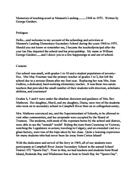
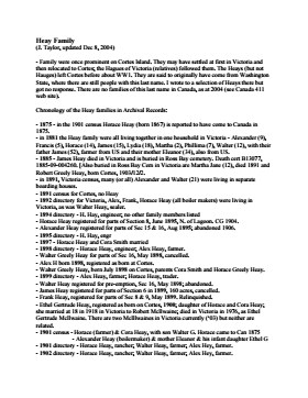
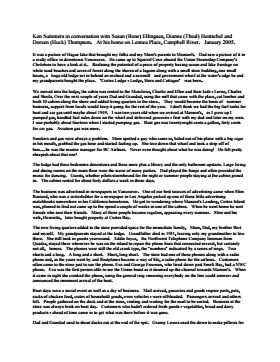
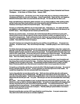
CD (2006.001.041) contains transcripts of interviews with Bert Summers, Beth (Martin) Slater, Betty Jeffery, Bill and Mary Block, Bill Guthrie, Bob Martineau, Don Levey, Frank Hayes, Fred Tomlinson, George Gardner, Heay family, Ken Summers, Otis Coulter, Pat (Fuller) Haines and Violet Herrewig. A Directory List for the CD is in folder 1-41. The transcripts may be viewed on the Archives computer, in the folder "2006.001.041 - Doreen Thompson, interview transcripts".
CD (2006.001.041) contains transcripts of interviews with Bert Summers, Beth (Martin) Slater, Betty Jeffery, Bill and Mary Block, Bill Guthrie, Bob Martineau, Don Levey, Frank Hayes, Fred Tomlinson, George Gardner, Heay family, Ken Summers, Otis Coulter, Pat (Fuller) Haines and Violet Herrewig. A Directory List for the CD is in folder 1-41. The transcripts may be viewed on the Archives computer, in the folder "2006.001.041 - Doreen Thompson, interview transcripts".
Fonds consists of sixteen photographs depicting people and scenes, primarily of the Manson's Landing area. Identification was provided by Fred Brooks Jr. in an interview with Cathy Jenks.
Alethea and Frederick (Fred) James Brooks Sr. and their two sons, Frederick (Fred) Earl, Jr. and Bob, lived on Cortes Island from ca. 1941 to 1944, near Manson's Landing. Fred Sr. logged in Cortes Bay and employed two of the Hawkins boys, Bill and George.
Fred Jr. attended grades three to six at Cortes Island school before the family moved to Pender Harbour. Some of the names he recalls are: the Christiansen kids (Robert, Jim, and a sister), the Tibers on the west side of Cortes Island, and the Jefferys of Smelt Bay.
Custodial History
Fred Brooks Jr. gave the photographs to Cathy Brooks of Pender Harbour Living Heritage Society, who facilitated the donation by collecting the photographs, donation form and information from Brooks and sending the materials to CIMAS.
Scope and Content
Fonds consists of sixteen photographs depicting people and scenes, primarily of the Manson's Landing area. Identification was provided by Fred Brooks Jr. in an interview with Cathy Jenks.
Pender Harbour Living Heritage holds related material from the Brooks family: https://penderharbourheritage.pastperfectonline.com/bysearchterm?keyword=Brooks+family
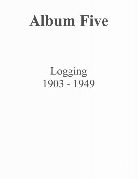
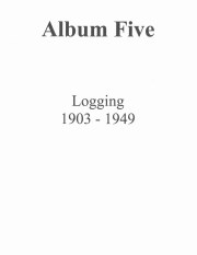
"Logging, 1903-1949":
The album contains reminiscences of Frank Gallinger's logging camp; a photograph of old-growth trees; logging camps (various locations) and group photos; photographs of hand logging with the use of springboards and logging with steam donkeys, tractors, power saws and horses (on the John Manson property); photographs of log booms (various locations), logging on Quadra and "haywire" logging on Hernando Island; and a newspaper clipping about horse logging (1984).
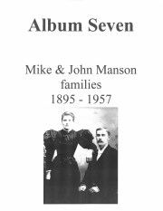
Album Seven: Mike and John Manson families, 1895-1957
Contains: an excerpt from a Victoria Colonist article about Mike Manson's steamship "Thistle" [1907]; log of the "Thistle" [1891; history of Mike Manson's steam tug "Stella"; log of the 'Stella' [1895]; excerpts from the diary of John Manson [1902]; an account of John Manson's funeral by Rev. Alan Greene [1957]; photographs of the Manson family at their home on Cortes Island (McKay, Herrewig, and more...
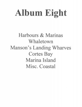
Album 8, "Harbours and Marinas on Cortes Island", contains photographs of wharves and their surroundings in Whaletown, Manson's Landing, Cortes Bay, Marina Island, Camp/Subtle Island, and other nearby coastal areas.
Album 8, "Harbours and Marinas on Cortes Island", contains photographs of wharves and their surroundings in Whaletown, Manson's Landing, Cortes Bay, Marina Island, Camp/Subtle Island, and other nearby coastal areas.
Album 9: Hernando Island and Squirrel Cove
a) Hernando Island: contains a hand-drawn map of Hernando Island, and photographs of the pier, the locomotive used to haul logs, the logging crew at Stag Bay, the George Freeman home at Stag Bay, the logging camp on Hernando Island, residents of Hernando, and the Manson family when they lived at the George Freeman house.
b) Squirrel Cove: contains photographs of the church, the First Nations reservation and residents including the Dominic family, the Forrest family and their store, the Cowan family, the boat shed, planer shed and sawmill which belonged to Val Nichols, the wharf, and the Squirrel Cove Community Hall.
 Slater.pdf?width=280&404=no-doc.jpg)
 Haines.pdf?width=280&404=no-doc.jpg)