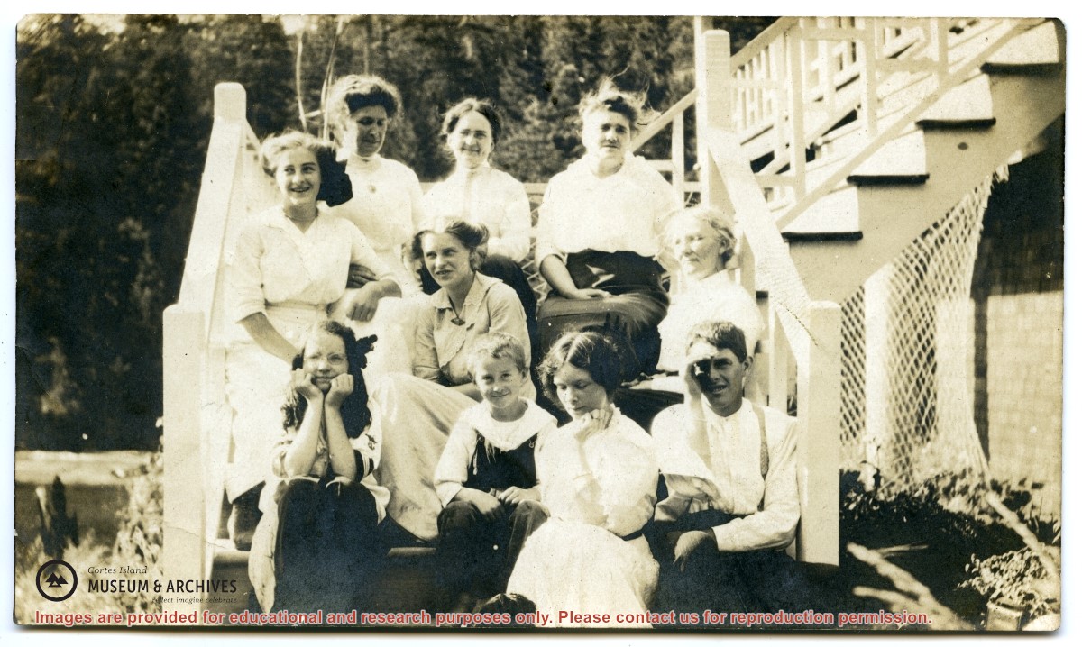
Back, L to R: Mrs. J. Nixon, Mrs. R. McLennan, Mrs. Margaret Manson
Middle, L to R: Rose Manson, Anna Manson, Mrs. H. Hague
Front, L to R: Mabel Lowe, Nicol Manson, Eleanor Hague, Jack Manson
Description taken from May Elllingsen Historic Photograph Album p. 75. Although identified on the back as "taken at John Manson's farm", this was taken at the Nixon home on Twin Island.
Identified on the verso (May Ellingsen's handwriting) as (L to R) Jack Manson, Anna Manson, Beatrice Hawkins, Meg Robertson, Mabel Hawkins.
Jack Manson has his arm in a sling; he had suffered an accident while working in the woods.
Found on shelf, November 2021, in an envelope labelled "Early Days Cortes Island. Enclosed Etta Byers' stuff including her typed story".
Scope and Content
Identified on the verso (May Ellingsen's handwriting) as (L to R) Jack Manson, Anna Manson, Beatrice Hawkins, Meg Robertson, Mabel Hawkins.
Jack Manson has his arm in a sling; he had suffered an accident while working in the woods.
File contains a key map and list for the areas researched and information on the following:
George Herbert Wailes: 1920, Crown Grant for fractional SW 1/4 of Sec. 48; 48 acres for $217; with a tax sale notice, 1939
Ina Vernon Munro: 1920, Crown Grant for NE 1/4 of Sec. 37; 161 acres; includes a sale to Hawkins and a forfeit in 1939
Allan Olmsted: 1939, Crown Grant for SW 1/4 of Sec. 37
Ira Furry: 1911, Crown Grant for W 1/2 of SE 1/4 of Sec. 33
Walter Malcolm: 1919, Crown Grant for fractional SW 1/4 of Sec. 36
Frank Leslie Tooker: 1926, Crown Grant for N 1/2 of Sec. 36, 124 acres
Ira Furry: 1897, Crown Grant for SE 1/4 of Sec 36; 160 acres for $160.00.
Donald McDonald: 1926, Crown Grant for fractional NW 1/2 of Sec. 37; 144 acres for $1.00
Binder contains interviews, stories, clippings and photographs documenting the social history of the Coulter Bay and Carrington Bay areas. It was created as part of the Windows on Whaletown Exhibit, curated and mounted by Doreen Thompson.
Binder contains interviews, stories, clippings and photographs documenting the social history of the Coulter Bay and Carrington Bay areas. It was created as part of the Windows on Whaletown Exhibit, curated and mounted by Doreen Thompson.
File contains articles about Mile Manson; Veronica Dowling; whaling and the Whaletown church by Maud Emery; the opening of the new road between Manson's Landing and Whaletown, Cortes Day Barbecue; the Glad Bag at the Gorge Hall; Chief Billy Mitchell; island life by Holly Arntzen; Cortes Island Day; Gertrude Lambert; Manson's Hall expansion; Gorge Hall expansion; Gilean Douglas.
File contains articles about Mile Manson; Veronica Dowling; whaling and the Whaletown church by Maud Emery; the opening of the new road between Manson's Landing and Whaletown, Cortes Day Barbecue; the Glad Bag at the Gorge Hall; Chief Billy Mitchell; island life by Holly Arntzen; Cortes Island Day; Gertrude Lambert; Manson's Hall expansion; Gorge Hall expansion; Gilean Douglas.
L to R: Kiyoshi Kosky, Justin Stirn, Mike ?, John Shook
Part of a series of 8 photographs which document a clean-up at the proposed Carrington Bay Park site. The squatters' cabin was built in the 1970s, on the east side of Carrington Bay.
L to R: Kiyoshi Kosky, Justin Stirn, Mike ?, John Shook
Part of a series of 8 photographs which document a clean-up at the proposed Carrington Bay Park site. The squatters' cabin was built in the 1970s, on the east side of Carrington Bay.
L to R: John Shook, Justin Stirn, Pierre DeTrey, Kiyoshi Kosky, Cedar DeTrey
Part of a series of 8 photographs which document a clean-up at the proposed Carrington Bay Park site. The squatters' cabin was built in the 1970s, on the east side of Carrington Bay.
L to R: John Shook, Justin Stirn, Pierre DeTrey, Kiyoshi Kosky, Cedar DeTrey
Part of a series of 8 photographs which document a clean-up at the proposed Carrington Bay Park site. The squatters' cabin was built in the 1970s, on the east side of Carrington Bay.
File contains photocopies of original Crown Grants, subsequent title changes and maps for:
To Joseph Gregson: 1926, Crown Grant for fractional W 1/2 of Lot 899 and Lot 901 (between Coulter and Carrington Bays), with a water easement for Wailes
To John Nugent McIllree: 1957, Crown Grant of mineral rights to lots at Coulter Bay surveyed as the "Arrow" and "Bullseye" mineral claims
To Hilda Peterson: 1919, Crown Grant for Lot 878, Carrington Bay, 55 acres
(Files 12 through 16 are from the same envelope.)
L to R: Cedar DeTrey, Mike ?, John Shook
Part of a series of 8 photographs which document a clean-up at the proposed Carrington Bay Park site. The squatters' cabin was built in the 1970s, on the east side of Carrington Bay.
L to R: Cedar DeTrey, Mike ?, John Shook
Part of a series of 8 photographs which document a clean-up at the proposed Carrington Bay Park site. The squatters' cabin was built in the 1970s, on the east side of Carrington Bay.