The base map is a zoning map produced by the Regional District of Comox-
Strathcona for the Cortes Island Land Use Project (Aug 1969). Edwards used
coloured pencil to show land and foreshore zones, and transferred information
about early preemptions and old roads and trails from an earlier map (see
Donald Palmer fonds, 2020.002.011, map of Cortes Island, Sayward District, ca.
1915).
File contains zoning maps for Bylaw 41, Electoral Area I, Schedules A1-A7 with revisions to 1999. There is a map of the whole island and larger scale maps of island areas.
File contains a photocopied section map of the northern part of Cortes Island (from just south of Gorge Harbour), coloured to indicate areas for which a Crown Grant was located and areas of ungranted Crown land which still appear to be owned by the government. Scale is 1 mile to 1 inch.
File contains a photocopied section map of the northern part of Cortes Island (from just south of Gorge Harbour), coloured to indicate areas for which a Crown Grant was located and areas of ungranted Crown land which still appear to be owned by the government. Scale is 1 mile to 1 inch.
File contains a copy of the bylaw and map of 1995, a summary of the changes (meant to reconcile 25 year gap between the previous zoning bylaws and the current OCP), and a completion and adoption strategy.
File contains a copy of the bylaw and map of 1995, a summary of the changes (meant to reconcile 25 year gap between the previous zoning bylaws and the current OCP), and a completion and adoption strategy.
File contains a map key to the areas of Sections 17, 18, 19, 22 and 34 (south of Gorge Harbour) which were researched (Information in Files 3-7).
It contains photocopies of original land grants and subsequent conveyances for the following:
Reginald James Smith: 1946, Crown Grant 165414I for fractional SE 1/4 of Sec 23, 1946 (the Thunder Road subdivision at the eastern end of Gorge Harbour).
(Files 3 through 7 are from the same envelope.)
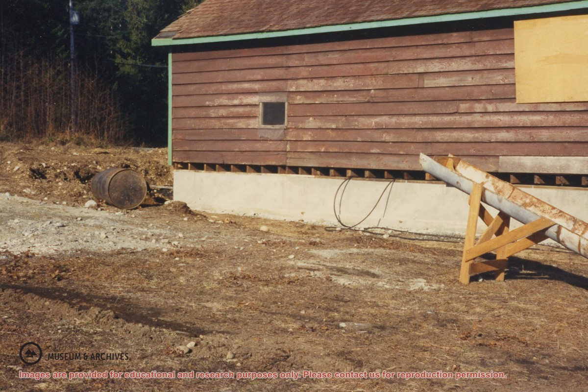
One of a series of 20 photographs documenting the move of the old Manson's Landing store from its position by the wharf in Mansons Landing Provincial Park to the present Museum site on Beasley Rd. The photographs are from an envelope labelled "Moving Museum, Dec. 1995. Moved by Able Transport. Paid for by Elmer and May Ellingsen."
Found in Information Files folder (Cortes Island Museum & Archives info"), Jan. 2021
Scope and Content
One of a series of 20 photographs documenting the move of the old Manson's Landing store from its position by the wharf in Mansons Landing Provincial Park to the present Museum site on Beasley Rd. The photographs are from an envelope labelled "Moving Museum, Dec. 1995. Moved by Able Transport. Paid for by Elmer and May Ellingsen."
Sous-fonds consists of materials generated or gathered by George Sirk during his term as Regional Director. It includes correspondence; minutes and reports of the Cortes Island Advisory Planning Commission (APC); Official Community Plan and Zoning Bylaw revision materials; records of foreshore leases and licenses; correspondence on various island issues, and material relating to parks, aquaculture, forestry, treaty negotiations and other island concerns. Sous-fonds is arranged into six series: Advisory Planning Commission; Community Plans and Bylaws; Regional District of Comox-Strathcona: Regional Board; Regional District of Comox-Strathcona: Committees; Rezoning and Development Proposals; Subject Files: Cortes Affairs; Aquaculture; and Treaty Negotiations.
George Sirk was elected Regional Director of Electoral Area I (Cortes Island) in the Regional District of Comox-Strathcona in 1996. He served three terms as Director, from 1996 to 2005.
Custodial History
Material was donated to CIMAS by George Sirk in 2004, prior to his move from Cortes Island to Victoria, BC.
Scope and Content
Sous-fonds consists of materials generated or gathered by George Sirk during his term as Regional Director. It includes correspondence; minutes and reports of the Cortes Island Advisory Planning Commission (APC); Official Community Plan and Zoning Bylaw revision materials; records of foreshore leases and licenses; correspondence on various island issues, and material relating to parks, aquaculture, forestry, treaty negotiations and other island concerns. Sous-fonds is arranged into six series: Advisory Planning Commission; Community Plans and Bylaws; Regional District of Comox-Strathcona: Regional Board; Regional District of Comox-Strathcona: Committees; Rezoning and Development Proposals; Subject Files: Cortes Affairs; Aquaculture; and Treaty Negotiations.
File contains five maps of Hernando Island: two showing plans of pre-emptions, 1891-1892; two copies of an old hand-drawn map, 1955; and one map of a later proposed development (undated). Some maps have notes on homesteads.
File contains five maps of Hernando Island: two showing plans of pre-emptions, 1891-1892; two copies of an old hand-drawn map, 1955; and one map of a later proposed development (undated). Some maps have notes on homesteads.