Info on: wildfire emergency preparedness; Cortes Volunteer Fire Department and Fire Fighting Association; firehalls; fire trucks; by-laws and funding initiatives concerning fire services on Cortes; helipad and expansion of FD services to handle medical emergencies; fire protection equipement at Klahoose FN; fundraising; and posts relating to local fires and fire fighting responses, 1987-2016
Info on: wildfire emergency preparedness; Cortes Volunteer Fire Department and Fire Fighting Association; firehalls; fire trucks; by-laws and funding initiatives concerning fire services on Cortes; helipad and expansion of FD services to handle medical emergencies; fire protection equipement at Klahoose FN; fundraising; and posts relating to local fires and fire fighting responses, 1987-2016
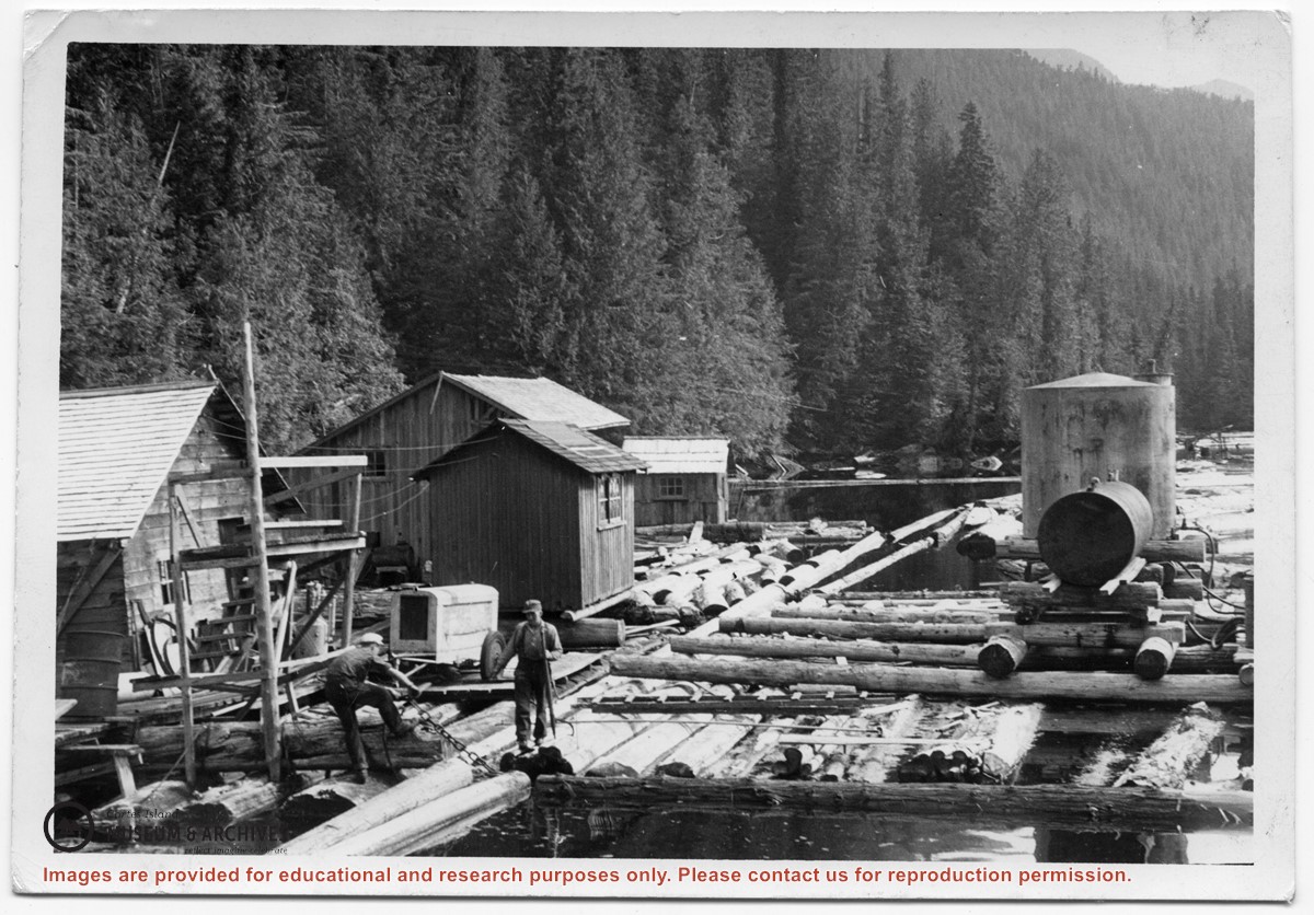
Photograph of two men on floats made of logs chained together, with the buildings, tanks and other paraphernalia of a logging camp on the floats. Location is Seymour Inlet.
Photograph of two men on floats made of logs chained together, with the buildings, tanks and other paraphernalia of a logging camp on the floats. Location is Seymour Inlet.
BC gov pamphlets from Victoria: Purchase and Lease of Crown Lands, Travel Bureau, Department of Trade and Industry, 1945; The Acquisition of Crown Lands, Lands Service, Deaprtment of Lands, Forests, and Water Resources, 1962
BC gov pamphlets from Victoria: Purchase and Lease of Crown Lands, Travel Bureau, Department of Trade and Industry, 1945; The Acquisition of Crown Lands, Lands Service, Deaprtment of Lands, Forests, and Water Resources, 1962
File contains a map key to the areas of Sections 17, 18, 19, 22 and 34 (south of Gorge Harbour) which were researched (Information in Files 3-7).
It contains photocopies of original land grants and subsequent conveyances for the following:
Reginald James Smith: 1946, Crown Grant 165414I for fractional SE 1/4 of Sec 23, 1946 (the Thunder Road subdivision at the eastern end of Gorge Harbour).
(Files 3 through 7 are from the same envelope.)
File contains a cerlox-bound proposal to acquire MacMillan Bloedel lands on Cortes Island, with supporting documents from Klahoose First Nation and The Land Conservancy of BC.
File contains a cerlox-bound proposal to acquire MacMillan Bloedel lands on Cortes Island, with supporting documents from Klahoose First Nation and The Land Conservancy of BC.
Various maps of Cortes Island and surrounding areas with tourist info, trails, provincial parks, local businesses, sites, property lines, topography, charts, etc, 1916-present. Info on Hiking and Orienteering Map of Cortes Island, 2003, and Cortes Island Community Mapping Project, 2011. Info on Discovery Islands Ecosystem Mapping (DIEM), 2012-2014.
Various maps of Cortes Island and surrounding areas with tourist info, trails, provincial parks, local businesses, sites, property lines, topography, charts, etc, 1916-present. Info on Hiking and Orienteering Map of Cortes Island, 2003, and Cortes Island Community Mapping Project, 2011. Info on Discovery Islands Ecosystem Mapping (DIEM), 2012-2014.
Series consists of minutes of the School Board concerning Cortes Island schools, correspondence and a school bulletin from the Manson's Landing school collected by Douglas during her term as a school trustee.
Series consists of minutes of the School Board concerning Cortes Island schools, correspondence and a school bulletin from the Manson's Landing school collected by Douglas during her term as a school trustee.