Fonds consists of records of the Harbour Authority of Cortes Island and includes meeting minutes, financial statements, administrative documents, correspondence, leases and newsletters. Original order has been maintained.
In 1995, Canada's Department of Fisheries and Oceans (DFO) was directed to divest all its recreational harbours managed under the Small Craft Harbours program. In the following years, the DFO launched a program to encourage local non-profit groups to assume day-to-day management and operation of fishing harbours.
The Harbour Authority of Cortes Island was formed in 1998 or 1999 to "[r]epresent the community of Cortes Island to preserve and promote the present and future marine infrastructure and maritime transportation links, including wharves; docking launch and moorage facilities until being replaced by a suitable public representative or government agency".
The Harbour Authority of Cortes Island manages five locations, Cortes Bay, Squirrel Cove Dock, Gorge Harbour Government Dock, Manson’s Landing Dock and Whaletown Dock. All provide safe well-maintained moorage facilities for a wide-ranging group of marine users year round.
Custodial History
Records were donated to CIMAS by Lynne Jordan in 2012.
Scope and Content
Fonds consists of records of the Harbour Authority of Cortes Island and includes meeting minutes, financial statements, administrative documents, correspondence, leases and newsletters. Original order has been maintained.
File contains photocopies of original Crown Grants, subsequent title changes and maps for:
To Joseph Gregson: 1926, Crown Grant for fractional W 1/2 of Lot 899 and Lot 901 (between Coulter and Carrington Bays), with a water easement for Wailes
To John Nugent McIllree: 1957, Crown Grant of mineral rights to lots at Coulter Bay surveyed as the "Arrow" and "Bullseye" mineral claims
To Hilda Peterson: 1919, Crown Grant for Lot 878, Carrington Bay, 55 acres
(Files 12 through 16 are from the same envelope.)
File contains a page of notes, and photocopies of a tax sale notice (1938) and list of properties forfeited for non-payment of taxes, Crown Grants and other title information for the following:
William Walter James: 1926, Crown Grant for NW 1/4 of Sec. 38; 156 acres for $1.00; forfeited to Crown in 1939
Tom Albinson: 1919, Crown Grant for Lot 867; forfeited in 1927
Sadie McMurray: 1917, NE 1/4 of Sec. 39; 160 acres for $160
Peter Police: 1925, fractional NW 1/4 of Sec. 39; 103 acres for $1.00
(Files 12 through 16 are from the same envelope.)
File contains a key map which was pasted on the front of the envelope indicating the areas researched for Files 12-16; notes on the titles; photocopies of Crown Grants and subsequent title information for:
BC Buildings Corp: 1982, Crown Grant for Block A of SW 1/4 of Sec. 25 (Highways Maintenance Yard)
District Lot 871 (40 acres between Carrington and Coulter Bays): to James Frederick McManus, 1919
To Ernest Henry Vaughn: 1922, Crown Grant for NE 1/4 and NW 1/4 of NE 1/4 of Sec. 24; SE 1/4 of SW 1/4 and SW 1/4 of SE 1/4 of Sec 31
Herbert Proctor: 1928 for fractional SW 1/4 of Sec. 41, bordering Tork Reserve; 159 acres for $159.00 (orig. Crown Grant to Herbert Proctor in 1922)
To William Cowan: 1937, E 1/2 of SE 1/4 of Sec. 26, 89 acres
(Files 12 through 16 are from the same envelope.)
File contains May Ellingsen's notes on Cortes history, including pre-emptions, a trip to Mexico, and information about Squirrel Cove and Redonda Island.
File contains May Ellingsen's notes on Cortes history, including pre-emptions, a trip to Mexico, and information about Squirrel Cove and Redonda Island.
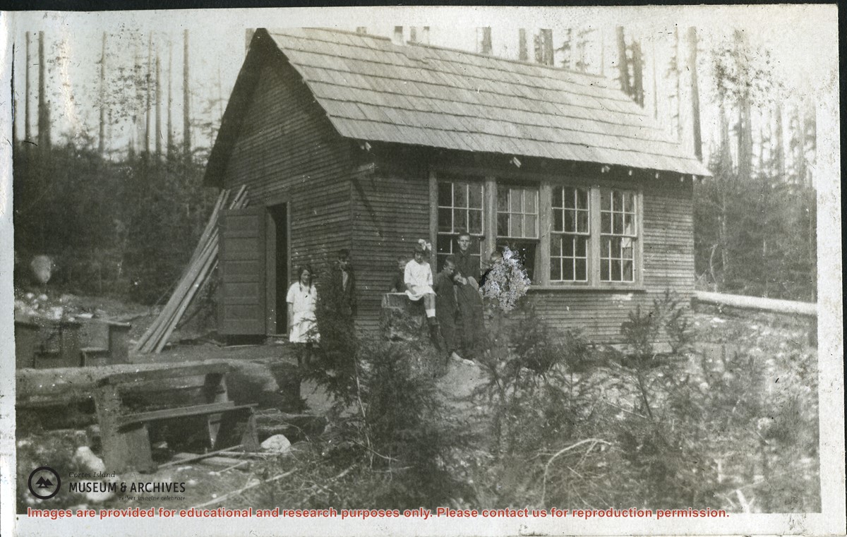
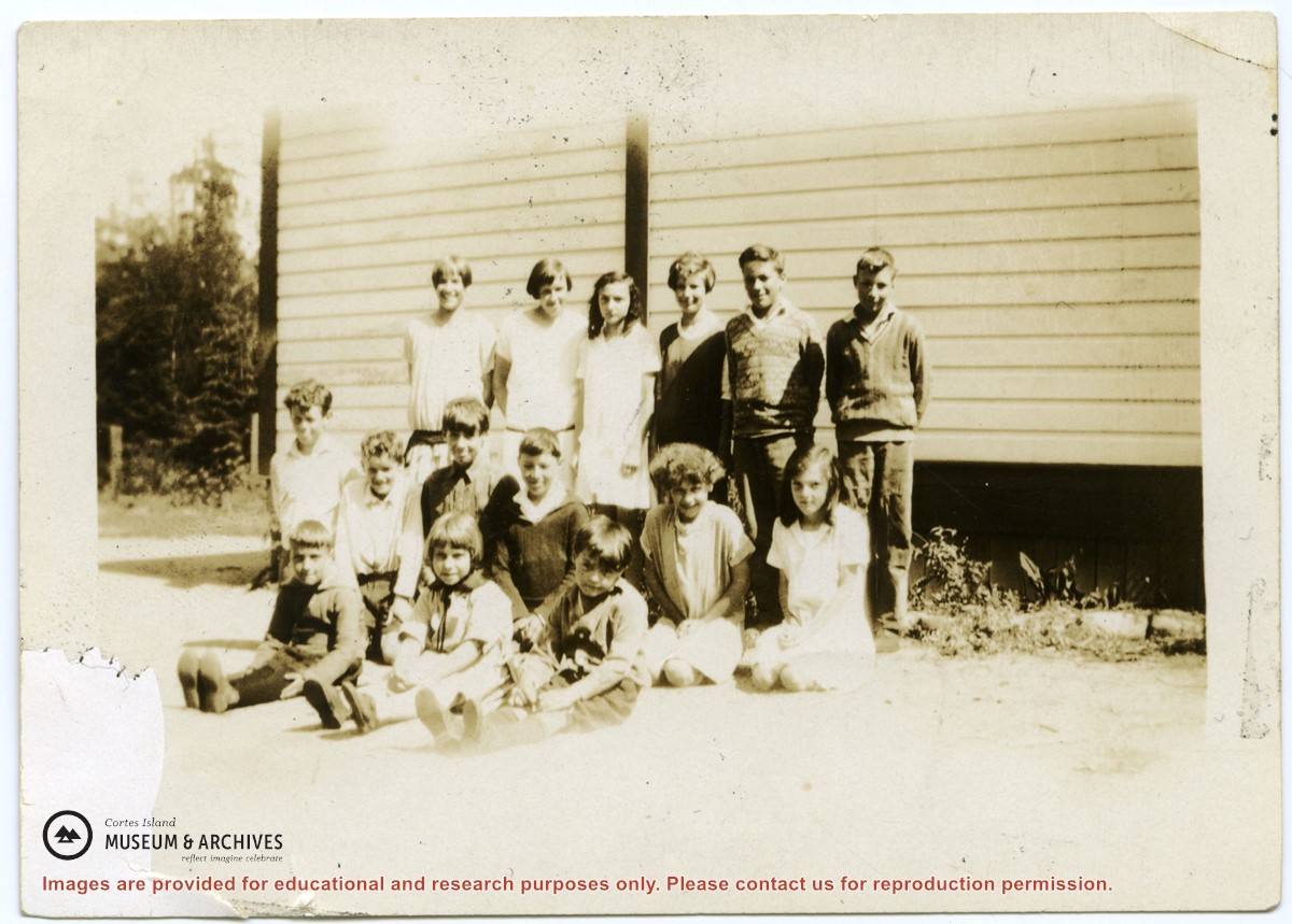
Photographs depict the pupils at the second Whaletown school standing beside the school. The photograph was taken by Evelyn Dow, who taught there from February 1928 to June 1929. This school was built in 1918 near the corner of Coulter Bay Road and Carrington Bay Road, and was used (with improvements) until 1950. The front, side and surroundings of the school are clearly shown.
Front row third from left is Marion Borden; Vernon Borden next to her fourth from left.
Top row, far right: Lorna Borden
(IDs by Terrill Marlow, Marion’s daughter, and Rob Borden, Vernon’s son).
Photographs are from an album created by Evelyn Dow and were donated to CIMAS by her niece, Sharon Thomas.
Scope and Content
Photographs depict the pupils at the second Whaletown school standing beside the school. The photograph was taken by Evelyn Dow, who taught there from February 1928 to June 1929. This school was built in 1918 near the corner of Coulter Bay Road and Carrington Bay Road, and was used (with improvements) until 1950. The front, side and surroundings of the school are clearly shown.
Front row third from left is Marion Borden; Vernon Borden next to her fourth from left.
Top row, far right: Lorna Borden
(IDs by Terrill Marlow, Marion’s daughter, and Rob Borden, Vernon’s son).
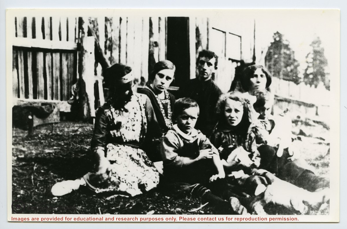
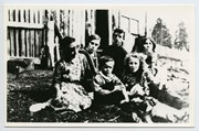
Photograph of the Squirrel Cove school, showing the entrance and side of the building in its clearing. A group of pupils is standing beside the school. Doreen Thompson has identified the pupils in 1917 as Margaret and Laurie Forrest; Harry, John and Dorothy Huck; Dave and Emmett Barrett and teacher Bob Cummings. (same as #2007.001.568)
Photograph of the Squirrel Cove school, showing the entrance and side of the building in its clearing. A group of pupils is standing beside the school. Doreen Thompson has identified the pupils in 1917 as Margaret and Laurie Forrest; Harry, John and Dorothy Huck; Dave and Emmett Barrett and teacher Bob Cummings. (same as #2007.001.568)
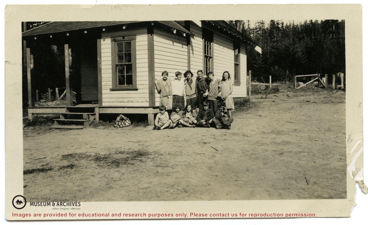
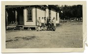
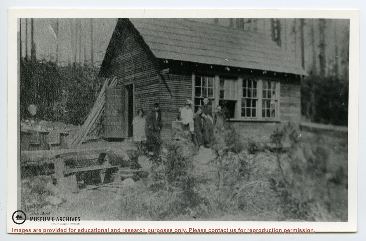
Photograph depicts the pupils at the second Whaletown school beside the corner of the school. The photograph was taken by Evelyn Dow, who taught there from February 1928 to June 1929. This school was built in 1918 near the corner of Coulter Bay Road and Carrington Bay Road, and was used (with improvements) until 1950.
Top Row: third from left, Lorna Borden; second from right, Doris Houghton-Brown
Middle row: second from left, Ken Houghton-Brown, third from left, Vernon Borden; far right, Marion Borden
Front row: far right, Claude Borden
(IDs by Terrill Marlow, Marion’s daughter, Rob Borden, Vernon’s son, and Joan Bevington, Ken Houghton-Brown's daughter).
Photograph is from an album created by Evelyn Dow and was donated to CIMAS by her niece, Sharon Thomas.
Scope and Content
Photograph depicts the pupils at the second Whaletown school beside the corner of the school. The photograph was taken by Evelyn Dow, who taught there from February 1928 to June 1929. This school was built in 1918 near the corner of Coulter Bay Road and Carrington Bay Road, and was used (with improvements) until 1950.
Top Row: third from left, Lorna Borden; second from right, Doris Houghton-Brown
Middle row: second from left, Ken Houghton-Brown, third from left, Vernon Borden; far right, Marion Borden
Front row: far right, Claude Borden
(IDs by Terrill Marlow, Marion’s daughter, Rob Borden, Vernon’s son, and Joan Bevington, Ken Houghton-Brown's daughter).
File contains text of the Memorandum of Understanding developed by Cortes Ecoforestry Society and Klahoose First Nation. Also includes twenty-nine (29) color photographic prints and eleven (11) color inkjet prints, which depict the signing of the MoU at Squirrel Cove and an Ecoforestry display at Smelt Bay. Photographs are stored in Photo Box #3.
File contains text of the Memorandum of Understanding developed by Cortes Ecoforestry Society and Klahoose First Nation. Also includes twenty-nine (29) color photographic prints and eleven (11) color inkjet prints, which depict the signing of the MoU at Squirrel Cove and an Ecoforestry display at Smelt Bay. Photographs are stored in Photo Box #3.
File contains minutes, agendas and other material relating to meetings of the Klahoose Table, attended by members of CILAC, Klahoose First Nations and government negotiators. It includes material relating to a proposed park at Carrington Bay.
File contains minutes, agendas and other material relating to meetings of the Klahoose Table, attended by members of CILAC, Klahoose First Nations and government negotiators. It includes material relating to a proposed park at Carrington Bay.