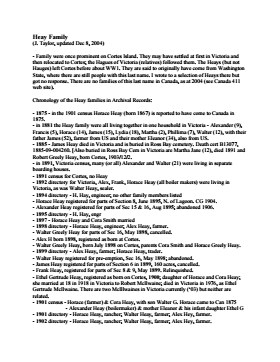
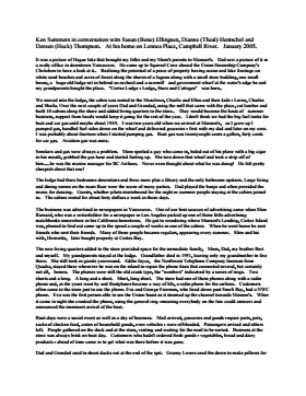
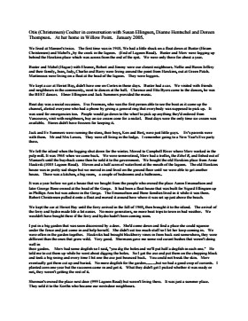
CD (2006.001.041) contains transcripts of interviews with Bert Summers, Beth (Martin) Slater, Betty Jeffery, Bill and Mary Block, Bill Guthrie, Bob Martineau, Don Levey, Frank Hayes, Fred Tomlinson, George Gardner, Heay family, Ken Summers, Otis Coulter, Pat (Fuller) Haines and Violet Herrewig. A Directory List for the CD is in folder 1-41. The transcripts may be viewed on the Archives computer, in the folder "2006.001.041 - Doreen Thompson, interview transcripts".
CD (2006.001.041) contains transcripts of interviews with Bert Summers, Beth (Martin) Slater, Betty Jeffery, Bill and Mary Block, Bill Guthrie, Bob Martineau, Don Levey, Frank Hayes, Fred Tomlinson, George Gardner, Heay family, Ken Summers, Otis Coulter, Pat (Fuller) Haines and Violet Herrewig. A Directory List for the CD is in folder 1-41. The transcripts may be viewed on the Archives computer, in the folder "2006.001.041 - Doreen Thompson, interview transcripts".
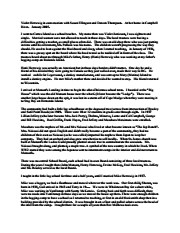
Back, L to R: Bruce Campbell, Duane Campbell, Bonnie Killian, Joan Disney, Peggy Newsham, Wendy Knudson, Kate Hathaway, Donna Norman
Front: David Blinzinger, Conductor; Bruce Ellingsen, Jack Killian, Fay Raymont, Velma Bergman, (ID), Rebecca Campbell
Back, L to R: Bruce Campbell, Duane Campbell, Bonnie Killian, Joan Disney, Peggy Newsham, Wendy Knudson, Kate Hathaway, Donna Norman
Front: David Blinzinger, Conductor; Bruce Ellingsen, Jack Killian, Fay Raymont, Velma Bergman, (ID), Rebecca Campbell
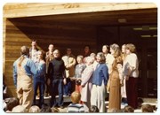
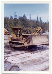
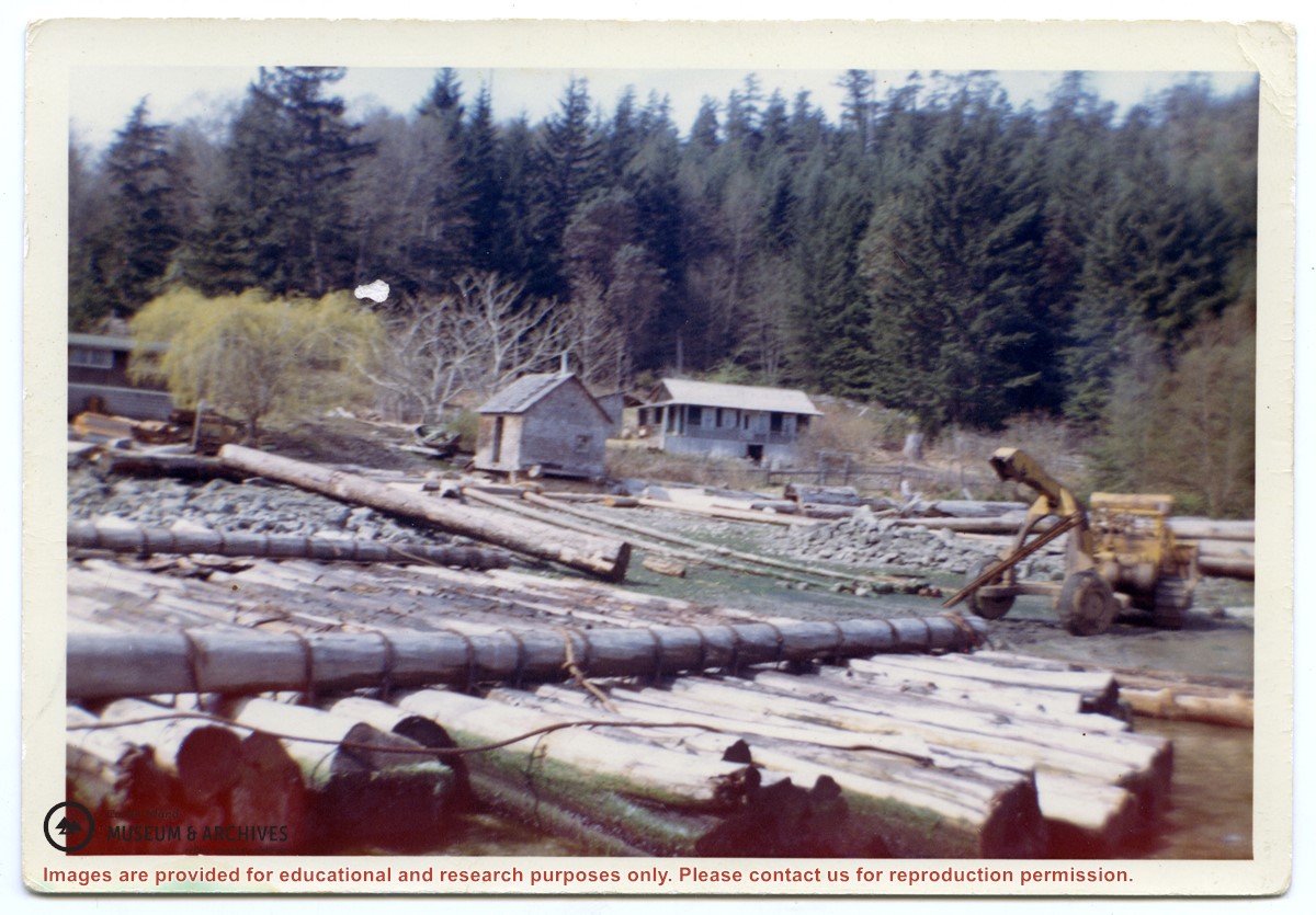
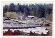
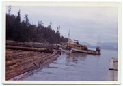
Photograph of a D8 Cat beside a log raft on the beach at Tiber Bay. A house is on the shore, along with a logging trailer and shed. Labelled on the back: "Tiber Bay. The selling out of Tooker Logging at Tiber Bay, loading of machinery." (From a group of photographs labelled "Frank Tooker photos").
Photograph of a D8 Cat beside a log raft on the beach at Tiber Bay. A house is on the shore, along with a logging trailer and shed. Labelled on the back: "Tiber Bay. The selling out of Tooker Logging at Tiber Bay, loading of machinery." (From a group of photographs labelled "Frank Tooker photos").
Photograph is labelled on the back: "Tiber Bay. The last of the Cat logging, with the tug "General Caldwell, skipper John Charltown, taking out 2 ections of fir." (From a group of photographs labelled "Frank Tooker photos").
Photograph is labelled on the back: "Tiber Bay. The last of the Cat logging, with the tug "General Caldwell, skipper John Charltown, taking out 2 ections of fir." (From a group of photographs labelled "Frank Tooker photos").
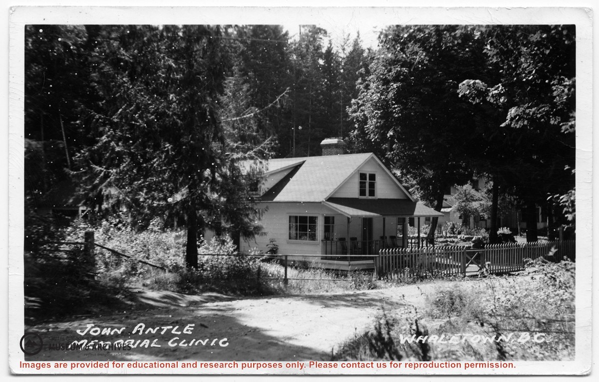
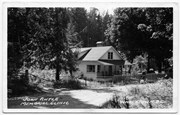
Photograph of the clinic building, with the Rectory beside it. Note the lack of telephone and electrical lines, which indicates the date is between 1950 and 1969.
Photograph of the clinic building, with the Rectory beside it. Note the lack of telephone and electrical lines, which indicates the date is between 1950 and 1969.
Series contains information on historic Crown Grants and subsequent title changes compiled by Doreen Thompson during her research for the CIMAS Windows on Whaletown exhibit in 1999. The area covered includes the northern part of Cortes Island, from just south of Gorge Harbour. Material includes maps, photocopies of original Crown Grants and other title documents, lists of subdivisions, and notes on changes of title.
Records were organized by Section or Plan number in large envelopes with a cover map and notes about the properties researched on the envelope back. They trace the ownership of parcels of land from the first grant or purchase from the Crown to 1999. Original order has been maintained.
File contains title information and photocopies of land grants and subsequent conveyances for the following:
John Williams: 1914, Crown Grant for the fractional SW 1/4 of Sec 22 and fractional NW 1/4 of Sec 22 (east of Gorge Harbour entrance)
John Williams: 1914, Crown Grant for the fractional SW 1/4 of Sec 22 and frac. NW 1/4 of Sec 18 (west of the Gorge Harbour entrance)
File contains three oversize maps which are stored in the map cabinet: Map of Section 22, Plan VIP52378, Lots A,B,C (blueprint map; 85 cm x 54 cm, 1985); map of Plan 27966 (blueprint map; 55 cm x 43 cm, 1974); photocopy of map of fractional NW 1/4 Sec 17 (55 cm x 43 cm, 1973)
(Files 3 through 7 are from the same envelope.)
File contains a photocopied section map of the northern part of Cortes Island (from just south of Gorge Harbour), coloured to indicate areas for which a Crown Grant was located and areas of ungranted Crown land which still appear to be owned by the government. Scale is 1 mile to 1 inch.
File contains a photocopied section map of the northern part of Cortes Island (from just south of Gorge Harbour), coloured to indicate areas for which a Crown Grant was located and areas of ungranted Crown land which still appear to be owned by the government. Scale is 1 mile to 1 inch.
File contains a coloured map with researched properties coloured in, and title information and photocopies of land grants and subsequent conveyances for the following:
Edward James Breeze: 1931, Crown Grant for District Lot 1373 (parts of Section 23 and Section 17, at the southeast end of Gorge Harbour by Anvil Lake)
Frank Harper: 1913, Crown Grant for the NE 96 acres of Section 23 (at the northeast end of Gorge Harbour)
(Files 3 through 7 are from the same envelope.)
File contains a map key to the areas of Sections 17, 18, 19, 22 and 34 (south of Gorge Harbour) which were researched (Information in Files 3-7).
It contains photocopies of original land grants and subsequent conveyances for the following:
Reginald James Smith: 1946, Crown Grant 165414I for fractional SE 1/4 of Sec 23, 1946 (the Thunder Road subdivision at the eastern end of Gorge Harbour).
(Files 3 through 7 are from the same envelope.)
 Slater.pdf?width=280&404=no-doc.jpg)

 Haines.pdf?width=280&404=no-doc.jpg)