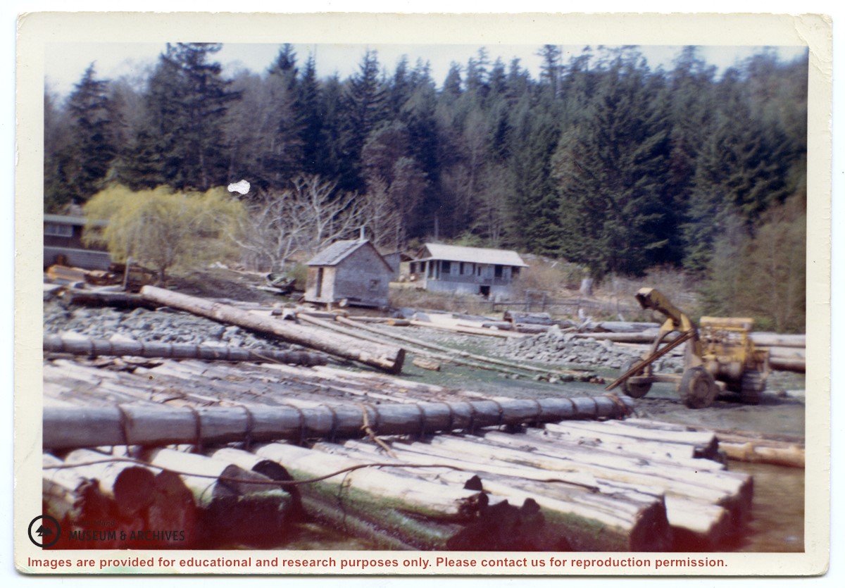
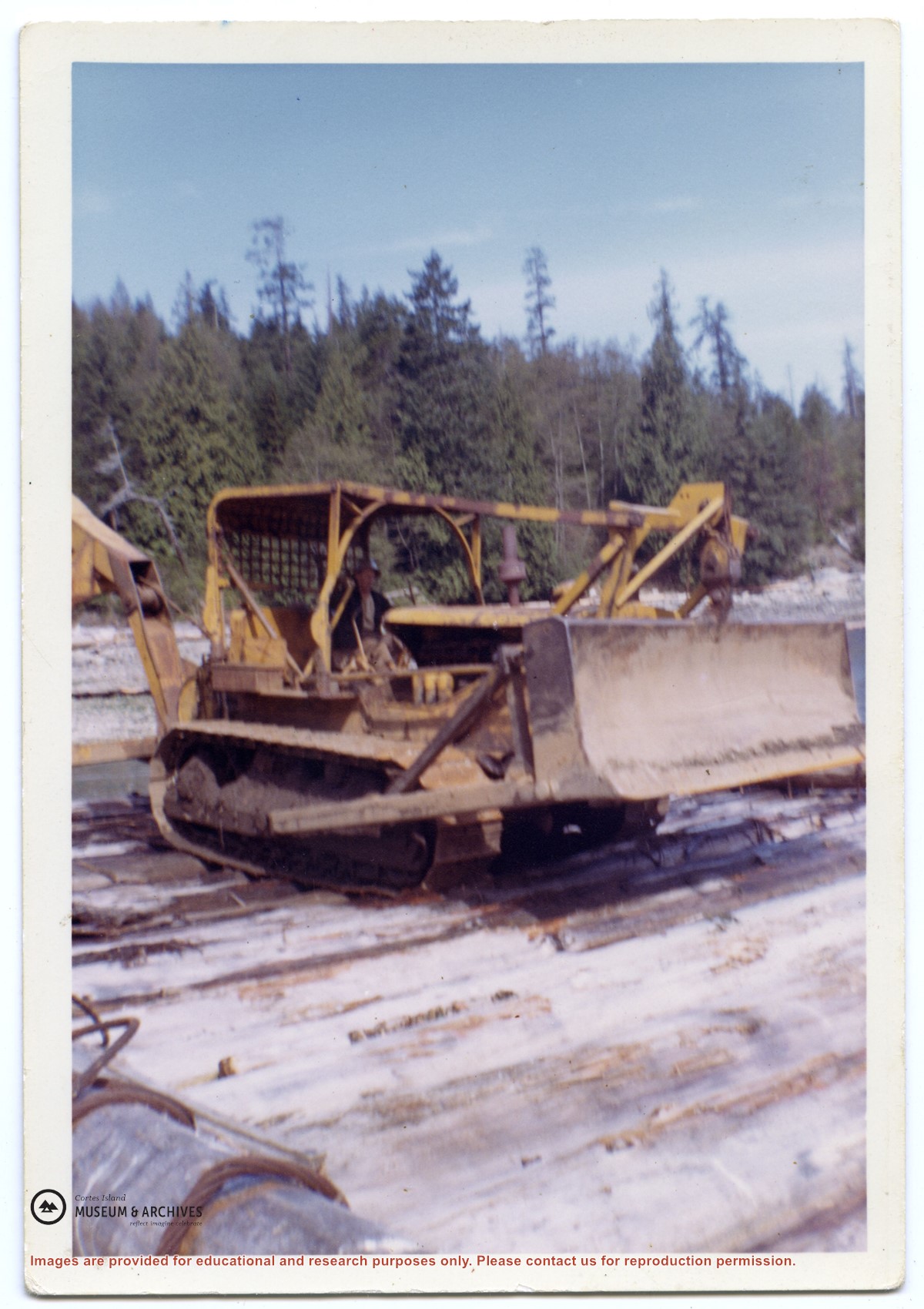
Photograph of a D8 Cat beside a log raft on the beach at Tiber Bay. A house is on the shore, along with a logging trailer and shed. Labelled on the back: "Tiber Bay. The selling out of Tooker Logging at Tiber Bay, loading of machinery." (From a group of photographs labelled "Frank Tooker photos").
Photograph of a D8 Cat beside a log raft on the beach at Tiber Bay. A house is on the shore, along with a logging trailer and shed. Labelled on the back: "Tiber Bay. The selling out of Tooker Logging at Tiber Bay, loading of machinery." (From a group of photographs labelled "Frank Tooker photos").
Emails and clippings from Tideline on history of Tiber Bay, including preemptions, Tiber/Teuber family, Manson's Landing cemetery, and the CIMAS driving tour booklet, info from early 1900s-2016.
Emails and clippings from Tideline on history of Tiber Bay, including preemptions, Tiber/Teuber family, Manson's Landing cemetery, and the CIMAS driving tour booklet, info from early 1900s-2016.
Genealogical info on Tiber/Teuber family, results from 1800s-1985. Photocopies from CIMAS photo album with photographs, descriptions, and list of pre-emptions, 1892-1950. Scanned clippings featuring August Teuber, 1925. Excerpts from: In Paradise and On the West Coast by Barbara Ann Lambert; Destination Cortez by June Cameron; and Desolation Sound by Heather Harbord. "Cortes Island Back Then" by Gertie Lambert. Emails regarding Tiber/Teuber family research, 2007-2014
Genealogical info on Tiber/Teuber family, results from 1800s-1985. Photocopies from CIMAS photo album with photographs, descriptions, and list of pre-emptions, 1892-1950. Scanned clippings featuring August Teuber, 1925. Excerpts from: In Paradise and On the West Coast by Barbara Ann Lambert; Destination Cortez by June Cameron; and Desolation Sound by Heather Harbord. "Cortes Island Back Then" by Gertie Lambert. Emails regarding Tiber/Teuber family research, 2007-2014
File contains a key map and list for the areas researched and information on the following:
George Herbert Wailes: 1920, Crown Grant for fractional SW 1/4 of Sec. 48; 48 acres for $217; with a tax sale notice, 1939
Ina Vernon Munro: 1920, Crown Grant for NE 1/4 of Sec. 37; 161 acres; includes a sale to Hawkins and a forfeit in 1939
Allan Olmsted: 1939, Crown Grant for SW 1/4 of Sec. 37
Ira Furry: 1911, Crown Grant for W 1/2 of SE 1/4 of Sec. 33
Walter Malcolm: 1919, Crown Grant for fractional SW 1/4 of Sec. 36
Frank Leslie Tooker: 1926, Crown Grant for N 1/2 of Sec. 36, 124 acres
Ira Furry: 1897, Crown Grant for SE 1/4 of Sec 36; 160 acres for $160.00.
Donald McDonald: 1926, Crown Grant for fractional NW 1/2 of Sec. 37; 144 acres for $1.00
Info on Carrington Bay history and early settler homesteaders from late 1800s onward; scans from Whaletown to 1930 album; scan of location for Department of Energy, Mines and Resources, 1945; park brochure; clippings about Carrington from 1982-2014; excerpt from interview with Clarence and Etta Byers, 2001; notes from exhibit curation (labels, photo captions, etc); excerpts rom June Cameron's Destination Cortez; topographic map of Green Mountain; emails about exhibit; printed photographs for exhibit. Keywords: drowing, Island Timberland, Coulter Bay, stream keepers
Info on Carrington Bay history and early settler homesteaders from late 1800s onward; scans from Whaletown to 1930 album; scan of location for Department of Energy, Mines and Resources, 1945; park brochure; clippings about Carrington from 1982-2014; excerpt from interview with Clarence and Etta Byers, 2001; notes from exhibit curation (labels, photo captions, etc); excerpts rom June Cameron's Destination Cortez; topographic map of Green Mountain; emails about exhibit; printed photographs for exhibit. Keywords: drowing, Island Timberland, Coulter Bay, stream keepers
Writing, emails and excerpts with info on early homesteaders, early postmasters, the first post box in Cortes Bay, Frabjous Bay/Frabjous Day, The Columbia Coast Mission, and the Rendezvous. Map of lots with some names of early homesteaders near Cortes Bay. Old postcard of Cortes Bay
Writing, emails and excerpts with info on early homesteaders, early postmasters, the first post box in Cortes Bay, Frabjous Bay/Frabjous Day, The Columbia Coast Mission, and the Rendezvous. Map of lots with some names of early homesteaders near Cortes Bay. Old postcard of Cortes Bay
Written info on Carrington Bay and Coulter Bay with info from late 1800s; info from Doris (Houghton-Brown) Henderson on Cortes Island early history, late 1920s. Ian and Mary McMillan's island in Coulter Bay listing, early 1950s. Info about Rendezvous Rock in Coulter Bay, 1953, from CIMAS photo albums. Excerpt from The Columbia is Coming!, Doris Anderson, 1982. Clippings from WNE with info on Coulter Bay, 1982-1992. Typed transcript of written letter from Mary McMillen to Doreen Thompson, undated.
Written info on Carrington Bay and Coulter Bay with info from late 1800s; info from Doris (Houghton-Brown) Henderson on Cortes Island early history, late 1920s. Ian and Mary McMillan's island in Coulter Bay listing, early 1950s. Info about Rendezvous Rock in Coulter Bay, 1953, from CIMAS photo albums. Excerpt from The Columbia is Coming!, Doris Anderson, 1982. Clippings from WNE with info on Coulter Bay, 1982-1992. Typed transcript of written letter from Mary McMillen to Doreen Thompson, undated.
Scanned photograph of Baron & Nellie Jeffery home at Smelt Bay, 1982. Smelt Bay Master Plan, Province of British Columbia, Ministry of Environment and Parks, 1987. Full issue of The Cottage Magazine, article featuring Smelt Bay midden sites, 1997. Excerpt from Seven Knot Summers, Beth Hill. Post cards and greeting cards featuring Smelt Bay, undated.
Scanned photograph of Baron & Nellie Jeffery home at Smelt Bay, 1982. Smelt Bay Master Plan, Province of British Columbia, Ministry of Environment and Parks, 1987. Full issue of The Cottage Magazine, article featuring Smelt Bay midden sites, 1997. Excerpt from Seven Knot Summers, Beth Hill. Post cards and greeting cards featuring Smelt Bay, undated.
File contains photocopies of original Crown Grants, subsequent title changes and maps for:
To Joseph Gregson: 1926, Crown Grant for fractional W 1/2 of Lot 899 and Lot 901 (between Coulter and Carrington Bays), with a water easement for Wailes
To John Nugent McIllree: 1957, Crown Grant of mineral rights to lots at Coulter Bay surveyed as the "Arrow" and "Bullseye" mineral claims
To Hilda Peterson: 1919, Crown Grant for Lot 878, Carrington Bay, 55 acres
(Files 12 through 16 are from the same envelope.)
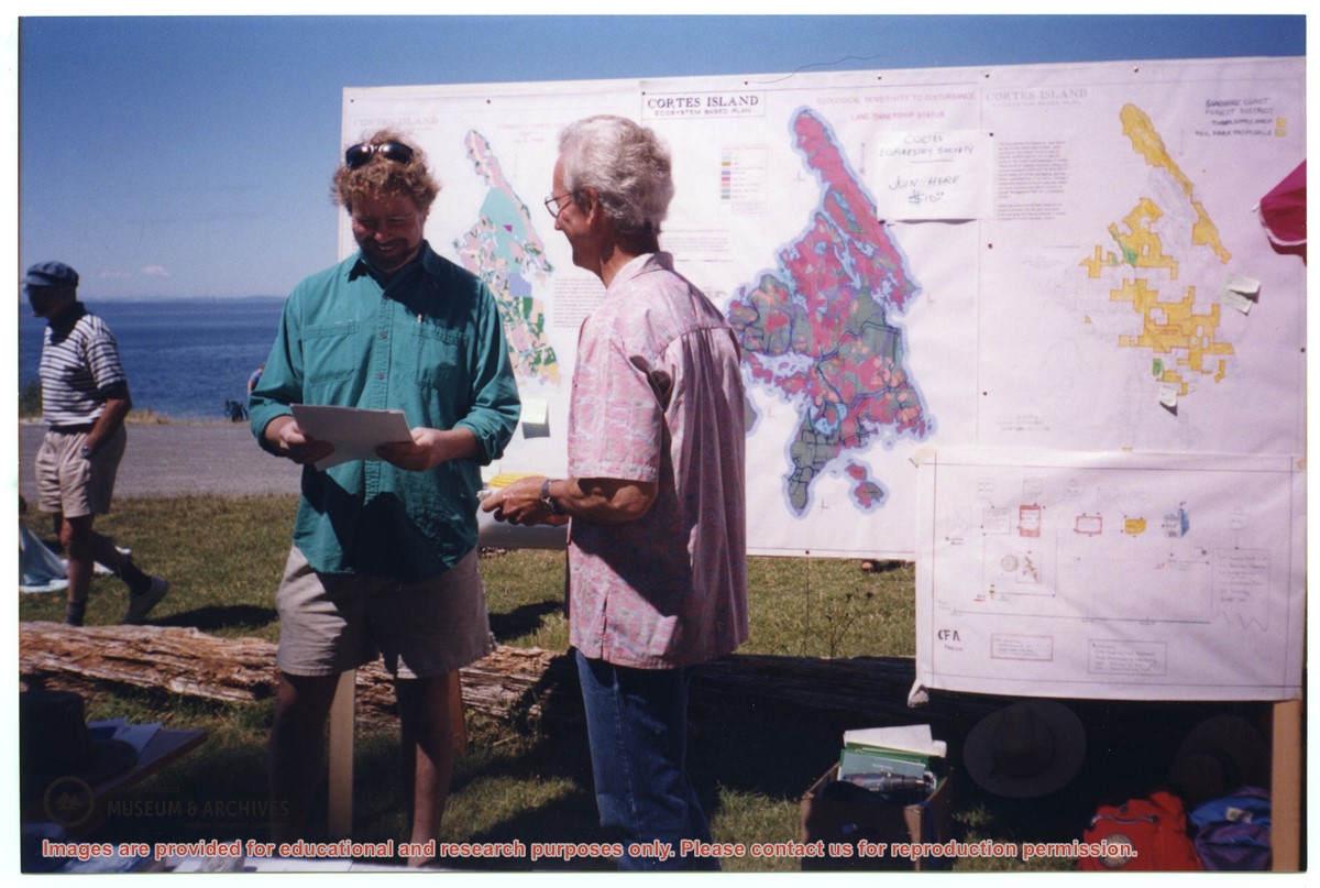
File contains materials related to Raven Forest Products Ltd's proposal for logging in Section 38 on Cortes Island, including maps, correspondence, meeting transcripts, and newsletters.
File contains materials related to Raven Forest Products Ltd's proposal for logging in Section 38 on Cortes Island, including maps, correspondence, meeting transcripts, and newsletters.
Series consists of documents pertaining to a lawsuit between Chief Raymond Noble of Klahoose First Nation (suing on behalf of all members of the KFN) and the following plaintiffs: Cortes Ecoforestry Society, Linnaea Farm Society, certain members of the Klahoose First Nation, and members of the aforementioned organizations. The lawsuit concerned an alleged blockage, which barred access to Woodlot 009, thus interfering with Klahoose logging operations.
Series consists of documents pertaining to a lawsuit between Chief Raymond Noble of Klahoose First Nation (suing on behalf of all members of the KFN) and the following plaintiffs: Cortes Ecoforestry Society, Linnaea Farm Society, certain members of the Klahoose First Nation, and members of the aforementioned organizations. The lawsuit concerned an alleged blockage, which barred access to Woodlot 009, thus interfering with Klahoose logging operations.
File contains an assessment of the boat launch ramp at Mansons Landing Provincial Park; a bound copy of the Mansons Landing Park Master Plan; and material on the proposed Hague Lake Park including correspondence, a map and a copy of the Whaletown National Enquirer with the steam donkey story.
File contains an assessment of the boat launch ramp at Mansons Landing Provincial Park; a bound copy of the Mansons Landing Park Master Plan; and material on the proposed Hague Lake Park including correspondence, a map and a copy of the Whaletown National Enquirer with the steam donkey story.
File contains a page of notes, and photocopies of a tax sale notice (1938) and list of properties forfeited for non-payment of taxes, Crown Grants and other title information for the following:
William Walter James: 1926, Crown Grant for NW 1/4 of Sec. 38; 156 acres for $1.00; forfeited to Crown in 1939
Tom Albinson: 1919, Crown Grant for Lot 867; forfeited in 1927
Sadie McMurray: 1917, NE 1/4 of Sec. 39; 160 acres for $160
Peter Police: 1925, fractional NW 1/4 of Sec. 39; 103 acres for $1.00
(Files 12 through 16 are from the same envelope.)