File contains information for Crown Grants and subsequent title changes for:
William John Sheepwash: 1916, Certificate of Title for District Lot 905 (on Von Donop Creek), 9.6 acres
William Black, Walter Black, William Reid Black and Marjory Black: 1930, Crown Grant for District Lot 1168, ca. 68 acres
William John Sheepwash: 1916, Crown Grant for fractional NE 1/4 of Sec. 45; 153 acres for $153.00
John Bruce Manson: 1942, Crown Grant for District Lot 903; 126 acres for $315.00
File also contains a photocopied map of Lot 903 and the NE 1/4 of Sec. 45, and a Subdivision Plan of Lot 1168 and part of blocks A & B, Lot 747 (1982; in the Map folder).
(Files 12 through 16 are from the same envelope.)
Clippings with info on floathouses, the hermit of Von Donop Channel, the landslide at Spences Bridge, Von Donop Marine Park, Klahoose First Nation, and Doreen Thompson, 1920-2017, and clippings from WNE, 1987-1989. Transcript with info on the Ellingsens in Von Donop Creek, 1946-1950, from interview with May, Elmer, Andy, and Bruce Ellginsen, 2001. Info on logging in Von Donop Creek, 1920s-1960, from a logging meeting in 2001. Info from Von Donop Creek Research and Display for CIMAS, 2001. An envelope with info from Bev Mathews, donated in 2013.
Clippings with info on floathouses, the hermit of Von Donop Channel, the landslide at Spences Bridge, Von Donop Marine Park, Klahoose First Nation, and Doreen Thompson, 1920-2017, and clippings from WNE, 1987-1989. Transcript with info on the Ellingsens in Von Donop Creek, 1946-1950, from interview with May, Elmer, Andy, and Bruce Ellginsen, 2001. Info on logging in Von Donop Creek, 1920s-1960, from a logging meeting in 2001. Info from Von Donop Creek Research and Display for CIMAS, 2001. An envelope with info from Bev Mathews, donated in 2013.
File contains a key map which was pasted on the front of the envelope indicating the areas researched for Files 12-16; notes on the titles; photocopies of Crown Grants and subsequent title information for:
BC Buildings Corp: 1982, Crown Grant for Block A of SW 1/4 of Sec. 25 (Highways Maintenance Yard)
District Lot 871 (40 acres between Carrington and Coulter Bays): to James Frederick McManus, 1919
To Ernest Henry Vaughn: 1922, Crown Grant for NE 1/4 and NW 1/4 of NE 1/4 of Sec. 24; SE 1/4 of SW 1/4 and SW 1/4 of SE 1/4 of Sec 31
Herbert Proctor: 1928 for fractional SW 1/4 of Sec. 41, bordering Tork Reserve; 159 acres for $159.00 (orig. Crown Grant to Herbert Proctor in 1922)
To William Cowan: 1937, E 1/2 of SE 1/4 of Sec. 26, 89 acres
(Files 12 through 16 are from the same envelope.)
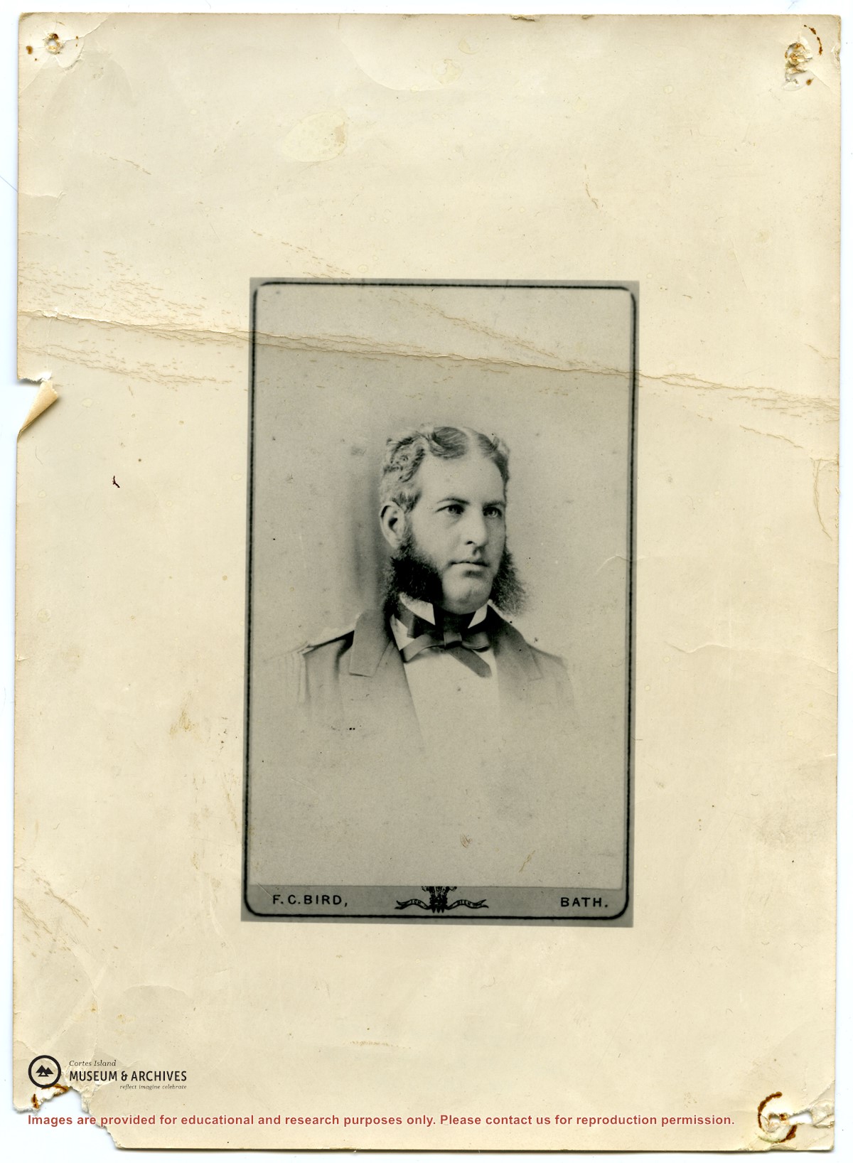
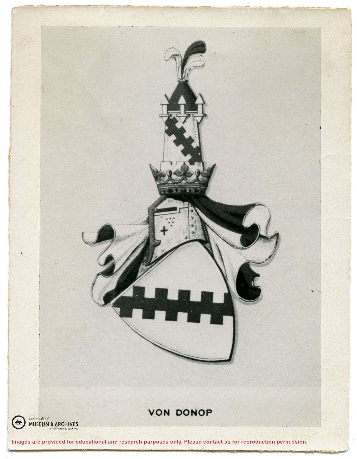
Series consists of correspondence from Theodore Von Donop to Jimmy Layton and information, photographs and ephemera relating to Victor Von Donop, after whom Von Donop Inlet was named. The two photographs that were part of this material (2003.002.393-Portrait of Victor Von Donop and 2003.002.394-Coat of arms of Von Donop family) are described in Series 1 and stored in the Photographs box with the other photographs in the Weiler fonds.)
Material was collected by Jimmy Layton, who had a homestead at the head of Von Donop Inlet; he gave it to Otto Weiler.
Scope and Content
Series consists of correspondence from Theodore Von Donop to Jimmy Layton and information, photographs and ephemera relating to Victor Von Donop, after whom Von Donop Inlet was named. The two photographs that were part of this material (2003.002.393-Portrait of Victor Von Donop and 2003.002.394-Coat of arms of Von Donop family) are described in Series 1 and stored in the Photographs box with the other photographs in the Weiler fonds.)
Series contains information on historic Crown Grants and subsequent title changes compiled by Doreen Thompson during her research for the CIMAS Windows on Whaletown exhibit in 1999. The area covered includes the northern part of Cortes Island, from just south of Gorge Harbour. Material includes maps, photocopies of original Crown Grants and other title documents, lists of subdivisions, and notes on changes of title.
Records were organized by Section or Plan number in large envelopes with a cover map and notes about the properties researched on the envelope back. They trace the ownership of parcels of land from the first grant or purchase from the Crown to 1999. Original order has been maintained.
File contains information for the following properties:
Frederick James Smith: 1921, Crown Grant for SE 1/4 of Sec. 33; 160 acres for $1.00
Charles Allen: 1912, Crown Grant for SW 1/4 of Sec. 33; 160 acres for $160.
George Robson: 1907, Crown Grant for NW 1/4 of Sec. 21; $247.00 for 142 acres.
(Files 17 through 19 are from the same envelope.)
File contains title information and photocopies of land grants and subsequent conveyances for the following:
John Williams: 1914, Crown Grant for the fractional SW 1/4 of Sec 22 and fractional NW 1/4 of Sec 22 (east of Gorge Harbour entrance)
John Williams: 1914, Crown Grant for the fractional SW 1/4 of Sec 22 and frac. NW 1/4 of Sec 18 (west of the Gorge Harbour entrance)
File contains three oversize maps which are stored in the map cabinet: Map of Section 22, Plan VIP52378, Lots A,B,C (blueprint map; 85 cm x 54 cm, 1985); map of Plan 27966 (blueprint map; 55 cm x 43 cm, 1974); photocopy of map of fractional NW 1/4 Sec 17 (55 cm x 43 cm, 1973)
(Files 3 through 7 are from the same envelope.)
File contains a photocopy of Crown Grant and documentation of subsequent changes in title for:
William Barrett Lennard: 1928, Crown Grant for the SE and SW 1/4s of Section 23 (on the SE shore of Gorge Harbour)
(Files 3 through 7 are from the same envelope.)
File contains a photocopy of Crown Grant and documentation of subsequent changes in title for:
William Barrett Lennard: 1928, Crown Grant for the SE and SW 1/4s of Section 23 (on the SE shore of Gorge Harbour)
(Files 3 through 7 are from the same envelope.)
File contains a photocopy of Crown Grant and documentation of subsequent changes in title for:
Eliza Breeze: 1920, Crown Grant for Fractional NW 1/4 of Section 18 (east of the entrance to Gorge Harbour)
(Files 3 through 7 are from the same envelope.)
File contains a photocopy of Crown Grant and documentation of subsequent changes in title for:
Eliza Breeze: 1920, Crown Grant for Fractional NW 1/4 of Section 18 (east of the entrance to Gorge Harbour)
(Files 3 through 7 are from the same envelope.)
File contains a section map showing properties southeast of Gorge Harbour and title information on the property, later owned by Gilean Douglas, and known as Channel Rock.
To John Pool: 1930, Crown Grant of the W 1/2 of the SE 1/4 of Sec. 21 and fractional SW 1/4 of Sec. 21 and Crown Grant fo the fractional E 1/2 of fractional SE 1/4 of Sec. 21
File contains information for the following properties:
E. H. Vaughn: 1893, Crown Grant for fractional N 1/2 of Sec. 22; 90 acres for $90.00.
James P. Allen: 1913, Crown Grant for NW 34 acres of Sec. 23; $170.00
Bernard Robinson Allen: 1919, Crown Grant for SW 1/4 of Sec. 23, 159 acres
Charles Allen: 1912, Crown Grant for SW 1/4 of Sec. 33; 160 acres for $160.00
Harold Marshall Wood: Crown Grant for E 1/2 of NE 1/4 of Sec. 46 (east of Carrington Bay); 81 acres for $1.00.
File contains the following maps, stored in the Map Cabinet:
Subdivision Plan of parcel C & E, NW 1/4 of Sec. 21, 1976
Subdivision of the fractional NE 1/4 of Sec 21, 1966; with names of property owners penciled in
Subdivision Plan of Parcel C and part of Parcel E of fractional NE 1/4 of Sec. 21, 1975
Subdivision Plan of fractional NE 1/4 of Sec. 21 and W 1/2 of SW 1/4 of Sec. 34
(Files 17 through 19 are from the same envelope.)
File contains a key map and list for the areas researched and information on the following:
George Herbert Wailes: 1920, Crown Grant for fractional SW 1/4 of Sec. 48; 48 acres for $217; with a tax sale notice, 1939
Ina Vernon Munro: 1920, Crown Grant for NE 1/4 of Sec. 37; 161 acres; includes a sale to Hawkins and a forfeit in 1939
Allan Olmsted: 1939, Crown Grant for SW 1/4 of Sec. 37
Ira Furry: 1911, Crown Grant for W 1/2 of SE 1/4 of Sec. 33
Walter Malcolm: 1919, Crown Grant for fractional SW 1/4 of Sec. 36
Frank Leslie Tooker: 1926, Crown Grant for N 1/2 of Sec. 36, 124 acres
Ira Furry: 1897, Crown Grant for SE 1/4 of Sec 36; 160 acres for $160.00.
Donald McDonald: 1926, Crown Grant for fractional NW 1/2 of Sec. 37; 144 acres for $1.00