File contains a page of notes, and photocopies of a tax sale notice (1938) and list of properties forfeited for non-payment of taxes, Crown Grants and other title information for the following:
William Walter James: 1926, Crown Grant for NW 1/4 of Sec. 38; 156 acres for $1.00; forfeited to Crown in 1939
Tom Albinson: 1919, Crown Grant for Lot 867; forfeited in 1927
Sadie McMurray: 1917, NE 1/4 of Sec. 39; 160 acres for $160
Peter Police: 1925, fractional NW 1/4 of Sec. 39; 103 acres for $1.00
(Files 12 through 16 are from the same envelope.)
File contains a key map which was pasted on the front of the envelope indicating the areas researched for Files 12-16; notes on the titles; photocopies of Crown Grants and subsequent title information for:
BC Buildings Corp: 1982, Crown Grant for Block A of SW 1/4 of Sec. 25 (Highways Maintenance Yard)
District Lot 871 (40 acres between Carrington and Coulter Bays): to James Frederick McManus, 1919
To Ernest Henry Vaughn: 1922, Crown Grant for NE 1/4 and NW 1/4 of NE 1/4 of Sec. 24; SE 1/4 of SW 1/4 and SW 1/4 of SE 1/4 of Sec 31
Herbert Proctor: 1928 for fractional SW 1/4 of Sec. 41, bordering Tork Reserve; 159 acres for $159.00 (orig. Crown Grant to Herbert Proctor in 1922)
To William Cowan: 1937, E 1/2 of SE 1/4 of Sec. 26, 89 acres
(Files 12 through 16 are from the same envelope.)
Fonds consists of the records of the Cortes Island Ratepayers Association, an organization of the property owners and residents of Cortes Island from 1963 to 1984. They include administrative documents such as the constitution and membership lists, minutes of CIRA meetings, annual reports, newsletters to members, correspondence and materials related to the provision of services, land use planning and other issues of island concern.
The fonds is composed of the following series: Administrative Documents; Minutes; Financial; Newsletters and Notices; Correspondence; Subject; Community Planning and Land Use (Advisory Planning Commission); Clippings; and Maps and Plans.
The Cortes Island Ratepayers Association (CIRA) was an association of property owners and residents formed in 1963 to "further the development of the island and to have a representative body in dealing with the Provincial government."
The first activity initiated by CIRA was to lobby the provincial government for the provision of electricity and ferry service to Cortes Island. Their efforts met with success. Electricity was brought to the island in 1970 and ferry service from Quadra Island to Cortes Island began in 1969. CIRA also became an important forum for the discussion of other important services on Cortes Island, including roads, fire protection, garbage disposal, water quality, rural mail delivery and library facilities.
As a result of CIRA's efforts to bring electricity to Cortes Island, in 1967 the Minister of Municipal Affairs, Dan Campbell, designated Cortes Island a Local Improvement District. This made Cortes Island into a legal entity for the purpose of negotiating with the province for electrical power. In that same year, Minister Campbell invited CIRA to participate in discussions and committee work on the formation of a regional district level of government.
In 1968, Cortes Island was designated 'Electoral Area I' in the Regional District of Comox-Strathcona (RDCS) with an elected director. Under this system, a Regional Director is elected who in turn sits on the Board of the RDCS. Each Regional Director appoints an Advisory Planning Commission (APC), a committee of island residents who advise the Director on matters of island concern. In 1968, CIRA determined that the elected members of the executive of CIRA would form the APC for Cortes Island. This arrangement lasted until the dissolution of CIRA in 1984. The first zoning by-law was completed in 1970 and an Official Settlement Plan and zoning by-law in 1979.
In 1982, CIRA initiated a court case against Raven Lumber for non-compliance with the Cortes Island Official Settlement Plan and zoning by-law. CIRA won the case upon appeal, but in 1984 an Order in Council allowed Raven Lumber to proceed with their development. The court case had absorbed a great deal of CIRA energy and fund raising effort over a four year period. At the General Meeting in November, 1984 there were no candidates willing to stand for the executive. CIRA was declared inactive at that meeting and was never reactivated.
Custodial History
During the term of the last president of CIRA, the records were kept in the Gorge Harbour Community Hall on Cortes Island. After the dissolution of the CIRA in 1984, the records continued to be stored in the hall. The records were transferred to the Cortes Island Museum and Archives by the Whaletown Community Club (owner of the hall) in 2000.
Scope and Content
Fonds consists of the records of the Cortes Island Ratepayers Association, an organization of the property owners and residents of Cortes Island from 1963 to 1984. They include administrative documents such as the constitution and membership lists, minutes of CIRA meetings, annual reports, newsletters to members, correspondence and materials related to the provision of services, land use planning and other issues of island concern.
The fonds is composed of the following series: Administrative Documents; Minutes; Financial; Newsletters and Notices; Correspondence; Subject; Community Planning and Land Use (Advisory Planning Commission); Clippings; and Maps and Plans.
Regional Director of Electoral Area I (Cortes Island) fonds
Gilean Douglas fonds
Finding Aid
File list available
Arrangement
Materials were received in their original file folders, however the files were not in any discernible order. In the absence of original order, materials were arranged by function and subject at the series level and chronologically within series.
Series consists of material generated and collected by Douglas during her term on the Comox-Strathcona Regional Board. Douglas served as Alternate Director from 1968 to 1973, and as Director from 1973 to 1978. During this time, island residents were actively involved in the formulation of Cortes' first Official Settlement Plan and Zoning By-law. Series includes reports, correspondence, notes, copies of studies, Regional District by-laws and drafts of by-laws, including the Official Settlement Plan. It also contains materials on community organizations generated after her term which she collected because of a continuing interest in local government and community planning, and because, as a former Director, she was often consulted on island issues.
Series consists of material generated and collected by Douglas during her term on the Comox-Strathcona Regional Board. Douglas served as Alternate Director from 1968 to 1973, and as Director from 1973 to 1978. During this time, island residents were actively involved in the formulation of Cortes' first Official Settlement Plan and Zoning By-law. Series includes reports, correspondence, notes, copies of studies, Regional District by-laws and drafts of by-laws, including the Official Settlement Plan. It also contains materials on community organizations generated after her term which she collected because of a continuing interest in local government and community planning, and because, as a former Director, she was often consulted on island issues.
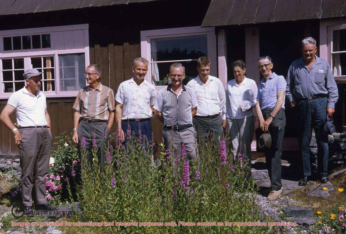
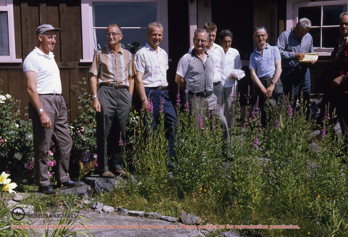
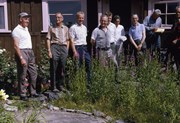
Photo of same group of people as #1999.001.2472, except with Ken Slater at far right
(L to R): Wilf Freeman, (ID), Elmer Ellingsen, Dan Campbell, Bud Guthrie, Nesta Slater, George Griffin, Harry Huck, Ken Slater
Photo of same group of people as #1999.001.2472, except with Ken Slater at far right
(L to R): Wilf Freeman, (ID), Elmer Ellingsen, Dan Campbell, Bud Guthrie, Nesta Slater, George Griffin, Harry Huck, Ken Slater
File contains a cerlox-bound proposal to acquire MacMillan Bloedel lands on Cortes Island, with supporting documents from Klahoose First Nation and The Land Conservancy of BC.
File contains a cerlox-bound proposal to acquire MacMillan Bloedel lands on Cortes Island, with supporting documents from Klahoose First Nation and The Land Conservancy of BC.
File contains information for the following properties:
E. H. Vaughn: 1893, Crown Grant for fractional N 1/2 of Sec. 22; 90 acres for $90.00.
James P. Allen: 1913, Crown Grant for NW 34 acres of Sec. 23; $170.00
Bernard Robinson Allen: 1919, Crown Grant for SW 1/4 of Sec. 23, 159 acres
Charles Allen: 1912, Crown Grant for SW 1/4 of Sec. 33; 160 acres for $160.00
Harold Marshall Wood: Crown Grant for E 1/2 of NE 1/4 of Sec. 46 (east of Carrington Bay); 81 acres for $1.00.
File contains the following maps, stored in the Map Cabinet:
Subdivision Plan of parcel C & E, NW 1/4 of Sec. 21, 1976
Subdivision of the fractional NE 1/4 of Sec 21, 1966; with names of property owners penciled in
Subdivision Plan of Parcel C and part of Parcel E of fractional NE 1/4 of Sec. 21, 1975
Subdivision Plan of fractional NE 1/4 of Sec. 21 and W 1/2 of SW 1/4 of Sec. 34
(Files 17 through 19 are from the same envelope.)