Series consists of correspondence from Theodore Von Donop to Jimmy Layton and information, photographs and ephemera relating to Victor Von Donop, after whom Von Donop Inlet was named. The two photographs that were part of this material (2003.002.393-Portrait of Victor Von Donop and 2003.002.394-Coat of arms of Von Donop family) are described in Series 1 and stored in the Photographs box with the other photographs in the Weiler fonds.)
Material was collected by Jimmy Layton, who had a homestead at the head of Von Donop Inlet; he gave it to Otto Weiler.
Scope and Content
Series consists of correspondence from Theodore Von Donop to Jimmy Layton and information, photographs and ephemera relating to Victor Von Donop, after whom Von Donop Inlet was named. The two photographs that were part of this material (2003.002.393-Portrait of Victor Von Donop and 2003.002.394-Coat of arms of Von Donop family) are described in Series 1 and stored in the Photographs box with the other photographs in the Weiler fonds.)
Binder contains interviews, stories and pictures. Binder contains interviews, stories and pictures. It was created in 2001 as part of the exhibit "The Von Donop Creek Story - 1920-1960", curated and mounted by Doreen Thompson.
Binder contains interviews, stories and pictures. Binder contains interviews, stories and pictures. It was created in 2001 as part of the exhibit "The Von Donop Creek Story - 1920-1960", curated and mounted by Doreen Thompson.
Binder contains interviews, stories and pictures. Binder contains interviews, stories and pictures. It was created in 2001 as part of the exhibit "The Von Donop Creek Story - 1920-1960", curated and mounted by Doreen Thompson.
Binder contains interviews, stories and pictures. Binder contains interviews, stories and pictures. It was created in 2001 as part of the exhibit "The Von Donop Creek Story - 1920-1960", curated and mounted by Doreen Thompson.
Binder contains interviews, stories and pictures. It was created in 2001 as part of the exhibit "The Von Donop Creek Story - 1920-1960", curated and mounted by Doreen Thompson. Binder contains interviews, stories and pictures.
Binder contains interviews, stories and pictures. It was created in 2001 as part of the exhibit "The Von Donop Creek Story - 1920-1960", curated and mounted by Doreen Thompson. Binder contains interviews, stories and pictures.
Series contains five maps:(1) Southern half of Cortes Island, BC Ministry of the Environment, 1975, 24" by 36"; (2) Marina Island and part of Gorge Harbour, BC Ministry of the Environment, 1975, 24" by 36"; (3)Cortes Island (West Half), surveyor's map, 1975, 18" by 44"; (4)Cortes Island (East Half), surveyor's map, 1975, 18" by 44"; (5) Cortes Island Coastal Resource Policies, Schedule B, 1987, 14" by 24", scale 1/50,000 - an RDCS planning map showing uses of the foreshore and water surrounding Cortes, with foreshore lease data to 1987.
Series contains five maps:(1) Southern half of Cortes Island, BC Ministry of the Environment, 1975, 24" by 36"; (2) Marina Island and part of Gorge Harbour, BC Ministry of the Environment, 1975, 24" by 36"; (3)Cortes Island (West Half), surveyor's map, 1975, 18" by 44"; (4)Cortes Island (East Half), surveyor's map, 1975, 18" by 44"; (5) Cortes Island Coastal Resource Policies, Schedule B, 1987, 14" by 24", scale 1/50,000 - an RDCS planning map showing uses of the foreshore and water surrounding Cortes, with foreshore lease data to 1987.
File contains maps of Bute Inlet (1970), Cortes Island/Read Island and surrounding area (ca. 1950), Powell River (1968) and Cortes Island zoning maps (Jan 1974).
File contains maps of Bute Inlet (1970), Cortes Island/Read Island and surrounding area (ca. 1950), Powell River (1968) and Cortes Island zoning maps (Jan 1974).
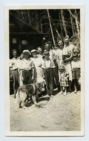
L to R: Art Hayes, Nerine Hayes, Frank Hayes, Florence McKay, Gwen Campbell, Fraser Campbell.
Front: Bobby Hayes, Irene Hayes, Clarence Byers and Queenie the dog.
L to R: Art Hayes, Nerine Hayes, Frank Hayes, Florence McKay, Gwen Campbell, Fraser Campbell.
Front: Bobby Hayes, Irene Hayes, Clarence Byers and Queenie the dog.
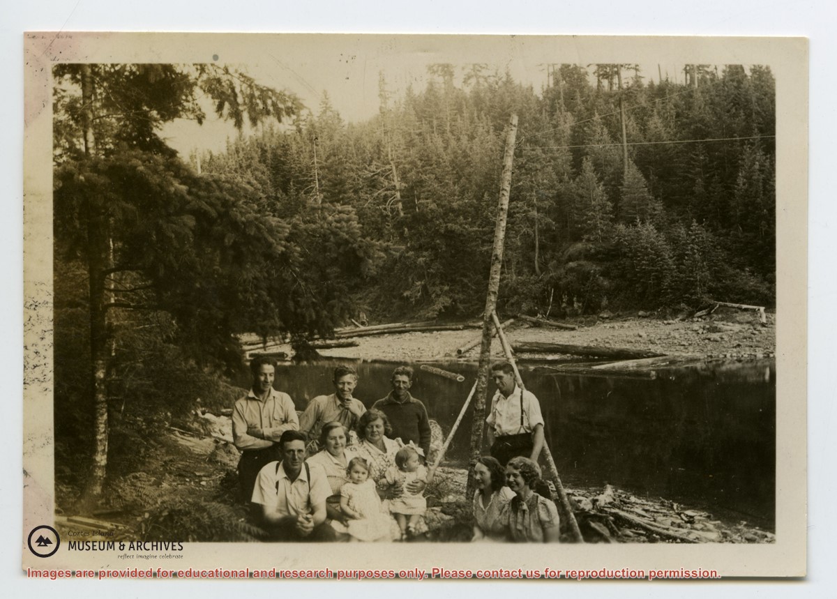
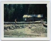
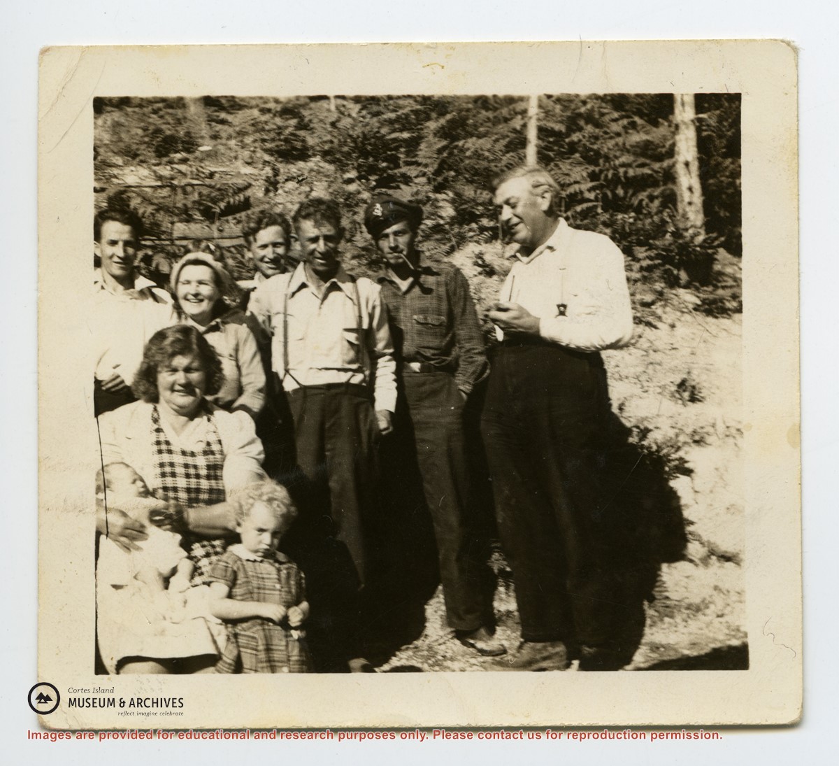
Photo depicts a group of people who lived at the Von Donop creek logging camp (buildings not shown).
Back: Scotty McKenzie, Clarence Byers, Henry Byers, Ken Hansen
Seated: Ervin McKay, Florence McKay, Ruth Byers
End at right: Hazel Hansen, Amy McKenzie
Babies: Irene and Lorraine Byers
Photo depicts a group of people who lived at the Von Donop creek logging camp (buildings not shown).
Back: Scotty McKenzie, Clarence Byers, Henry Byers, Ken Hansen
Seated: Ervin McKay, Florence McKay, Ruth Byers
End at right: Hazel Hansen, Amy McKenzie
Babies: Irene and Lorraine Byers
Series consists of a hand drawn map of Cortes Island showing places of interest to visitors, maps showing the location of hydro distribution lines on Cortes Island, maps related to zoning and rezoning on Cortes Island, the Official Settlement Plan, and a drawing showing an engineering plan for the Whaletown ferry terminal.
Series consists of a hand drawn map of Cortes Island showing places of interest to visitors, maps showing the location of hydro distribution lines on Cortes Island, maps related to zoning and rezoning on Cortes Island, the Official Settlement Plan, and a drawing showing an engineering plan for the Whaletown ferry terminal.
File contains hand-drawn maps from the early 1900s. There are two copies of the plan of part of SW 1/4 of Section 34; a plan of Gorge Harbour with names of owners written in; and a plan showing part of Read Island.
File contains hand-drawn maps from the early 1900s. There are two copies of the plan of part of SW 1/4 of Section 34; a plan of Gorge Harbour with names of owners written in; and a plan showing part of Read Island.

.jpg?width=1200&404=no-img.jpg&watermark=wmk)
.jpg?width=1200&404=no-img.jpg&watermark=wmk)
.jpg?width=180&404=no-img.jpg)