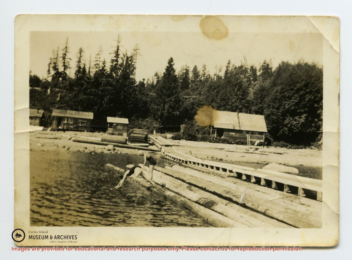
Photo depicts a line of buildings on the shore at Seaford, with a long wharf going into the water. Hazel McKay and Audrey Denny are diving into the water from logs beside the wharf. Photograph is stained and creased.
Photo depicts a line of buildings on the shore at Seaford, with a long wharf going into the water. Hazel McKay and Audrey Denny are diving into the water from logs beside the wharf. Photograph is stained and creased.
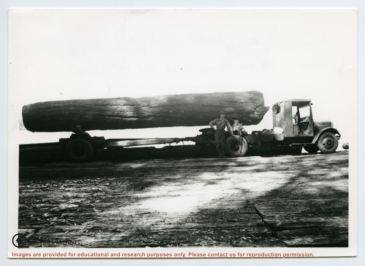
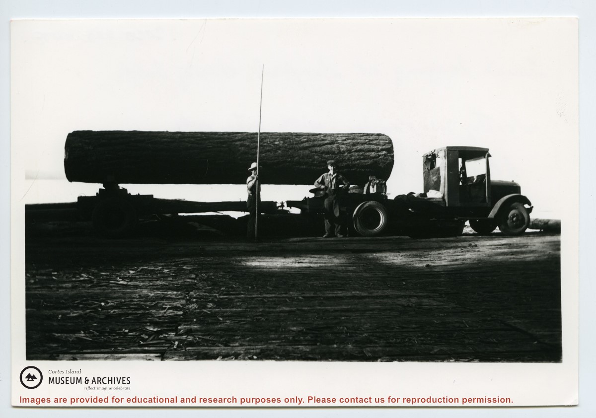
Verso: "Truck logging at Seaford, Cortez Isld. Scotty McKenzie with pike pole. Clarence Byers truck driver. Hayes Anderson truck.
Moved to Von Donop Oct 1st, 1939.
Five families:
1. Henry and Ruth Byers
2. Ervin and Florence McKay
3. Clarence and Etta Byers
4. Scotty and Amy McKenzie
5. Ken and Hazel Hansen
Ervin and Florence were parents of Etta and Hazel.
Henry and Ruth were parents of Amy and Clarence.
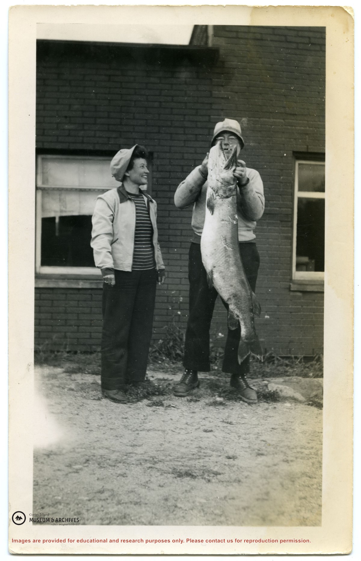
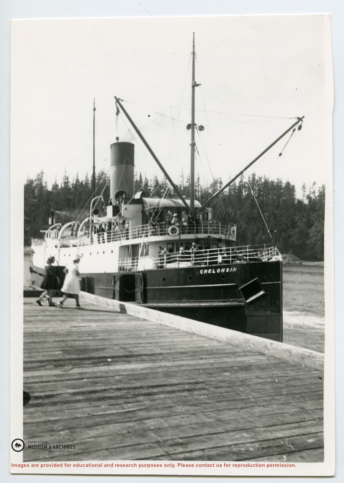
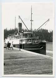
Fonds consists of ten photographs (nine black and white; 1 coloured) depicting members of the extended Byers/ Manson families, logging at Seaford and Von Donop Inlet, and the Union Steamship Chelohsin.
Henry and Ruth Byers, Ervin and Florence (Manson) McKay, Clarence and Etta (McKay) Byers, Ken and Hazel (McKay) Hansen, Scotty and Amy (Byers) McKenzie moved to Von Donop Inlet in 1939, where they ran a logging operation.
Custodial History
Found in Information Files folder (Byers family), August 1, 2020 and transferred to Archives.
Scope and Content
Fonds consists of ten photographs (nine black and white; 1 coloured) depicting members of the extended Byers/ Manson families, logging at Seaford and Von Donop Inlet, and the Union Steamship Chelohsin.
File contains a photocopy image of the Peter Police homestead at Carrington Lagoon, handwritten stories by Bud Dewar, an article about Ned Breeze, a photocopy of Gary and Velma Bergman at the Whaletown store, and a list of Seaford School.
File contains a photocopy image of the Peter Police homestead at Carrington Lagoon, handwritten stories by Bud Dewar, an article about Ned Breeze, a photocopy of Gary and Velma Bergman at the Whaletown store, and a list of Seaford School.
File contains newspaper clippings about a visit of the Whaletown School class to Vancouver; a "Whaletown Round-Up" column written by Gilean Douglas, 1956; a photocopy of an article about the purchase of Smelt Bay Park, 1973; and a craft store in Whaletown, 1975.
File contains newspaper clippings about a visit of the Whaletown School class to Vancouver; a "Whaletown Round-Up" column written by Gilean Douglas, 1956; a photocopy of an article about the purchase of Smelt Bay Park, 1973; and a craft store in Whaletown, 1975.
File contains title information and photocopies of land grants and subsequent conveyances for the following:
John Williams: 1914, Crown Grant for the fractional SW 1/4 of Sec 22 and fractional NW 1/4 of Sec 22 (east of Gorge Harbour entrance)
John Williams: 1914, Crown Grant for the fractional SW 1/4 of Sec 22 and frac. NW 1/4 of Sec 18 (west of the Gorge Harbour entrance)
File contains three oversize maps which are stored in the map cabinet: Map of Section 22, Plan VIP52378, Lots A,B,C (blueprint map; 85 cm x 54 cm, 1985); map of Plan 27966 (blueprint map; 55 cm x 43 cm, 1974); photocopy of map of fractional NW 1/4 Sec 17 (55 cm x 43 cm, 1973)
(Files 3 through 7 are from the same envelope.)
File contains a photocopy of Crown Grant and documentation of subsequent changes in title for:
William Barrett Lennard: 1928, Crown Grant for the SE and SW 1/4s of Section 23 (on the SE shore of Gorge Harbour)
(Files 3 through 7 are from the same envelope.)
File contains a photocopy of Crown Grant and documentation of subsequent changes in title for:
William Barrett Lennard: 1928, Crown Grant for the SE and SW 1/4s of Section 23 (on the SE shore of Gorge Harbour)
(Files 3 through 7 are from the same envelope.)
File contains a photocopy of Crown Grant and documentation of subsequent changes in title for:
Eliza Breeze: 1920, Crown Grant for Fractional NW 1/4 of Section 18 (east of the entrance to Gorge Harbour)
(Files 3 through 7 are from the same envelope.)
File contains a photocopy of Crown Grant and documentation of subsequent changes in title for:
Eliza Breeze: 1920, Crown Grant for Fractional NW 1/4 of Section 18 (east of the entrance to Gorge Harbour)
(Files 3 through 7 are from the same envelope.)
File contains a section map showing properties southeast of Gorge Harbour and title information on the property, later owned by Gilean Douglas, and known as Channel Rock.
To John Pool: 1930, Crown Grant of the W 1/2 of the SE 1/4 of Sec. 21 and fractional SW 1/4 of Sec. 21 and Crown Grant fo the fractional E 1/2 of fractional SE 1/4 of Sec. 21
File contains a photocopied section map of the northern part of Cortes Island (from just south of Gorge Harbour), coloured to indicate areas for which a Crown Grant was located and areas of ungranted Crown land which still appear to be owned by the government. Scale is 1 mile to 1 inch.
File contains a photocopied section map of the northern part of Cortes Island (from just south of Gorge Harbour), coloured to indicate areas for which a Crown Grant was located and areas of ungranted Crown land which still appear to be owned by the government. Scale is 1 mile to 1 inch.
File contains a coloured map with researched properties coloured in, and title information and photocopies of land grants and subsequent conveyances for the following:
Edward James Breeze: 1931, Crown Grant for District Lot 1373 (parts of Section 23 and Section 17, at the southeast end of Gorge Harbour by Anvil Lake)
Frank Harper: 1913, Crown Grant for the NE 96 acres of Section 23 (at the northeast end of Gorge Harbour)
(Files 3 through 7 are from the same envelope.)