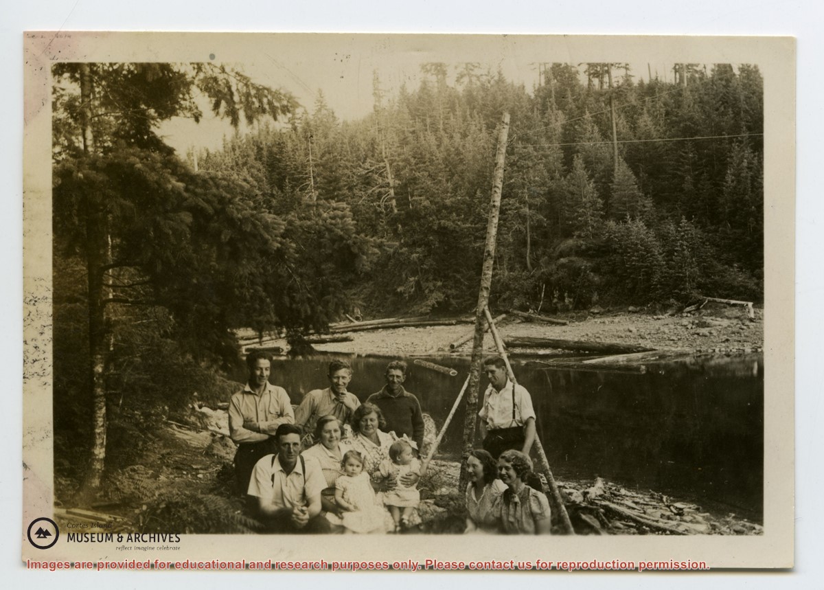
Photo depicts a group of people who lived at the Von Donop creek logging camp (buildings not shown).
Back: Scotty McKenzie, Clarence Byers, Henry Byers, Ken Hansen
Seated: Ervin McKay, Florence McKay, Ruth Byers
End at right: Hazel Hansen, Amy McKenzie
Babies: Irene and Lorraine Byers
Photo depicts a group of people who lived at the Von Donop creek logging camp (buildings not shown).
Back: Scotty McKenzie, Clarence Byers, Henry Byers, Ken Hansen
Seated: Ervin McKay, Florence McKay, Ruth Byers
End at right: Hazel Hansen, Amy McKenzie
Babies: Irene and Lorraine Byers
File contains notes, photocopies of Crown Grants and subsequent title changes for:
William John Sheepwash: 1916, Crown Grant for fractional NE 1/4 of Sec. 45; 153 acres for $153
For Block A of District Lot 744:
-to Gwynn Henry Meredith: 1918, Crown Grant for 59 acres for $1
-to Alfred Edward Layton: 1970, Crown Grant for 59 acres for $460
William Carr Smith: 19??, Crown Grant for District Lot 1170 at Von Donop Creek Lagoon; 155 acres for $1.00
Royal Wells Borden: 1937, Crown Grant for NW 1/4 of Sec 38
(Files 12 through 16 are from the same envelope.)
File contains information for Crown Grants and subsequent title changes for:
William John Sheepwash: 1916, Certificate of Title for District Lot 905 (on Von Donop Creek), 9.6 acres
William Black, Walter Black, William Reid Black and Marjory Black: 1930, Crown Grant for District Lot 1168, ca. 68 acres
William John Sheepwash: 1916, Crown Grant for fractional NE 1/4 of Sec. 45; 153 acres for $153.00
John Bruce Manson: 1942, Crown Grant for District Lot 903; 126 acres for $315.00
File also contains a photocopied map of Lot 903 and the NE 1/4 of Sec. 45, and a Subdivision Plan of Lot 1168 and part of blocks A & B, Lot 747 (1982; in the Map folder).
(Files 12 through 16 are from the same envelope.)
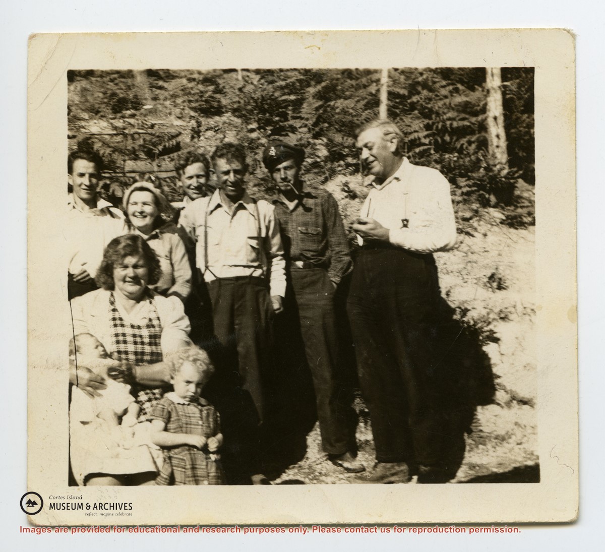
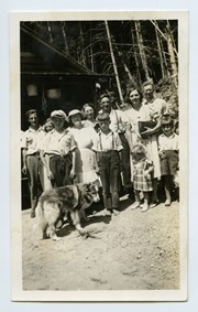
L to R: Art Hayes, Nerine Hayes, Frank Hayes, Florence McKay, Gwen Campbell, Fraser Campbell.
Front: Bobby Hayes, Irene Hayes, Clarence Byers and Queenie the dog.
L to R: Art Hayes, Nerine Hayes, Frank Hayes, Florence McKay, Gwen Campbell, Fraser Campbell.
Front: Bobby Hayes, Irene Hayes, Clarence Byers and Queenie the dog.
Series consists of photographs of Cortes Island people and places which were collected from various sources by Doreen Thompson during her work on Museum exhibits.
Series consists of photographs of Cortes Island people and places which were collected from various sources by Doreen Thompson during her work on Museum exhibits.
Fonds consists of ten photographs (nine black and white; 1 coloured) depicting members of the extended Byers/ Manson families, logging at Seaford and Von Donop Inlet, and the Union Steamship Chelohsin.
Henry and Ruth Byers, Ervin and Florence (Manson) McKay, Clarence and Etta (McKay) Byers, Ken and Hazel (McKay) Hansen, Scotty and Amy (Byers) McKenzie moved to Von Donop Inlet in 1939, where they ran a logging operation.
Custodial History
Found in Information Files folder (Byers family), August 1, 2020 and transferred to Archives.
Scope and Content
Fonds consists of ten photographs (nine black and white; 1 coloured) depicting members of the extended Byers/ Manson families, logging at Seaford and Von Donop Inlet, and the Union Steamship Chelohsin.
File contains genealogical information, photocopies of pictures, notes, and a CD labelled "Logan Family Photos" (2006.001.040 - stored in CD/DVD Album). Includes a photocopy of a World War I Diary of Dennis Walker.
File contains genealogical information, photocopies of pictures, notes, and a CD labelled "Logan Family Photos" (2006.001.040 - stored in CD/DVD Album). Includes a photocopy of a World War I Diary of Dennis Walker.
File contains information on subdivision and title changes, and a photocopy of the original Crown grant, in the Whaletown Lagoon area, to:
Samuel Thompson: 1894, Crown Grant for SW 1/4 of Section 35 and NW 1/4 of Section 34, 160 acres
File also contains four maps (stored in the Map Cabinet):
1) Subdivision map of part of NE 1/4 of Sec. 34 and part of NE 1/4 of Sec. 34, 1995
2) Subdivision Plan of NW 1/4 of Sec. 34 and NE 1/4 of Sec. 34 and part of E 1/2 of SE 1/2 of Sec. 34, 1995
3) Subdivision Plan of Lot A, NW 1/4 of Sec. 34, 1976
4) Subdivision Plan of part of NW 1/4 of Section 34, 1994
(Files 9 and 10 are from the same envelope.)
File contains title information to 1991 and a photocopy of the original Crown Grant to:
Nicholas Thompson: 1920, Crown Grant of Fractional SW 1/4 of Section 35; 54 acres on the southwest of Whaletown Bay
File contains a small explanatory map if a 5.5 acre portion of fractional SW 1/4 of Sec. 35, 1949, and a Subdivision Plan map of part of fractional SW 1/4 of Sec. 35, 1957 (stored in the Map Cabinet).
(Files 9 and 10 are from the same envelope.)
File contains photocopies of the original Crown Grants and subsequent title changes with plan maps.
To Moses Ireland: 1893, Crown Grant for the W 1/2 of the SW 1/4 of Section 35 and the fractional SE 1/4 of Section 35 (161 acres around Whaletown Bay
To George Alderson: 1961, Crown Grant for Lot 3 of Section 34
File contains a photocopied part of a map showing the locations of researched property in the Whaletown Lagoon and Whaletown Harbour area. The map is glued to an envelope which has a list of Crown grants and other conveyances on the back.
It contains photocopies of original land grants and other conveyances for the following:
Moses Ireland: 1893, Crown Grant for the W 1/2 of SW 1/4 of Sec 35 and W 1/2 of the SW 1/4 of Section 34
Joseph Youart: 1900, Crown Grant for Fractional NE 1/4 of Sec 35 (sold to Alice Robertson in 1908; "Burnside" is still in the Robertson family).
Nicholas Thompson: 1920, Crown Grant for the Fractional SW 1/4 of Sec 35
Charles Strange: 1914, Crown Grant for the NW 1/4 of Sec 35