"To Doris,Love from M. Freeman, Easter 1955" written on verso.
Back, L to R: Charlie Jeffery behind Ted Hansen, Linda Rexford, Doreen Guthrie, Lesley Forrest, MaryAnn Parry
Middle: Bert Summers, Barbie Pyner, Jenny Armstrong, Wayne Becque
Front: Keith Hawkins, Doris Hartman, Wendy Hansen, Nancy Layton (?), Johnny Hansen
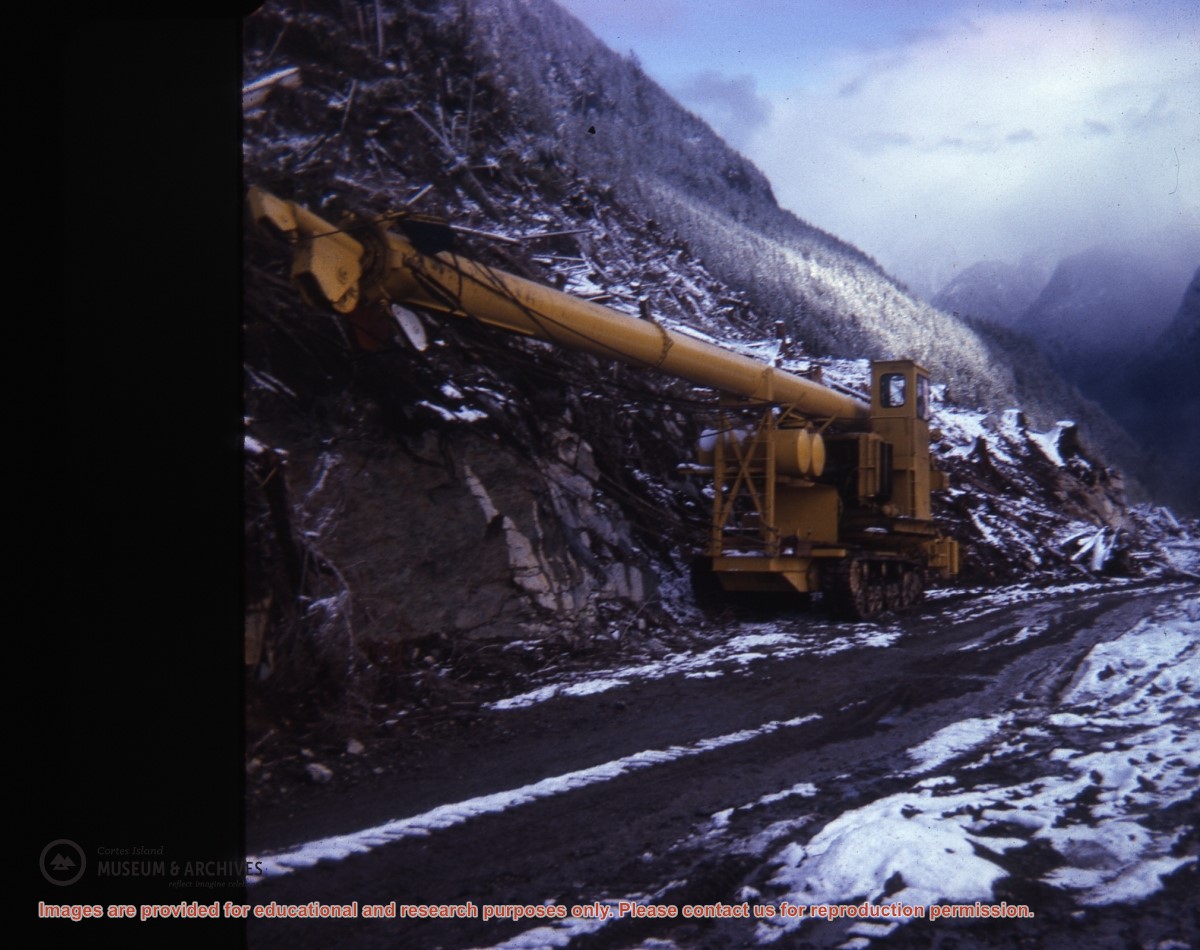
Part of a series of photographs taken by Don Maclean at a logging camp at the Quatam River in Ramsey Arm, BC. The camp was likely one of the stops on his patrol for the Columbia Coast Mission.
Slides were taken by Don Maclean and donated by Janice Kerr Maclean, Sept. 9, 2021.
Scope and Content
Part of a series of photographs taken by Don Maclean at a logging camp at the Quatam River in Ramsey Arm, BC. The camp was likely one of the stops on his patrol for the Columbia Coast Mission.
The base map is a zoning map produced by the Regional District of Comox-
Strathcona for the Cortes Island Land Use Project (Aug 1969). Edwards used
coloured pencil to show land and foreshore zones, and transferred information
about early preemptions and old roads and trails from an earlier map (see
Donald Palmer fonds, 2020.002.011, map of Cortes Island, Sayward District, ca.
1915).
Photograph of Mary Weiler walking onto the ferry after a surprise farewell party on the day she moved away from the island. Mary Weiler is facing the camera; John Ashby is center, with pipe; Brigid Weiler in the long skirt.
Photograph of Mary Weiler walking onto the ferry after a surprise farewell party on the day she moved away from the island. Mary Weiler is facing the camera; John Ashby is center, with pipe; Brigid Weiler in the long skirt.
File contains zoning maps for Bylaw 41, Electoral Area I, Schedules A1-A7 with revisions to 1999. There is a map of the whole island and larger scale maps of island areas.
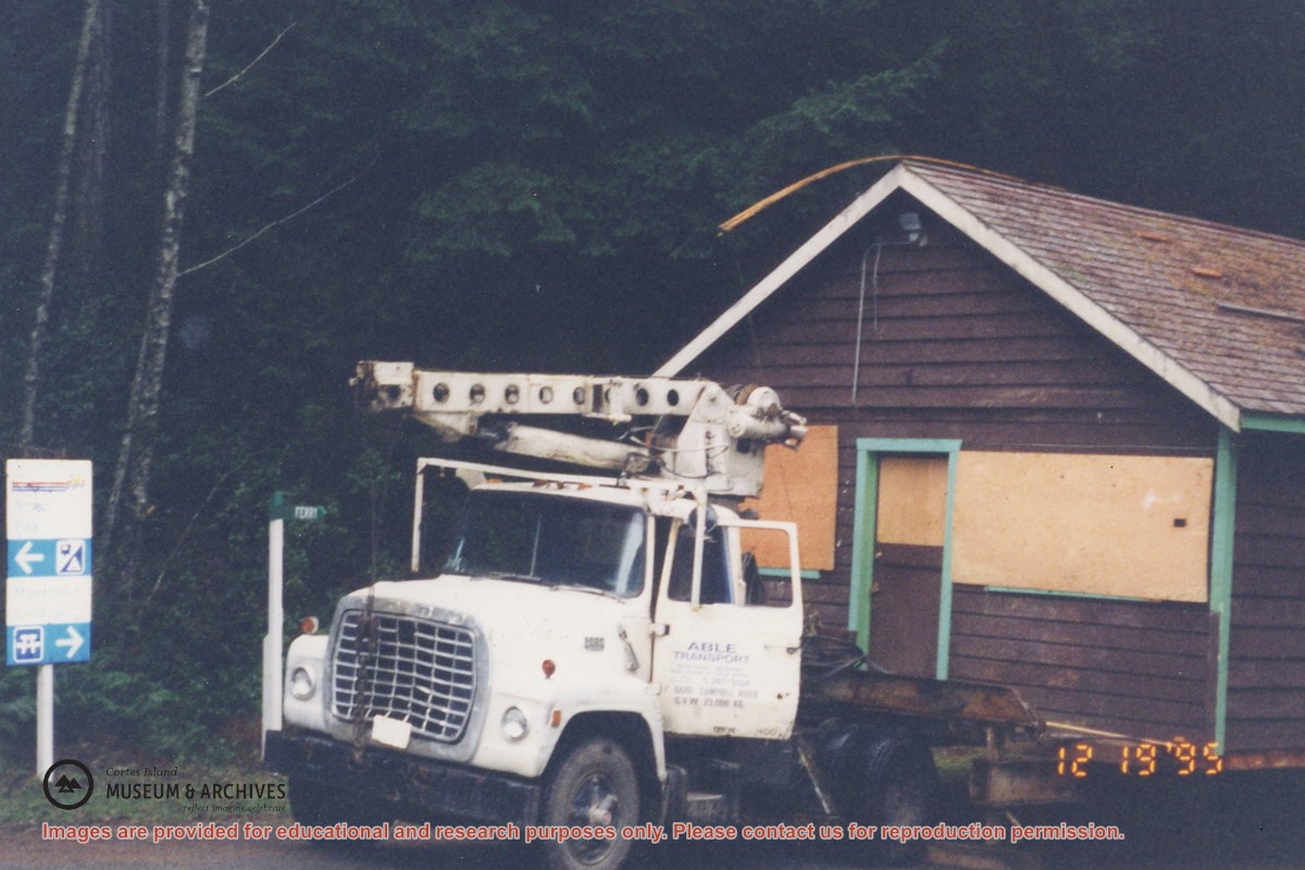
One of a series of 20 photographs documenting the move of the old Manson's Landing store from its position by the wharf in Mansons Landing Provincial Park to the present Museum site on Beasley Rd. The photographs are from an envelope labelled "Moving Museum, Dec. 1995. Moved by Able Transport. Paid for by Elmer and May Ellingsen."
Found in Information Files folder (Cortes Island Museum & Archives info"), Jan. 2021
Scope and Content
One of a series of 20 photographs documenting the move of the old Manson's Landing store from its position by the wharf in Mansons Landing Provincial Park to the present Museum site on Beasley Rd. The photographs are from an envelope labelled "Moving Museum, Dec. 1995. Moved by Able Transport. Paid for by Elmer and May Ellingsen."
One of a series of 20 photographs documenting the move of the old Manson's Landing store from its position by the wharf in Mansons Landing Provincial Park to the present Museum site on Beasley Rd. The photographs are from an envelope labelled "Moving Museum, Dec. 1995. Moved by Able Transport. Paid for by Elmer and May Ellingsen."
Found in Information Files folder (Cortes Island Museum & Archives info"), Jan. 2021
Scope and Content
One of a series of 20 photographs documenting the move of the old Manson's Landing store from its position by the wharf in Mansons Landing Provincial Park to the present Museum site on Beasley Rd. The photographs are from an envelope labelled "Moving Museum, Dec. 1995. Moved by Able Transport. Paid for by Elmer and May Ellingsen."
File contains Plan Map Schedule A-1, Development Proposal Referral forms about changing the zoning bylaw designations to reflect the Official Community Plan of 1995, the agenda for an APC meeting and photocopies of FOCI/CIFC maps of Cortes Island land tenure.
File contains Plan Map Schedule A-1, Development Proposal Referral forms about changing the zoning bylaw designations to reflect the Official Community Plan of 1995, the agenda for an APC meeting and photocopies of FOCI/CIFC maps of Cortes Island land tenure.
File contains a photocopied section map of the northern part of Cortes Island (from just south of Gorge Harbour), coloured to indicate areas for which a Crown Grant was located and areas of ungranted Crown land which still appear to be owned by the government. Scale is 1 mile to 1 inch.
File contains a photocopied section map of the northern part of Cortes Island (from just south of Gorge Harbour), coloured to indicate areas for which a Crown Grant was located and areas of ungranted Crown land which still appear to be owned by the government. Scale is 1 mile to 1 inch.
File contains a photocopied part of a map showing the locations of researched property in the Whaletown Lagoon and Whaletown Harbour area. The map is glued to an envelope which has a list of Crown grants and other conveyances on the back.
It contains photocopies of original land grants and other conveyances for the following:
Moses Ireland: 1893, Crown Grant for the W 1/2 of SW 1/4 of Sec 35 and W 1/2 of the SW 1/4 of Section 34
Joseph Youart: 1900, Crown Grant for Fractional NE 1/4 of Sec 35 (sold to Alice Robertson in 1908; "Burnside" is still in the Robertson family).
Nicholas Thompson: 1920, Crown Grant for the Fractional SW 1/4 of Sec 35
Charles Strange: 1914, Crown Grant for the NW 1/4 of Sec 35
File contains a map key to the areas of Sections 17, 18, 19, 22 and 34 (south of Gorge Harbour) which were researched (Information in Files 3-7).
It contains photocopies of original land grants and subsequent conveyances for the following:
Reginald James Smith: 1946, Crown Grant 165414I for fractional SE 1/4 of Sec 23, 1946 (the Thunder Road subdivision at the eastern end of Gorge Harbour).
(Files 3 through 7 are from the same envelope.)
File contains title information and photocopies of land grants and subsequent conveyances for the following:
John Williams: 1914, Crown Grant for the fractional SW 1/4 of Sec 22 and fractional NW 1/4 of Sec 22 (east of Gorge Harbour entrance)
John Williams: 1914, Crown Grant for the fractional SW 1/4 of Sec 22 and frac. NW 1/4 of Sec 18 (west of the Gorge Harbour entrance)
File contains three oversize maps which are stored in the map cabinet: Map of Section 22, Plan VIP52378, Lots A,B,C (blueprint map; 85 cm x 54 cm, 1985); map of Plan 27966 (blueprint map; 55 cm x 43 cm, 1974); photocopy of map of fractional NW 1/4 Sec 17 (55 cm x 43 cm, 1973)
(Files 3 through 7 are from the same envelope.)
File contains a coloured map with researched properties coloured in, and title information and photocopies of land grants and subsequent conveyances for the following:
Edward James Breeze: 1931, Crown Grant for District Lot 1373 (parts of Section 23 and Section 17, at the southeast end of Gorge Harbour by Anvil Lake)
Frank Harper: 1913, Crown Grant for the NE 96 acres of Section 23 (at the northeast end of Gorge Harbour)
(Files 3 through 7 are from the same envelope.)