Various maps of Cortes Island and surrounding areas with tourist info, trails, provincial parks, local businesses, sites, property lines, topography, charts, etc, 1916-present. Info on Hiking and Orienteering Map of Cortes Island, 2003, and Cortes Island Community Mapping Project, 2011. Info on Discovery Islands Ecosystem Mapping (DIEM), 2012-2014.
Various maps of Cortes Island and surrounding areas with tourist info, trails, provincial parks, local businesses, sites, property lines, topography, charts, etc, 1916-present. Info on Hiking and Orienteering Map of Cortes Island, 2003, and Cortes Island Community Mapping Project, 2011. Info on Discovery Islands Ecosystem Mapping (DIEM), 2012-2014.
File contains maps of Bute Inlet (1970), Cortes Island/Read Island and surrounding area (ca. 1950), Powell River (1968) and Cortes Island zoning maps (Jan 1974).
File contains maps of Bute Inlet (1970), Cortes Island/Read Island and surrounding area (ca. 1950), Powell River (1968) and Cortes Island zoning maps (Jan 1974).
File contains hand-drawn maps from the early 1900s. There are two copies of the plan of part of SW 1/4 of Section 34; a plan of Gorge Harbour with names of owners written in; and a plan showing part of Read Island.
File contains hand-drawn maps from the early 1900s. There are two copies of the plan of part of SW 1/4 of Section 34; a plan of Gorge Harbour with names of owners written in; and a plan showing part of Read Island.
List of pre-emptions on Hernando from records in archives, Victoria, BC, 1888-1900, and maps showing preemtions. Excerpts from Goosegrass and Buttercups, D.C. Kirk, and Chalkdust and Outhouses: WC Schools 1893-1950, Barbara Ann Lambert. Emails with info on the island's history and related families, Manson, Conant, Baker, 2016-2017. Additional info on the island's history
List of pre-emptions on Hernando from records in archives, Victoria, BC, 1888-1900, and maps showing preemtions. Excerpts from Goosegrass and Buttercups, D.C. Kirk, and Chalkdust and Outhouses: WC Schools 1893-1950, Barbara Ann Lambert. Emails with info on the island's history and related families, Manson, Conant, Baker, 2016-2017. Additional info on the island's history
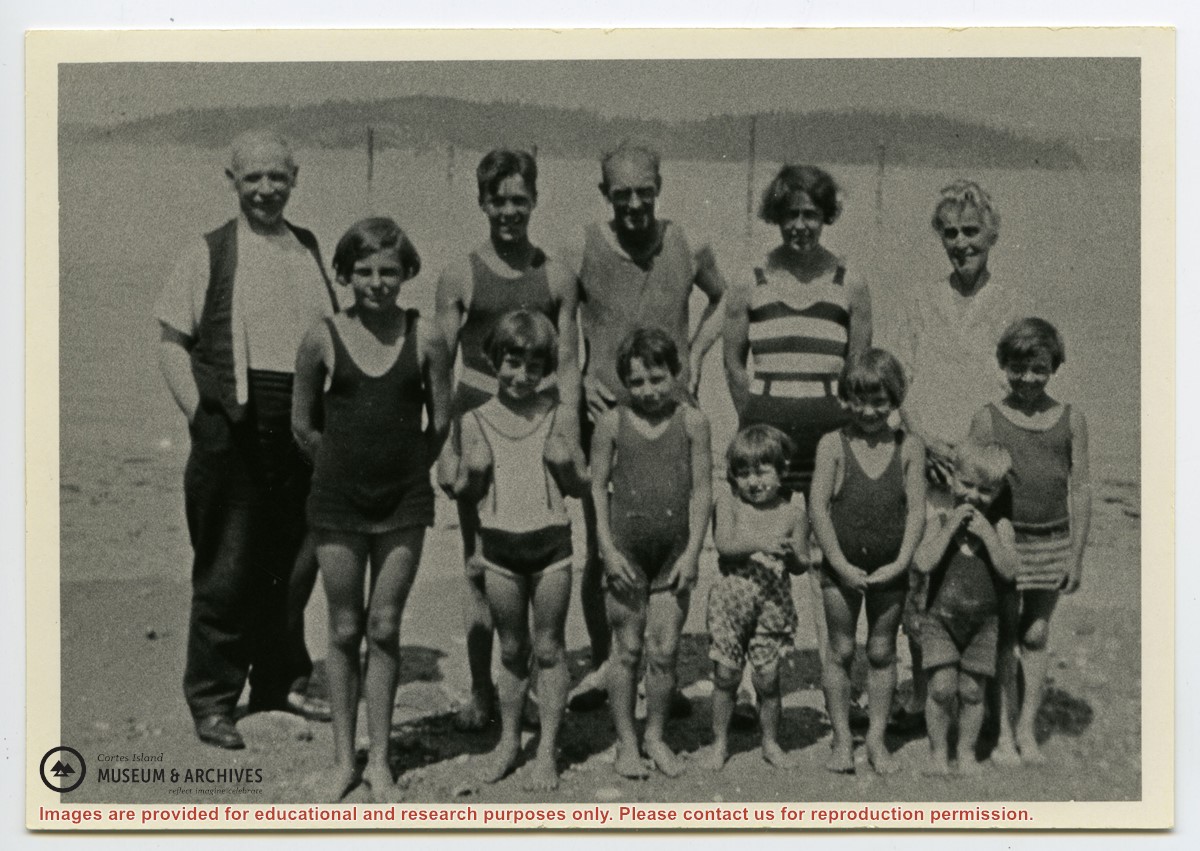
Photograph shows members of the Michael Manson extended family in bathing costumes. The are identified as Mr. Niven, Muriel Hurren, Jim Niven, Dick Parker, Thelma Campbell, Audrey Kenny, Jean Manson, Eileen Kenny, Minerva Campbell, Mrs. Niven, Dorothy Manson and Lorne Campbell.
Photograph shows members of the Michael Manson extended family in bathing costumes. The are identified as Mr. Niven, Muriel Hurren, Jim Niven, Dick Parker, Thelma Campbell, Audrey Kenny, Jean Manson, Eileen Kenny, Minerva Campbell, Mrs. Niven, Dorothy Manson and Lorne Campbell.
The base map is a zoning map produced by the Regional District of Comox-
Strathcona for the Cortes Island Land Use Project (Aug 1969). Edwards used
coloured pencil to show land and foreshore zones, and transferred information
about early preemptions and old roads and trails from an earlier map (see
Donald Palmer fonds, 2020.002.011, map of Cortes Island, Sayward District, ca.
1915).
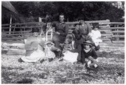
Photograph of Jane Manson, granddaughter Thelma Campbell, Fraser Campbell with Shep the dog, Gwen Campbell with baby Minerva, Ervin (Ervie) McKay with Hazel, and Etta McKay in front.
This is a reprint of an original photograph from the collection of Florence McKay. It is part of the Campbell River Museum collection (CR 13650) and is also reproduced in the May Ellingsen Historic Photograph Collection: Album Nine, page 28.
Found in CIMAS Information Files folder (Hernando Island), with May Ellingsen's handwriting on the verso. (January 2021)
Scope and Content
Photograph of Jane Manson, granddaughter Thelma Campbell, Fraser Campbell with Shep the dog, Gwen Campbell with baby Minerva, Ervin (Ervie) McKay with Hazel, and Etta McKay in front.
This is a reprint of an original photograph from the collection of Florence McKay. It is part of the Campbell River Museum collection (CR 13650) and is also reproduced in the May Ellingsen Historic Photograph Collection: Album Nine, page 28.